Just Me Travel

Just Me Travel

Solo Travel Blogger

Category: Photo Stories

The photos tell the story

15 PHOTOS TO INSPIRE YOU TO VISIT THE UNIQUE SASSI MATERA, ITALY (2024 Updated)

Sassi di Matera: The Stone City of Italy and a UNESCO World Heritage Site Steeped in History and Charm.   Welcome to the mesmerising world of Sassi di Matera, a…

Sassi di Matera: The Stone City of Italy and a UNESCO World Heritage Site Steeped in History and Charm.


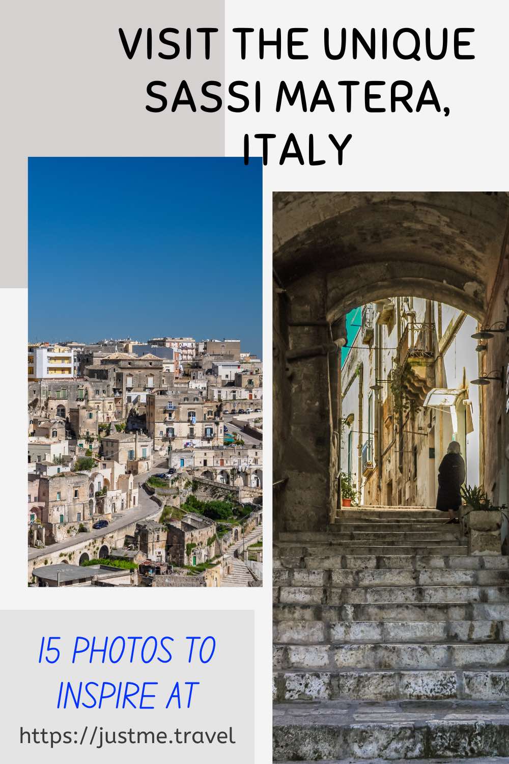
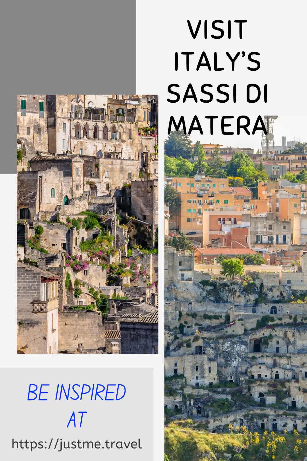
Welcome to the mesmerising world of Sassi di Matera, a unique and ancient destination. Matera, a city in Italy’s southern region of Basilicata, is renowned for its extraordinary cave dwellings and rock-cut architecture, collectively known as the Sassi. These ancient settlements, carved into limestone cliffs, have earned the Sassi di Matera a place on UNESCO’s World Heritage List and have captivated visitors with their rich history, unique charm, and breathtaking landscapes.

In this travel blog post, I’ll take you on a visual journey through 15 stunning photos that capture the essence and allure of the Sassi di Matera. Each image tells a story, inviting you into a world where cave dwellings, narrow winding streets and alleyways, and rock-cut architecture create an otherworldly landscape.

Whether you’re a history buff, a culture enthusiast, or simply seeking a destination off the beaten path, Sassi di Matera offers an unforgettable experience. Let these photos inspire you to pack your bags and immerse yourself in the wonders of this timeless Italian gem.


Situated in the “instep” of Italy’s “boot”, Sassi di Matera (literal translation from Italian, “Stones of Matera”) were declared a World Heritage Site by UNESCO in 1993, while Matera was awarded the 2019 European Capital of Culture. However, Matera, particularly the Sassi, did not always deserve these honours. Not so many decades ago, Matera’s Sassi was a place of national humiliation dubbed the “Shame of Italy”.

The Sassi di Matera has two districts – Sasso Caveoso and Sasso Barisano. They are ancient! – prehistoric troglodyte settlements where people have lived in cave dwellings since 7000 BC.

The Sassi have a colourful history that has seen them go from the earliest inhabited city in Italy to a place of national humiliation to Italy’s pride. This history, which is still visible today, makes Sassi di Matera a matchless tourist destination.


A brief history – from shame to honour

In his book Christ Stopped at Eboli (published in 1945), Carlo Levi put Sassi di Matera on the world map when he highlighted the poor living conditions. He painted a picture of abject poverty. Malaria, cholera and typhoid were rampant in the Sassi. Families and their animals were living together under the same roof in dwellings with no natural light or ventilation, no electricity, water or sewers, and there was a high rate of infant mortality.

The Sassi became an embarrassment to the Italian Government. So much so that in 1950, the Prime Minister declared a state of emergency and put plans in place to move the Sassi’s inhabitants out. By 1952, the Sassi were empty – abandoned through forced removal.

After sitting dormant for a few decades, the Sassi began to transform, starting in the 1970s with artists and hippies rediscovering Matera’s Sassi. This urban renewal and a younger generation expressing their desire to bring the caves back to life led the Italian Government to pass a law in 1986 to repopulate the Sassi, connecting water and electricity and subsidising restoration work to encourage the Sassi’s revival.

And the people did come – restoring caves as homes, hotels, restaurants and bars. But many are still uninhabitable.

Cave houses, many of which are abandoned, in a troglodyte settlement in Italy.

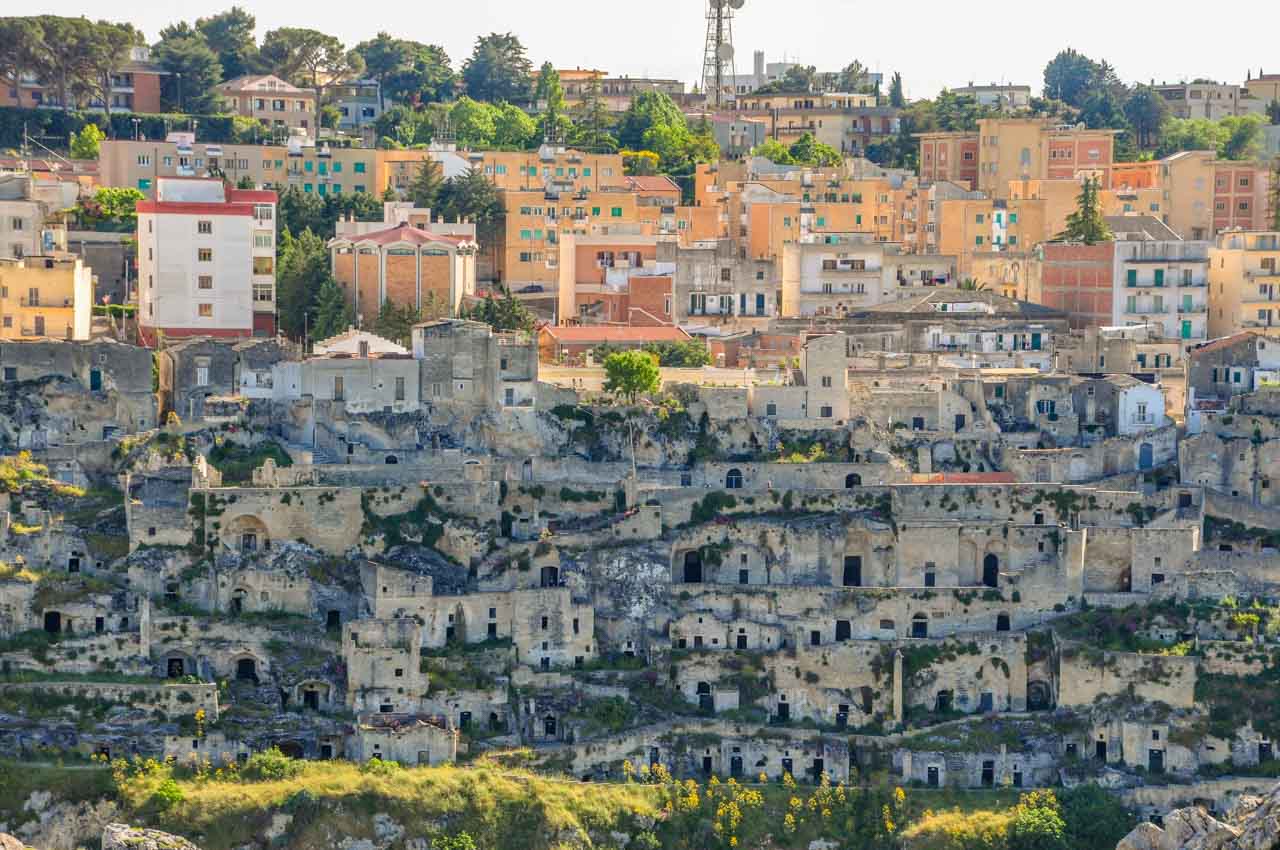
Abandoned cave dwellings in Matera’s Sassi.


Cave houses in a troglodyte settlement. Some are obviously uninhabited.

Not all the cave dwellings in the Sassi are inhabited.


Sassi di Matera’s revival was further cemented in 1993 when UNESCO listed it as a World Heritage Site for being “the most outstanding, intact example of a troglodyte settlement in the Mediterranean region” and being named 2019 European Capital of Culture.

Matera has reclaimed its dignity and credibility in the eyes of Italy and the world.


Discover Sassi di Matera

I travelled to Matera on a 17-day small group tour with Albatross Tours on their Italy, the Deep South & Sicily tour, staying two nights in the Sassi.

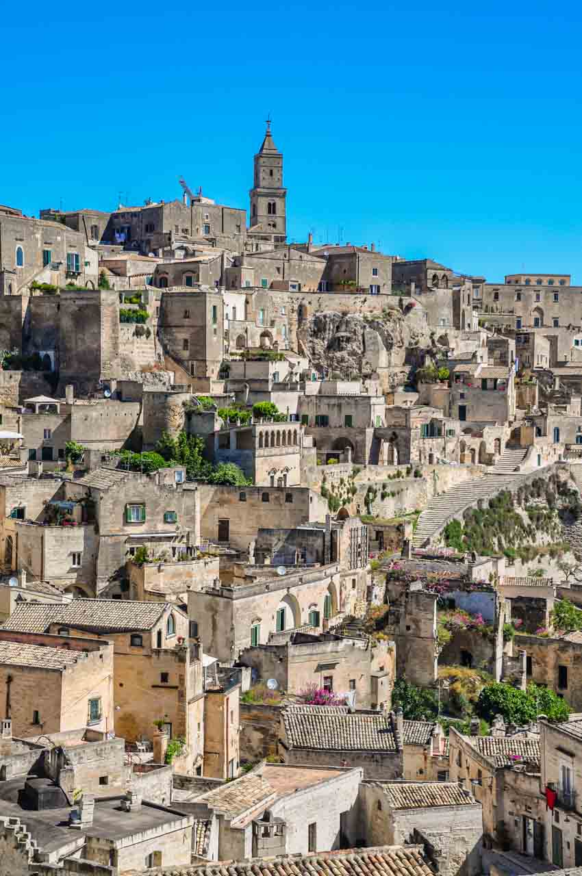
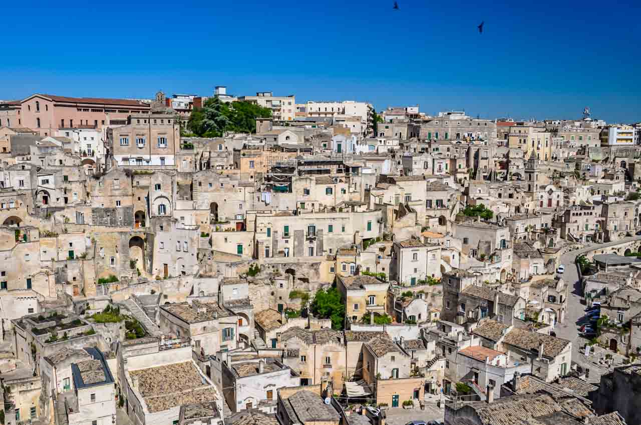
The Sassi are carved into the limestone cliffs of a deep ravine gouged out by the Gravina River. First viewed from across the ravine, the Sassi di Matera were like nothing I had seen before. I have visited Troglodyte caves in France and spent time in Cappadocia in Turkey. But the Sassi di Matera, with caves stacked on each other while clinging to the steep slope, was a stand-alone matchless sight. Then, creating a unique juxtaposition, the modern city of Matera overlooks the Sassi from its height at the top of the hill.

A mass of cave houses on a hill are viewed from across a ravine. There is a stone church bell tower on top of the hill.

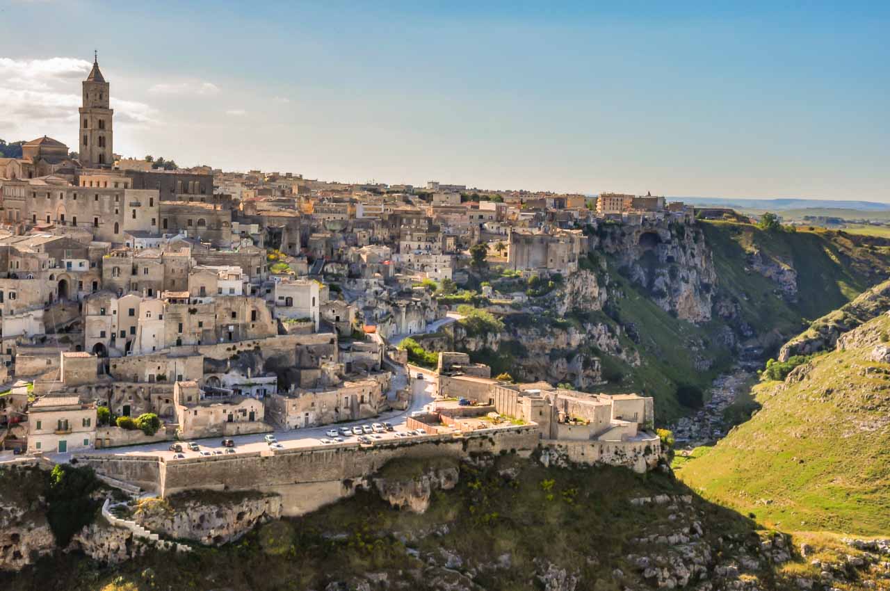
Sassi di Matera viewed from across the ravine.


An abandoned troglodyte settlement (cave dwellings) sits below a modern city on the side of a hill.

The modern city of Matera sits on top of the ancient Sassi.


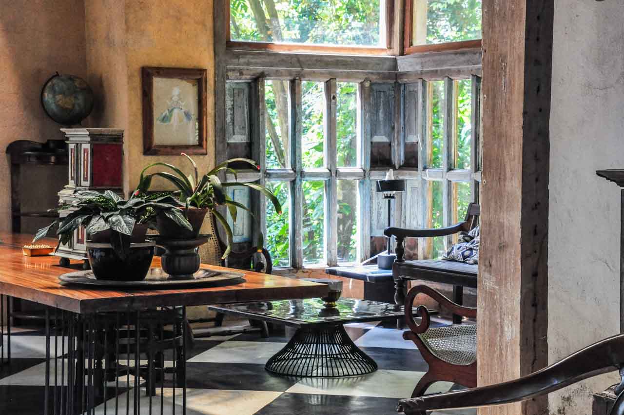
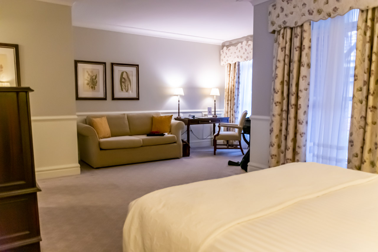
My first ‘taste’ of Sassi di Matera and what it must be like to live in the Sassi was my accommodation for two nights in the luxury Le Grotte della Civita – a cave hotel on the edge of the ravine in the most ancient Sassi area.

A hotel room in a cave, with a double bed, bath, and table and chairs. the cave room is lit by candles.

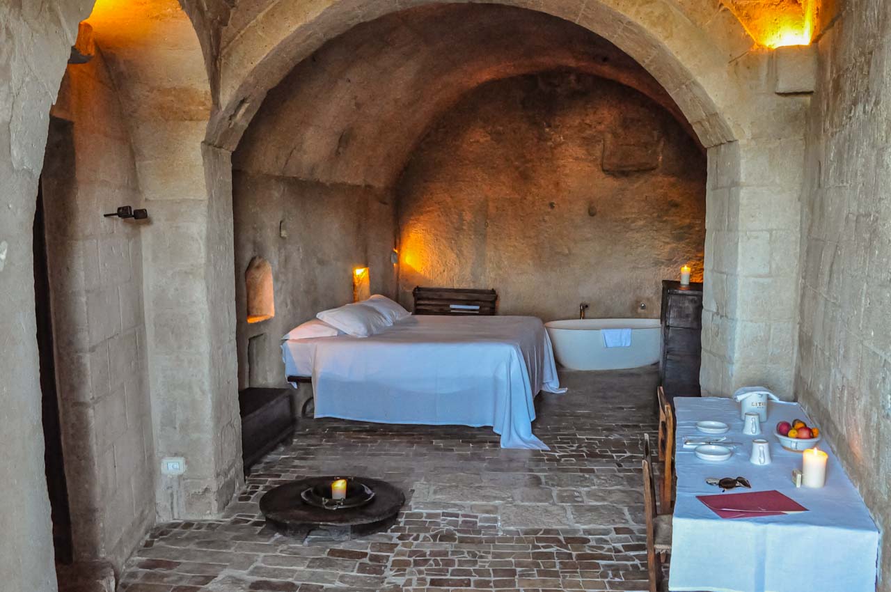
My hotel room – a restored cave in Le Grotte della Civita.


Le Grotte della Civita consists of 18 large ‘rooms’ with ensuites. All the rooms are individual caves that have been beautifully restored whilst retaining their original features. The furnishings were simple but tasteful, with much of the lighting provided by candles. The breakfast was served in a reclaimed cave that was once a church and was typical of southern Italy – consisting of various breads, cakes, pastries, meats, jams and cheeses. My stay at Le Grotte della Civita was truly memorable.

After a very comfortable night’s sleep and a delicious breakfast, I joined the walking tour in the morning with a local guide. Walking tours are a great way to get acquainted with a city and learn its history. The walking tour of Sassi di Matera was a fascinating history lesson while being introduced to significant sites. The tour included visiting a cave dwelling to see how families lived in their stone houses and viewing one of the ancient Rupestrian Churches with its biblical frescoes on the cave walls dating back to the Middle Ages.

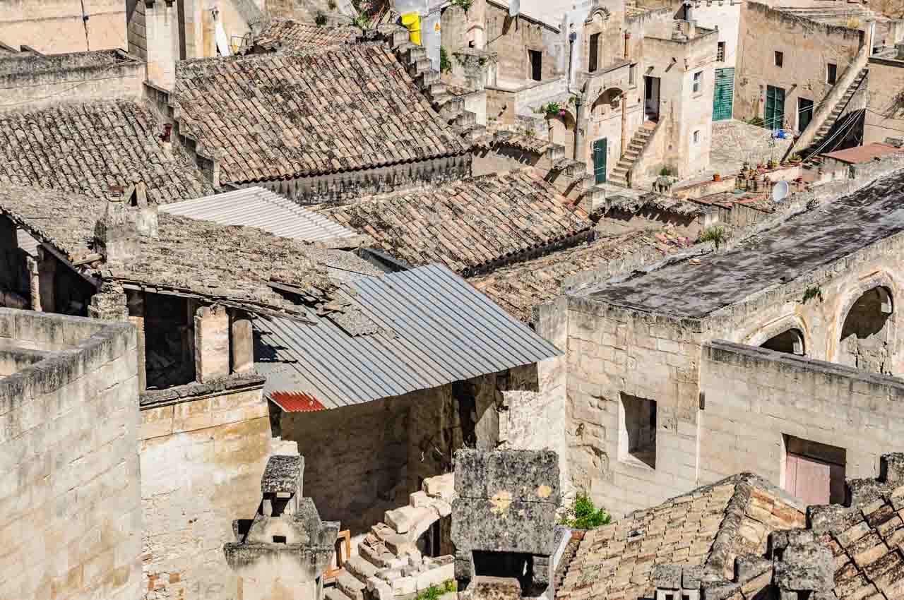
By the end of the tour, I felt prepared to spend the afternoon and evening on my own, exploring and discovering the labyrinth that is Sassi di Matera. I was in my element, walking around the narrow streets and alleyways, talking to the locals, checking out their cafes, and having all the time I wanted to take photos. A word of advice: you will need comfortable shoes to walk around the Sassi as there are many steep steps to negotiate, given the Sassi are built on the side of a ravine.

An elderly lady dressed in black walks up stone steps that are under a stone arch.

There are lots of steps in Sassi di Matera.


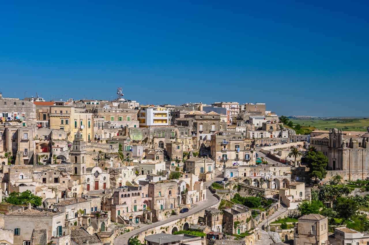
Matera has 180 churches, 40 of which are in the Sassi, including the Cathedral and the rock-cut Church of Santa Maria di Idris.

A rock-cut church on top of a green hill with cave dwellings below it.

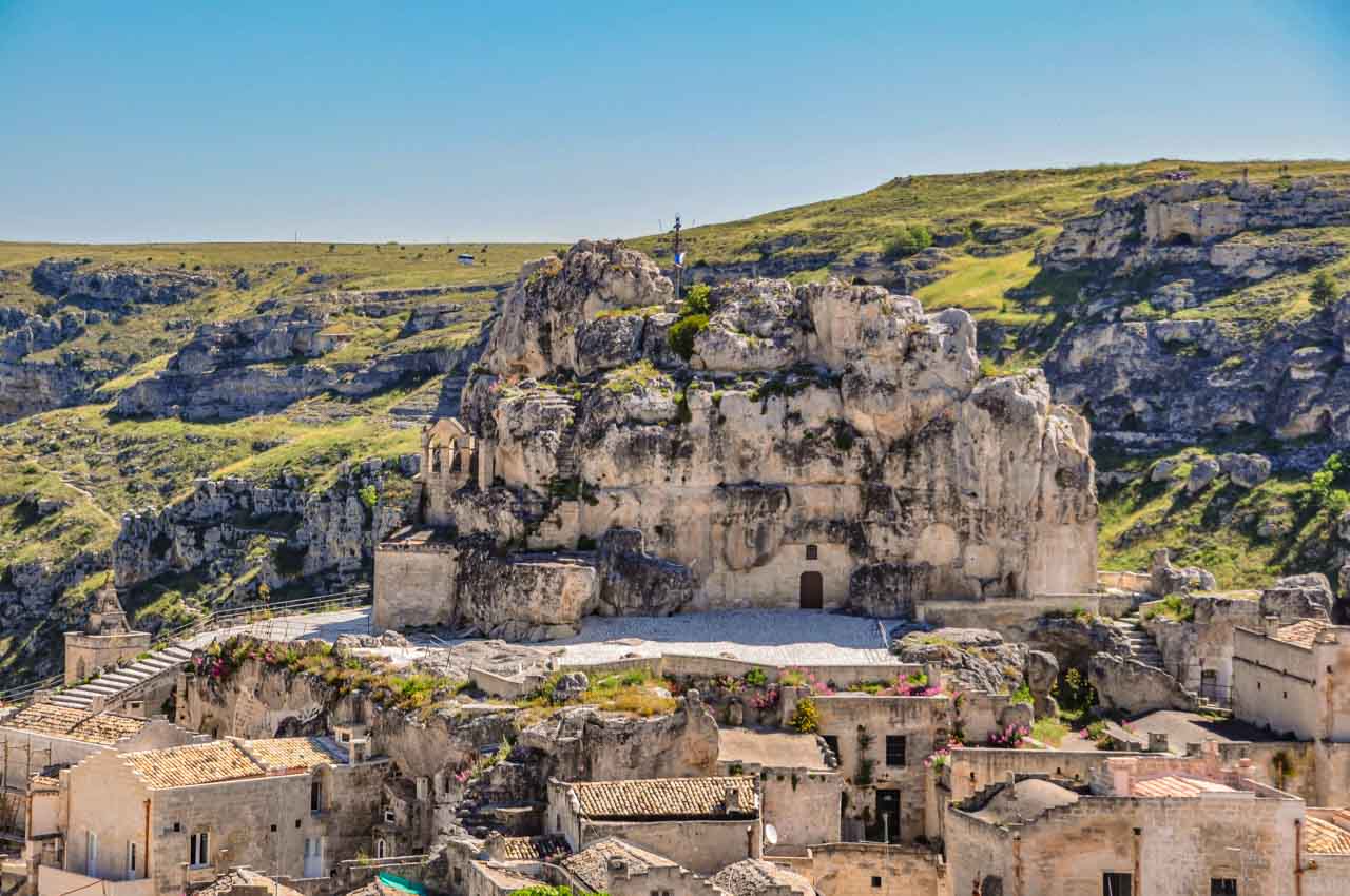
The Church of Santa di Idris.


My favourite church was the Church of Purgatory, constructed as a place for people to pray for the souls trapped in limbo between heaven and hell. Completed in 1747, its recurring and only theme is that of death. The baroque façade of the church and its doors are covered with carvings of skulls, skeletons, crossbones, and other death-related decor. While a church focusing on death might seem a bit Grim Reaper-ish, it was fashionable at the time of construction, as death was not seen as the end but as the beginning of a new life.

A skull and two skeletons carved into stone. One skeleton is holding an hourglass, and the other skeleton is holding a scythe.

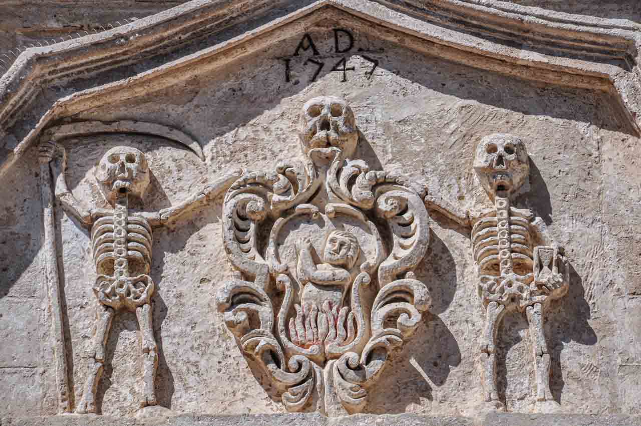
Skulls and skeletons on the facade of the Church of Purgatory.


A wooden door carved with square panels of skulls and cross bones.

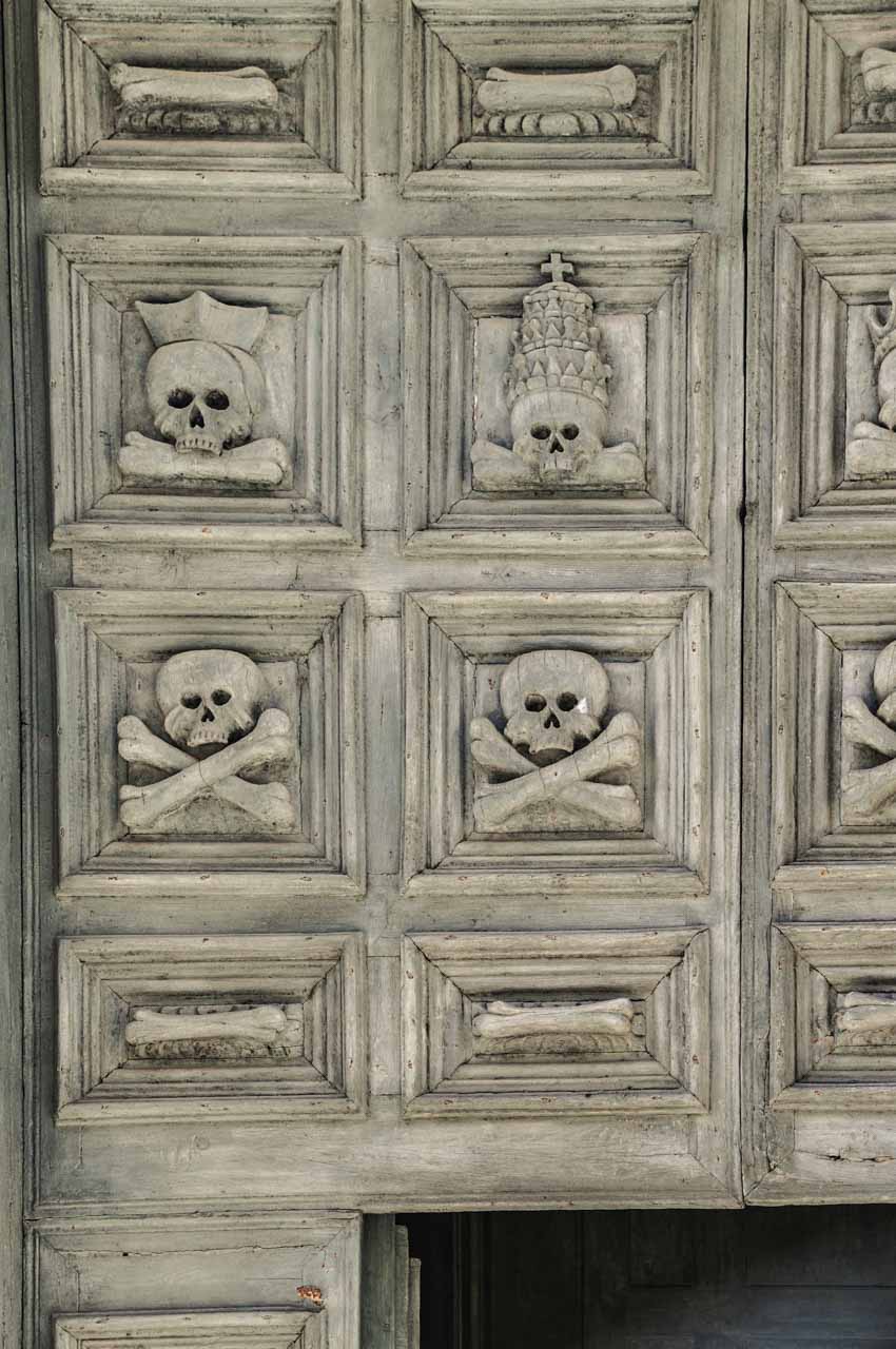
The Church go Purgatory’s carved wooden door.


Exploring the Sassi di Matera

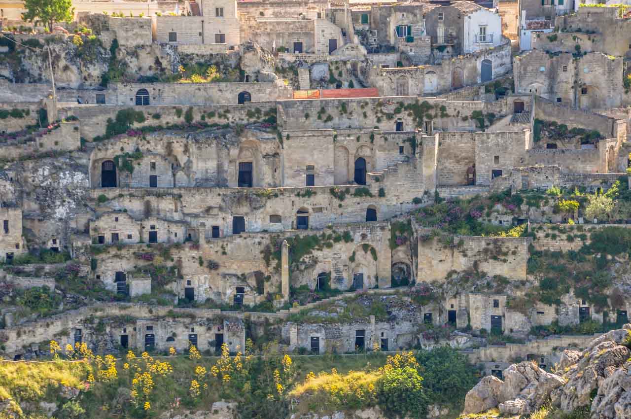
While the Sassi may look like masses of houses, the house-like facades are only that, as the ‘houses’ are dug well into the rock, forming the cave dwellings Matera is famous for.

A photo of stone houses that are actually caves.

In the Sassi di Matera, caves look like houses.


A settlement of cave houses surrounded by purple flowers and green shrubs.

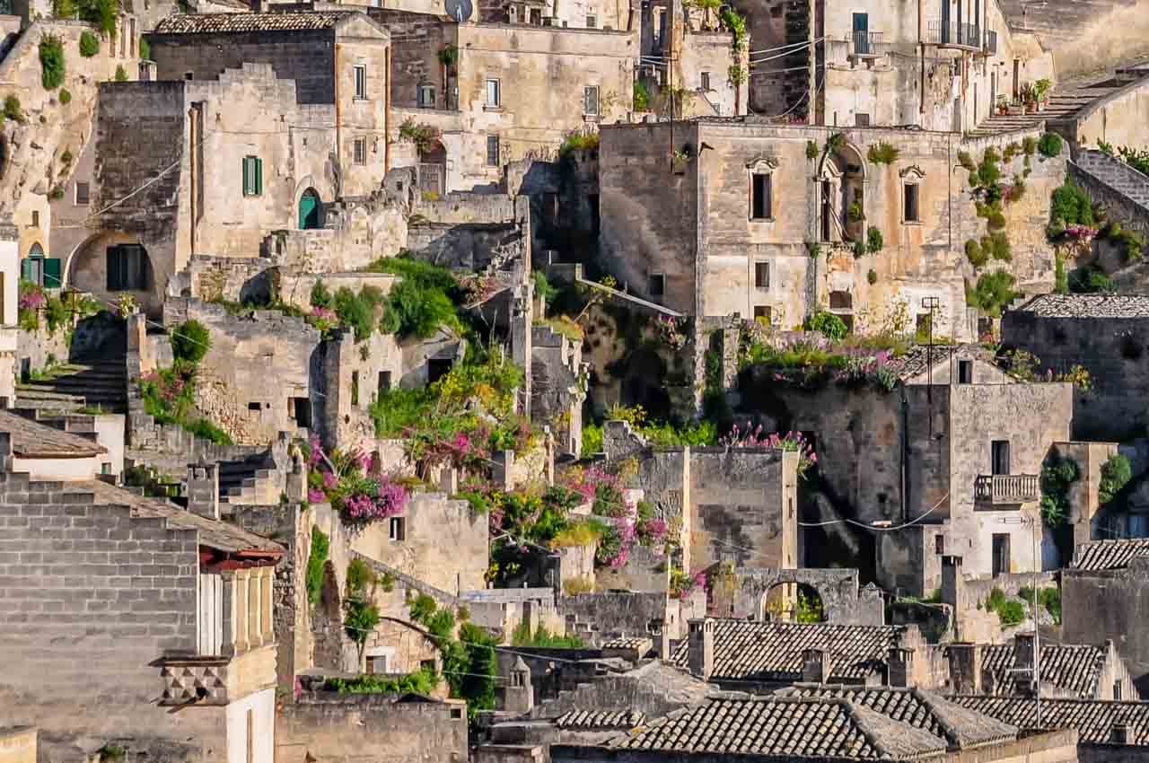
Sassi di Matera – a mass of cave dwellings that look like houses.


Houses in the Sassi are built on top of other houses, where many of the streets are built on the roofs of houses, and floors are ceilings of houses below.

Cave homes sit on top of each other, where you have roads forming roofs and floors, and the ceiling of the house below.

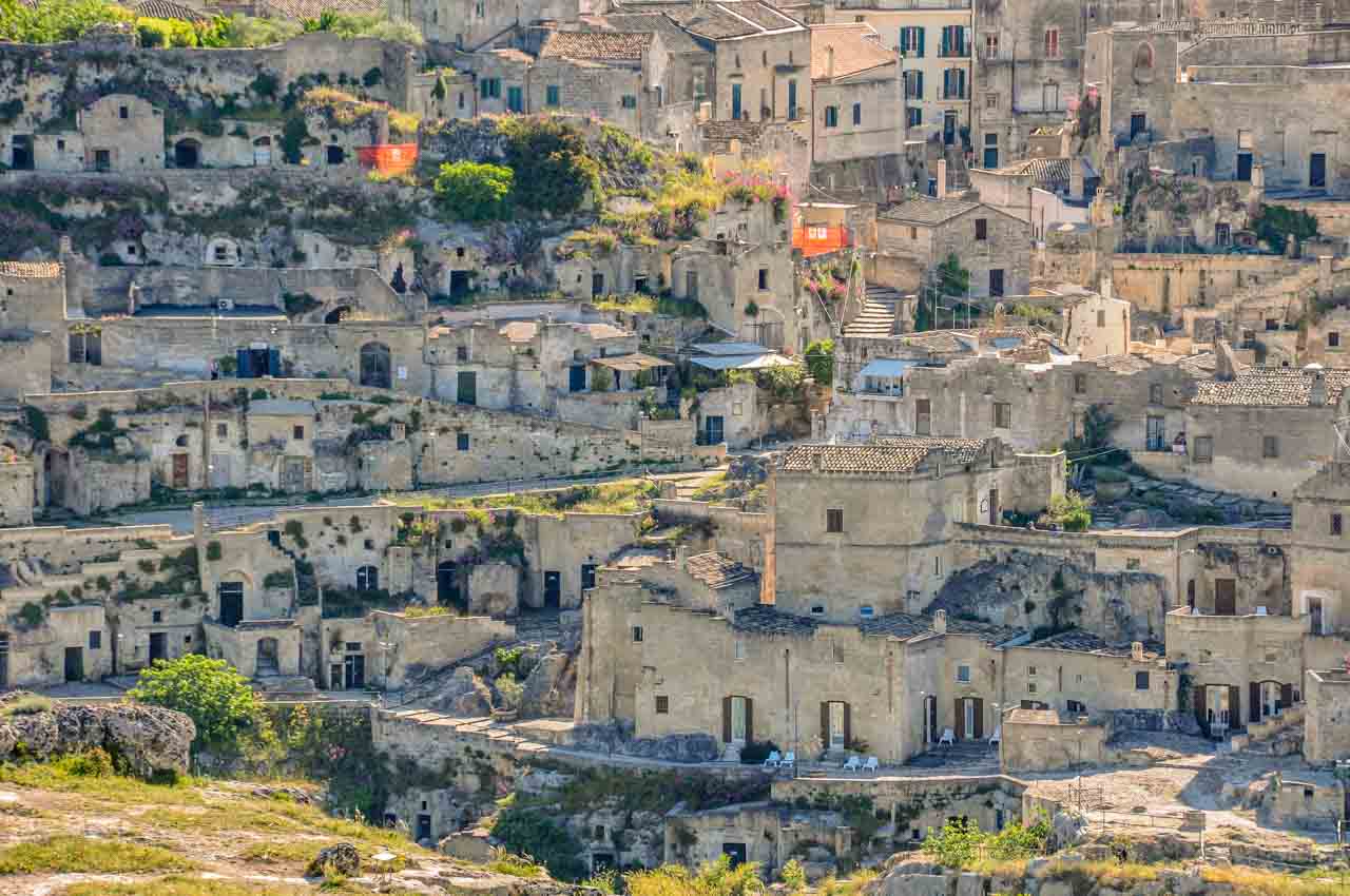
Sassi di Matera – roofs are streets, and floors are ceilings.


You would be forgiven for thinking the Sassi are a place of shadow and crampedness. But not so. The squares in the Sassi are sun-drenched open spaces flanked by cafes, shops, churches, and restaurants – great for people-watching.

A troglodyte settlement of cave houses built into the side of a hill.

Wander the Sassi di Matera.


Cave houses are viewed through a doorway.

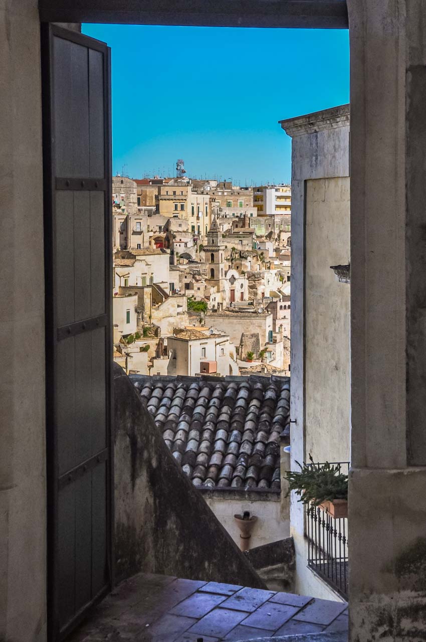
View of the Sassi through a doorway.


Cave houses are built on top of each other on the side of a hill.

World Heritage Listed Sassi di Matera.

Historical and Cultural Timeline:

2019: Matera is the European Capital of Culture.

2014: Tourism starts to take off. This was most likely due to Matera being named the 2019 European Capital of Culture, and Matera began preparations for a year of events highlighting culture and the arts.

1993: UNESCO lists Sassi di Matera as a World Heritage Site.

1986: Italian law changes and people are encouraged to return to the Sassi.

1952: Abandonment of the Sassi through the Italian Government’s forced removal of its inhabitants.

Prehistory: (approximately 9,000 years ago) People first inhabited the Sassi.

Fun facts

Several Directors have used Sassi di Matera as a film location for their movies:

  • Mel Gibson’s controversial movie, The Passion of the Christ, 2004;
  • Pier Paolo Pasolini’s The Gospel According to St Matthew, 1964; and
  • King David was directed by Bruce Beresford and starred Richard Gere in 1985.

It would seem Matera’s Sassi makes for a great ancient Jerusalem.

The 2021 James Bond movie No Time to Die also used Sassi di Matera as a film location.


Sassi di Matera is not just a destination; it’s an immersive journey through time, offering a unique blend of history, culture, and natural beauty that promises to leave a lasting impression on anyone fortunate enough to explore its enchanting streets.

The Sassi beckons, inviting you to witness a living backdrop as you explore a world where tradition meets innovation. The 15 photos you’ve seen here in my blog post are mere snapshots of the unforgettable travel experience that awaits you in person. Dare to wander off the beaten path!


Editor’s Note: I originally published this blog post in March 2019 and have updated it for accuracy and comprehensiveness.


Disclaimer: This post contains no affiliate links. All views and opinions are my own and non-sponsored. All photos are my own and remain the copyright of Just Me Travel.

© Just Me Travel 2018-2024.


Have I aroused your curiosity about Sassi di Matera? Are you inspired to visit Italy’s unique Stone City, a valuable UNESCO World Heritage Site? I love hearing from you. Join the conversation and leave a comment below.


Like this post? Save it for Later!

The image has two photos. One photo is of an old lady walking up a flight of stone steps. The second photo shows a settlement of stone houses.


The image has two photos that show a troglodyte settlement. One photo is bathed in sunlight with purple flowers and green shrubs. The second photo shows abandoned cave homes below a modern city. The image invites you to visit Italy's Sassi di Matera.


Author’s Note: Please check the latest travel restrictions before planning any trip and follow government advice.


Sign up to receive the latest in travel destinations, topics, resources and guides.


You might also like

A VENETIAN WALKABOUT – how to spend 5 perfect days in Venice, Italy [2020 UPDATED]

My self-guided walking itinerary will lead you to incredible experiences as you explore 5 of Central Venice’s 6 districts and then go island hopping.


5 Comments on 15 PHOTOS TO INSPIRE YOU TO VISIT THE UNIQUE SASSI MATERA, ITALY (2024 Updated)

A UNIQUE MONGOLIA HORSE FESTIVAL SHOWCASES IMPRESSIVE HORSE-RIDING TALENT (2023 Updated)

  No Trip to Mongolia is Complete Without Having Attended a Local Horse Festival and Witnessed Extraordinary Horseback Skills.   Dear Pip, Our trip to Mongolia is turning out to…


No Trip to Mongolia is Complete Without Having Attended a Local Horse Festival and Witnessed Extraordinary Horseback Skills.

Several me in colourful robes line up on their horses for the start of competition. They are carrying long poles with lassos on the end.

Mongolian nomads ready for competition with their uurgas (lasso poles) at a horse festival.


Dear Pip,

Our trip to Mongolia is turning out to be one unique cultural highlight after another. We spent the day sharing the excitement of a local horse festival in the Orkhon Valley, organised by Tsaidam Ger Camp, where we stayed for the night. The festival aims to preserve nomadic tradition and promote the talent and capabilities of Mongolia’s nomadic herders.

The Orkhon Valley is in Central Mongolia, about 360 kilometres southwest of Mongolia’s capital, Ulaanbaatar. The Orkhon Valley, a cultural landscape comprising 1,220 square kilometres, was designated a UNESCO World Heritage Site in 2004.

Mongolia’s history, culture, and people are intimately linked with horses, with children learning to ride almost from the day they can walk. In a country with 13 times more horses than people, I can understand how Mongolia has become known as the land of horses. Throughout the day, I came to appreciate Mongolian nomads’ strong bond with their horses and to understand how Mongolians have long been considered some of the best horse riders in the world.

After Meg shared snuff with some local elders and our guide explained what the horse festival entailed, we found a spot amongst the locals to watch and photograph the men, dressed in traditional costume, compete in several events, including horse lassoing, grabbing a lasso pole from the ground, and riding a wild, bucking horse. These events are designed to show off the Mongolian nomads’ unique horsemanship skills and the strength of their horses.

I wasn’t sure how I felt about the lassoing of stampeding wild horses. However, I learned it is an essential skill as nomadic households have many horses ridden infrequently and need to be re-broken in because they have been left to roam at will, becoming semi-wild. I needed to remind myself that this is their way of life and culture.

Being able to ride a bucking horse is par for the course with breaking-in horses, and this competition elicited shouts of encouragement from the crowd and laughter when horse and rider parted ways. One man who managed to stay on his horse delighted the crowd as he and his horse disappeared into the distance.

I particularly enjoyed watching the men grabbing an uurga (long pole with a lasso on the end) off the ground from a galloping horse. I was left in awe as to how they stayed on their horse because they would be well down the side of the horse, around its fast-moving legs. Their core strength must be remarkable! With all the rider’s weight on one side, how did the horse not topple over?

Some of the younger men had a competition on the side, grabbing a cigarette lighter off the ground from their galloping horse – some more successful than others. The control these young men and all other competitors had over their horses was genuinely impressive.

It was a most enjoyable, exciting day; I will take home unforgettable memories.

Love,

Joanna

Riders on horses with lassos on long poles rope stampeding horses.

Lassoing wild, stampeding horses at the Mongolian Horse Festival.


People stand around in front of a tent while watching a man fall to the ground off a bucking horse.

I bet that hurt! A competitor falls off a bucking wild horse.


A man in a colourful robe hangs on the side of his galloping horse as he picks up a stick off the ground.

Picking up an uurga (lasso on a pole) off the ground from a galloping horse.


A young man hangs on the side of his galloping horse as he picks up a cigarette lighter off the ground.

A young man picks up a cigarette lighter off the ground from a galloping horse.


Editor’s Note: I originally published this blog post in February 2019 and have updated it for accuracy and comprehensiveness.


Disclaimer: This post contains no affiliate links. All views and opinions are my own and non-sponsored. All photos are my own and remain the copyright of Just Me Travel.

© Just Me Travel 2018-2023.


Would you seek out this type of experience when travelling? I love hearing from you. Leave a comment below.


Like this post? Save it for later!

Men in colourful robes sit on a fence railing with their saddled horses behind them.


A man dressed in a colourful robe hangs on the side of his galloping horse as he picks up a pole off the ground.


Author’s Note: Please check the latest travel restrictions before planning any trip and follow government advice.


Sign up to receive the latest in travel destinations, topics, resources and guides.


You might also like


A person is fossicking for dinosaur fossils along an escarpment of the Flaming Cliffs in Mongolia's Gobi Desert.DINOSAUR FOSSIL HUNTING IN MONGOLIA’S GOBI DESERT AT THE FLAMING CLIFFS (2023 Updated)

The Flaming Cliffs are famous for the discovery of dinosaur eggs in 1923 and is one of the world’s greatest dinosaur fossil sites. Go fossicking!


A nomad and his ger

MONGOLIAN CULTURAL NORMS AND TRADITIONS – HOW TO PREVENT CULTURAL ERRORS

Cultural sensitivity when travelling is a sign of deep respect. Prevent social and cultural faux pas through ignorance. Know before you go!


8 Comments on A UNIQUE MONGOLIA HORSE FESTIVAL SHOWCASES IMPRESSIVE HORSE-RIDING TALENT (2023 Updated)

NEW ZEALAND’S FIORDLAND NATIONAL PARK – Discover 3 Spectacular Sounds

Join Me on a Visual Journey Through the Awe-Inspiring Sounds of Fiordland National Park, a Place Where Nature’s Grandeur and Serenity Intertwine.   On two recent trips to New Zealand…

Join Me on a Visual Journey Through the Awe-Inspiring Sounds of Fiordland National Park, a Place Where Nature’s Grandeur and Serenity Intertwine.


On two recent trips to New Zealand (Aotearoa), one by land and one by sea, I was fortunate to have cruised three spectacular sounds (fiords) in Fiordland National Park – Dusky Sound, Doubtful Sound, and Milford Sound. New Zealand is one of only a few places where you can see the spectacular sight of glacial-fed fiords.

My land trip involved a convoluted journey to the included overnight, scenic cruise on Doubtful Sound. But my sea trip was a cruise on a large ship, where we sailed in and out of Dusky Sound, Doubtful Sound, and Milford Sound from the Tasman Sea.

In this post, I focus on my photographs of the three sounds because, as the saying goes, a picture paints a thousand words. I feel no amount of words will do justice to the breathtaking natural beauty I experienced of Dusky Sound, Doubtful Sound, and Milford Sound.


Fiordland National Park

The Māori name for Fiordland is Te Rua-o-Te-Moko.

A partial map of New Zealand's South Island showing the fiords in Fiordland National Park

Map of the sounds in New Zealand’s Fiordland National Park (beautifulworld.com)


Fiordland National Park is located in the southwestern corner of New Zealand’s South Island. At over 1.2 million hectares and covering nearly 13,000 square kilometres, it is New Zealand’s largest national park.

Fiordland National Park is a place of extraordinary beauty, and it is home to glaciers, majestic alpine ranges, lakes, rainforests, unique flora and fauna, and 14 sounds (fiords). Dusky Sound, Doubtful Sound, and Milford Sound are three of the park’s most significant fiords.

You will have noticed I jump between ‘sound’ and ‘fiord’, and both terms are correct. However, Dusky Sound, Doubtful Sound, and Milford Sound are actually fiords as they are glacier-carved valleys filled by the sea rather than river valleys flooded by the sea. British explorers misnamed them as sounds, and the name has stuck!

Dusky Sound

The Māori name for Dusky Sound is Tamatea.

A photo of rays of light, clouds, mountains, and a body of water.

Rays of light stream through the clouds over Dusky Sound


Dusky Sound is remote and accessible by air and sea only. It is the largest of Fiordland’s 14 sounds at 40 kilometres long and eight kilometres wide at its widest. Several islands lie in the sound.

Dusky Sound is an area of stunning landscapes, with craggy mountains and hundreds of waterfalls cascading into the sound during winter (June-August) when there are higher rainfalls. It is a wildlife wonderland with seals and dolphins often sighted in the sound.

We sailed into Dusky Sound at 8.30 in the morning, with the clouds still rising above the mountains. Dusky Sound was my favourite of the three sounds as I found it to be the more dramatic. That it revealed itself only slowly added to the drama.

A visual journey through Dusky Sound

Tall peaks with low cloud cover reach a body of water

Low clouds drape the mountains of Dusky Sound.


A body of water surrounded by mountains and low cloud cover.

Dusky Sound, Fiordland National Park


Mountains line a body of water with small islands

Dusky Sound – mountains and islands


Doubtful Sound

The Māori name for Doubtful Sound is Patea, meaning “the place of silence”.

Mountains surround a body of water with small islands in the still morning

Untouched Doubtful Sound, Fiordland National Park


Doubtful Sound is the deepest (421 metres) and one of the longest (40 kilometres) of South Island’s fiords and has three arms. Doubtful Sound is a pretty waterway with its rugged landscape, verdant rainforest, and cascading waterfalls. Wildlife includes fur seals and penguins, and it is home to a permanent pod of about 70 bottlenose dolphins.

Doubtful Sound is remote, and there is no direct road access. Your only way of getting to Doubtful Sound is a bit of a journey but an adventure in itself. Starting at Pearl Harbour wharf in Manapouri, you take a cruise across Lake Manapouri to West Arm (about 50 minutes), then travel by coach over Wilmot Pass (671-metre-high) to Deep Cove in Doubtful Sound, where you board your scenic day or night boat cruise. On the drive over Wilmot Pass, the coach stops at a vantage point for a magnificent view of Doubtful Sound below. The total time travelled from Manapouri to Deep Cove is nearly two hours. There is no settlement at Deep Cove, but it is home to a small fishing fleet.

View from above of a fiord with mountains on both sides.

Looking down on Doubtful Sound from Wilmot Pass


I first experienced the remote wilderness of Doubtful Sound on an overnight cruise on the three-masted Fiordland Navigator, taking the journey described above to get to the ship. On our second day, the ship stopped the engines for 10 minutes of silence to honour Doubtful Sound’s Māori name and listen to nature.

A three-mast passenger ship docked at a wharf, with mountains in the background.

The Fiordland Navigator docked at Deep Cove Wharf in Doubtful Sound.


My second trip along Doubtful Sound was aboard a cruise ship, entering the fiord from the Tasman Sea.

A visual journey through Doubtful Sound

Mountain peaks tinged blue in the early morning light surround a body of water.

The blue tinge of early morning light on Doubtful Sound


Mountain peaks rise above a body of water

The shadows and light of Doubtful Sound


A body of water surrounded by mountains and wake in the water created by an unseen boat.

The ship’s wake creates a path through Doubtful Sound.


Milford Sound

The Māori name for Milford Sound is Piopiotahi.

Tall mountain peaks surround a body of water

Milford Sound, Fiordland National Park


Milford Sound is 16 kilometres long, with sheer cliffs and waterfalls to rival some of the world’s tallest. It is the only fiord accessible by road (around 5-6 hours from Queenstown and about three hours from Te Anau) and the most popular. You can stay in Milford Sound, with accommodation options ranging from Airbnb to a public lodge.

Milford Sound is known for the towering Mitre Peak, so called because it resembles a bishop’s mitre. The fiord is home to dolphins, fur seals, and penguins.

The naturalist onboard the Fiordland Navigator commented that Milford Sound is the most touristy of Fiordland National Park’s fiords but the most beautiful. You be the judge! Perhaps the lack of tourists in Dusky Sound and Doubtful Sound appealed to me the most. Somehow, they felt more untouched. But who am I to say? The British writer Rudyard Kipling visited Milford Sound in the 1890s and declared it ‘the eighth wonder of the world’.

A visual journey through Milford Sound

A small boat cruises through water surrounded by tall cliffs.

The cliffs of Milford Sound dwarf a boat.


Sheer mountains dwarf a waterfall and boat.

Milford Sound has many waterfalls.


A photo of a mountain shaped like a Bishop's mitre

Mitre Peak, Milford Sound


No trip to New Zealand is complete without exploring Fiordland National Park and the spectacular sight of glacial-carved fiords.

I hope these photographs have transported you to a land of untamed beauty, leaving an indelible imprint on your senses with a desire to discover for yourself. Fiordland’s sounds are a testament to the power and harmony of the natural world.


Disclaimer: This post contains no affiliate links. All views and opinions are my own and non-sponsored. All photos are my own and remain the copyright of Just Me Travel.

© Just Me Travel 2018-2022.


If you could only visit one of New Zealand’s sounds (fiords) in Fiordland National Park and getting there was no barrier, which sound would you choose and why? Leave a comment below.


Like this post? Save it for later!

A collage of two photos of mountains reaching down to a body of water. One photo shows a mountain shaped like a Bishop's mitre. The other photo shows the wake of an unseen boat.

A collage of two photos. One photo shows a river-like body of water with mountains on both sides, looking from above. The other photo shows a mountain reflected in the water.


Author’s Note: Please check the latest travel restrictions before planning any trip and follow government advice.


Sign up to receive the latest in travel destinations, topics, resources and guides.


You might also like

A view of New Zealand's snow covered Southern Alps, with Mount Cook in the background.HOW TO LAND ON A GLACIER IN NEW ZEALAND’S STUNNING SOUTHERN ALPS. Climb aboard a helicopter for a scenic flight over Fox and Franz Josef Glaciers and experience a snow landing on Franz Josef Glacier.


No Comments on NEW ZEALAND’S FIORDLAND NATIONAL PARK – Discover 3 Spectacular Sounds

A PHOTOGRAPHIC TOUR OF GEOFFREY BAWA’S GARDEN, SRI LANKA [2022 Updated]

Photos of an Astounding Untamed Garden by Geoffrey Bawa.   Geoffrey Bawa is still regarded as one of the greatest architects to have ever lived. But his genius was not…

Photos of an Astounding Untamed Garden by Geoffrey Bawa.


Geoffrey Bawa is still regarded as one of the greatest architects to have ever lived. But his genius was not confined to bricks and mortar. On Lunuganga Estate, Geoffrey’s country home in Sri Lanka, he brought together architecture, art, plants, and the odd cow to create a magnificent, controlled landscape of untamed wilderness.

Finding things to do in Sri Lanka away from the maddening crowds is an excellent reason to visit Geoffrey Bawa’s garden as it is largely undiscovered by tourists, being something different from the ‘usual’ tourist attraction.


I have my sister to thank for our visit to Geoffrey Bawa’s garden – not to be confused with Brief Garden, the former estate of Geoffrey’s older brother Bevis Bawa.

While researching things to do for our trip to Sri Lanka, that teardrop-shaped nation sitting at the bottom of India in the Indian Ocean, my sister discovered a reference to Geoffrey Bawa’s garden on his Lunuganga Estate. How could we not include a garden described as “the most seductive, passionate pleasure gardens of the twentieth century” (lunuganga.com) on our itinerary?

So, who was Geoffrey Bawa?

Geoffrey Bawa (1919-2003) was Sri Lanka’s most well-known architect and is deemed the most influential Asian architect of his time. For those architect enthusiasts reading this post, he was one of the founding fathers of the architectural style known as “tropical modernism”. Geoffrey Bawa is probably best known for designing Sri Lanka’s Houses of Parliament.

Living permanently in Colombo, Lunuganga Estate, situated on the banks of Lake Dedduwa in Bentota (midway between Colombo and Galle), was Geoffrey Bawa’s country retreat. Here, on 23 acres, he spent 50 years turning this abandoned rubber plantation (and, before that, a cinnamon plantation) into eclectic gardens of multiple shades of green.

We explored Geoffrey Bawa’s garden with the Head Curator on a 2-hour private tour.

Don’t expect to find manicured gardens of colourful flowers, neat borders, and gurgling fountains. But expect an untamed but controlled tropical wilderness of sudden vistas, intimate groves, sculptures, and wide landscapes. I found Bawa’s garden a place of peace, tranquillity, and restfulness.

Lunuganga Estate – Geoffrey Bawa’s garden

Lunuganga Estate is about 500 metres long and 300 metres at its widest. There is no spot where you can view the garden in its entirety. Instead, it is a journey from one seemingly disconnected space to another that somehow Geoffrey managed to create a cohesive whole.

Take a stroll with me on a visual tour of Geoffrey Bawa’s garden.

The Hen House

A brick and wood hen house with tile roof set amongst tropical forest.

Geoffrey Bawa’s Hen House on Lunuganga Estate.


Geoffrey Bawa famously designed Sri Lanka’s Parliament House. He then created his hen house (chicken coup) on Lunuganga Estate in the same style. Take from that what you will!

Sandela Pavilion

A glass room with large black and white floor tiles, polished wooden table, chairs and coffee table.

Sandela Pavilion


The Sandela Pavilion, also known as the Glass House, is an open, airy space and served as Geoffrey Bawa’s office. From here, he had a lovely view of the lake and could see anyone who arrived at the main gate.

The Red Terrace

A flat red earth terrace with views of a lake. with a stone wall on one side and jar on the wall

The Red Terrace with views of Lake Dedduwa


The Red Terrace derives its name from the red laterite ground surface, produced by the decomposition of the underlying rocks.

With its views of Lake Dedduwa and the Water Garden at the bottom of the hill, the Red Terrace was a favourite spot for Geoffrey to have lunch.

The Water Garden

A pond surrounded by tropical forest

The Water Garden


The Water Garden is a tropical oasis. The pond is shaped like a butterfly and is filled with pink flowering water lilies. A bench seat takes pride of place beside the pond in the shade of trees. Here Geoffrey would sit and ring the garden bell for his gin and tonic to be brought to him.

The Water Garden incorporates ornamental rice paddies stretching along the banks of Lake Dedduwa, adding to the eclectic nature of Geoffrey Bawa’s garden design.

Rice paddies beside a lake

Rice paddies on Lunuganga Estate


Sculptures around the garden

There are several sculptures around the garden.

Rusty, blue metal sundial sculpture with the head of a dog

Sundial sculpture in the Water Garden


The rusted metal sundial sculpture in the Water Garden has an air of decline and abandonment.

A stone sculpture of the face of horned pagan god, Pan.

“Hindu” Pan sculpture


The sculpture of the pagan god Pan was sculptured by one of Geoffrey’s Tamil assistants and called “Hindu” Pan by Geoffrey. No reason has been given as to why he called it such. Perhaps because a Tamil sculpted it?

Metal sculpture of a figurine with four arms

Garden sculpture


The Plain of Jars

A large black jar sitting on grass is reflected in the waters of a pond

The Plain of Jars


In a setting of sloping grassy plains surrounded by forest, the Ming dynasty-style jars that dot this part of the landscape were added here by Geoffrey.

The jars are not confined to this area of the garden but were purposefully placed by Geoffrey throughout the garden. Geoffrey Bawa had a knack for controlling the landscape without taming it.

A large black jar on the ground underneath a tree

Ming dynasty-style jar on the hill


A large black jar on the ground under a tree

A Ming dynasty-styled jar under a tree.


Jackfruit

Two Jackfruits growing on the Jackfruit tree

Jackfruit in Geoffrey Bawa’s garden


Lunuganga Estate is set in Sri Lanka’s wet tropical zone, so tropical fruits, like the Jackfruit, are not unknown and grow to large proportions.

Cinnamon Hill House

A single story orange coloured building with blue doors.

Cinnamon Hill House on Lunuganga Estate.


In a forested area on the western slope, Geoffery used Cinnamon Hill House as a studio from where he created his architectural designs. It also served as accommodation for his guests and was the last addition to the Garden.

Geoffrey Bawa’s home

A single story White House with black and white painted doors and red tile roof, partially hidden by trees and bushes.

Geoffrey Bawa’s former home.


The tour ended with walking past a most unusual windmill before the gentle climb up Cinnamon Hill for lunch on the wide veranda of Geoffrey Bawa’s former home on Lunuganga Estate, now a boutique hotel. Lunch consisted of a set menu of delicious traditional Sri Lankan curries.

A multi-storey brick windmill that looks like a castle turret

A unique windmill on Lunuganga Estate


The veranda of a home set with tables and chairs ready for lunch

Lunch on the veranda of Geoffrey Bawa’s former home.


The home sits at the top of Cinnamon Hill, allowing breathtaking views over Lake Dedduwa. Lunch was a visual and gastronomic pleasure.

The gardens are open to the public, and the buildings on the estate operate as boutique country accommodation

Guided tours of the gardens run daily: 9.30 am, 11.30 am, 2.00 pm, and 3.30 pm. A reservation is essential if you want to have lunch whilst visiting the estate. Check the Geoffrey Bawa Trust website for garden tour prices and how to book lunch.

Guests staying on Lunuganga Estate can wander the gardens without needing a guided tour.

How to get from Colombo to Lunganga Estate, Bentota

The drive from Colombo to Lunuganga Estate will take about 1 hour and 14 minutes, for a distance of 83.9 kilometres.

But what if I don’t have a car? Can I still get to Geoffrey Bawa’s garden?

You have three options if you don’t have the means to drive to Lunuganga Estate: train, bus, or taxi. The train is the fasted option, taking 1 hour and 6 minutes and costing AU$5 – AU$7, including the taxi fare from Aluthgama Station to the estate. For a taxi from Colombo to Lunuganga Estate, the most expensive option, expect to pay AU$30 – AU$40.

Refer to the website, Rome2rio, for details on schedules, costs, routes, travel times, and operators.


Geoffrey Bawa’s garden is not a formal garden in the European sense. Nor is it a major tourist attraction. But that’s what makes it interesting and a bucket list thing to do in Sri Lanka.


Editor’s Note: I originally published this blog post in February 2019 and have updated it for accuracy and comprehensiveness.


Disclaimer: This post contains no affiliate links. All views and opinions are my own and non-sponsored. All photos are my own and remain the copyright of Just Me Travel.

© Just Me Travel 2018-2022.


Please leave a comment below to share your thoughts. Would you visit Lunuganga Estate and Geoffrey Bawa’s garden if visiting Sri Lanka?


Like this post? Save it for later!

A pond surrounded by tropical forest. The writing on the image states, Visit Geoffrey Bawa's Garden in Sri Lanka.

A photo of a house veranda set with tables and chairs for lunch. The writing on the photo states, Have lunch at Geoffrey Bawa's Garden in Sri Lanka.


Are you looking for more ideas on destination Sri Lanka? Then don’t miss these posts:

WHAT IS THE MISSING TRUTH ABOUT CLIMBING SRI LANKA’S LITTLE ADAM’S PEAK

FIRST 24 HOURS IN GALLE FORT, SRI LANKA

WALKING THE RAILWAY LINE FROM ELLA TO DEMODARA, SRI LANKA

WALLAWWA – a tranquil luxury boutique hotel in Colombo City

ULTIMATE SRI LANKA ITINERARY – The best of Sri Lanka in 20 Days


Author’s Note: Please check the latest travel restrictions before planning any trip, and always follow government advice.


Sign up to receive the latest in travel destinations, topics, resources and guides.


6 Comments on A PHOTOGRAPHIC TOUR OF GEOFFREY BAWA’S GARDEN, SRI LANKA [2022 Updated]

23 GREAT PHOTO SPOTS ON THE ROAD FROM PERTH TO BROOME, AUSTRALIA

A Western Australia Road Trip from Perth to Broome is a Journey of  Unique Photo Opportunities.   In this post, I will take you to 23 great places you should…

A Western Australia Road Trip from Perth to Broome is a Journey of  Unique Photo Opportunities.


In this post, I will take you to 23 great places you should photograph on the road from Perth to Broome. If you are travelling up Western Australia’s picturesque Coral Coast and visiting its amazing national parks, this list will provide you with some awesome holiday photography ideas.


This journey of photo spots on a road trip from Perth to Broome in Australia starts in Perth, travels up the coast, heads inland before hitting the coast again, and ends in Broome.

My post is about great photo opportunities for you on the road from Perth to Broome in Western Australia. Most are in national parks, and all are accessible by 2WD. I hesitate to say “easily” accessible because the unsealed roads through much of Karijini National Park were severely corrugated when our 4WD tour bus travelled on them. Our ‘4WD’ had the body of a bus on a truck chassis, which would best be described as a bus on steroids. I don’t know how often the roads are graded through Karijini National Park, but they gave new meaning to the saying, shaken, not stirred.

The post is not about hikes you can take through the national parks, of which there are many, nor about things you can do or places to stay. It’s not even about how to get from place to place, although the maps above show you where the photo spots are in relation to each other and their location within Western Australia. In other words, this post is not an itinerary but a guide to where you can find great photo spots between Perth and Broome.

The photos have been included on this list not because they are a tourist attraction, which they are, but because they provide 23 great photo opportunities to create special holiday memories that should not be missed.

I use two cameras for all my travel photos – a Nikon D7200 DSLR camera and an iPhone 12 Pro. whichever is handy at the time.

Many of the photo spots in this post are in national parks. As I was on an escorted tour with APT, I was not concerned with park fees, infrastructure, or other relevant information. However, Western Australia’s Parks and Wildlife Service is the official site for all the information you need on the State’s national parks.

Many paths to lookouts and photo spots, whether inside national parks or not, are unsuitable for people with mobility issues. I say that with confidence as a few people on the escorted group tour had mobility issues and missed out on seeing several of the photo spots below.

Scroll through the photo spots at your leisure or jump straight to the photo spot you want to see.

Perth

View of a city with new glass buildings and old colonial-style buildings

Perth cityscape


Perth is a city with many spots worth photographing – beautiful parks, attention-grabbing street sculptures, striking architecture, white sand beaches, vibrant river life, and more. Perth deserves at least spending a few days there.

I spent ten days in Perth and discovered many things to do unique to this beautiful city sitting on the Swan River. You can explore the world’s largest city park, see the happiest animal on earth, marvel at a wave-shaped rock in the middle of nowhere, photograph the largest dam mural in the world, and chime the world’s biggest musical instrument. You will find these activities, and more, in my post on 7 Top Day Trips And Things To Do In And From Perth. – all suggested from my own experience as a solo traveller.

The Pinnacles Desert, Nambung National Park

Many rock pillars standing in yellow sand

The Pinnacles, Pinnacles Desert, Nambung National Park


At the southern gateway to Western Australia’s Coral Coast along the Indian Ocean Drive, the Pinnacles Desert is located within Nambung National Park, approximately 200 kilometres north of Perth, near the coastal town of Cervantes.

The Pinnacles are natural limestone structures formed approximately 25,000 to 30,000 years ago after the sea receded and left deposits of seashells. Over time, coastal winds removed the surrounding sand, leaving the pillars exposed to the elements. There are thousands of pinnacles in the Pinnacles Desert, with some reaching as high as 3.5 metres.

You can view the Pinnacles from the lookout (a paved path from the car park), drive or walk the 4-kilometre Pinnacles Loop or simply meander through the Pinnacles Desert, taking all the photos you want of this fascinating, otherworldly landscape.

Z Bend Lookout, Kalbarri National Park

A photo of a river flanked by high cliffs

Murchison River Gorge view from Z Bend Lookout in Kalbarri National Park


Kalbarri National Park surrounds the lower reaches of the Murchison River, which has carved a magnificent 80-kilometre gorge through the red sandstone.

The Z Bend Lookout reveals dramatic views of the zig-zag section of the Murchison River Gorge. The gorge below the lookout forms the middle part of the ‘Z Bend’. Fractures within the red Tumblagooda Sandstone form this unusual shape.

Z Bend Lookout is a 1.2-kilometre return walk from the car park along a sandy path with stone steps. Walking back up is a decent cardio workout.

Kalbarri Skywalk, Kalbarri National Park

A viewing platform hangs out over a gorge

The Kalbarri Skywalk provides an excellent view over Murchison River Gorge


The Kalbarri Skywalk consists of two cantilevered viewing platforms that hang in mid-air 100 metres above the gorge. They provide stunning views of the Murchison River Gorge and its extraordinary surrounding landscape.

Just walking out on these platforms was a unique experience in itself. To be then confronted with the views on offer was truly breathtaking.

The Kalbarri Skywalk is about 150 metres from the car park on a flat, paved path.

Nature’s Window, Kalbarri National Park

A river is seen through a hole in the cliff

Murchison River Gorge viewed through a natural rock window


Forces of nature have carved through layered sandstone to create a rock formation that frames the Murchison River below.

It is a moderate, one-kilometre return walk beginning with a flight of stairs from the lookout at the parking area. Just remember, you need to walk back up those stairs!

Beware: Access to Nature’s Window is not for the faint-hearted as there is nothing, except your excellent balance, to stop you from falling over the cliff’s edge.

Ross Graham Lookout, Kalbarri National Park

A photo of a river flowing through a gorge

Murchison River Gorge viewed from Ross Graham Lookout in Kalbarri National Park


Ross Graham was the first headmaster of Kalbarri Primary School. He was a devoted conservationist who aided in the exploration of the Murchison River. He died in 1967, aged 31 years.

The Ross Graham Lookout offers a limited but picturesque view of the Murchison River. The lookout is 100 metres from the car park along a rocky track.

Beware: There are no safety barriers on the cliff edge at the lookout.

Abrolhos Islands, Houtman Abrolhos Islands National Park

A group of inhabited islands in the ocean

A scenic flight over Abrolhos Islands


Houtman Abrolhos Islands National Park is a marine archipelago of 210 islands lying 60 to 80 kilometres off Western Australia’s mid-west coast, between Geraldton and Kalbarri.

You will need to take a scenic flight to take advantage of this photo spot of the islands and the coral reefs surrounding them. Our scenic flight was with Nationwest Aviation from Kalbarri Airport.

A couple of passengers saw migrating whales. I was on the wrong side of the plane!

Eagle Bluff Lookout, Francois Peron National Park

Rugged coastline and sandy bays

View from the Eagle Bluff boardwalk


Eagle Bluff is approximately 20 kilometres south of Denham in the UNESCO Shark Bay World Heritage Area.

A 400-metre boardwalk along the cliff edge offers stunning views of the rugged coastline, small islands, and coastal bays fringing the Indian Ocean and provides the opportunity to spot wildlife like ospreys, dugongs, dolphins, turtles, sharks, and rays.

Monkey Mia Conservation Park

A beach with mangroves, white san and red sand dunes

Monkey Mia Conservation Park


Monkey Mia Conservation Park is 25 kilometres northeast of the coastal town of Denham.

Monkey Mia is, first and foremost, famous for feeding wild dolphins that visit the beach at Monkey Mia Dolphin Resort. However, for me, the area was about mangroves, red dunes, sapphire blue waters, and white sandy beaches on the Indian Ocean.

Facing the jetty from the beach at Monkey Mia Dolphin Resort, where I was staying, I walked around a couple of headlands to discover the spot pictured above. It possibly holds greater significance for me as I was seeking solitude away from the resort crowds. There was not another person as far as the eye could see.

Shell Beach, Francois Peron National Park

A photo of entirely small white shells

The cockle shells of Shell Beach


Shell Beach on Western Australia’s Coral Coast is 45 kilometres from Denham within the UNESCO Shark Bay World Heritage Area. The beach consists of trillions of tiny white shells up to 10 metres deep, forming a beach stretching 120 kilometres. There is no sand, only shells.

Shell Beach is one of only a handful of places on earth where shells replace sand. The shells are from the tiny Fragum Cockle, also known as Hamelin or Shark Bay Cockle. They reminded me of the pipi shells I always saw on Sydney beaches.

In the early 1900s, the shells were quarried and hard-packed, cut into blocks and used to construct buildings. There is still evidence of the historic Shell Quarry.

Coral Bay, Ningaloo Coast

A photo of different types of corals

Coral garden on Ningaloo Reef at Coral Bay


The UNESCO World Heritage-listed Ningaloo Reef is a 240-kilometre-long stretch of coral gardens with over 200 coral species and clear, turquoise waters that are home to whale sharks, manta rays, dugongs, sea turtles, and reef fish.

Ningaloo Reef is Australia’s second largest reef, the world’s largest fringing reef, and includes one of the longest near-shore reefs in the world. At Coral Bay, the reef is just 500 metres from the shore.

I took this photo of the coral through a glass-bottom boat.

The Vlamingh Head Lighthouse

A lighthouse on a hill with view to the ocean

Vlamingh Head Lighthouse


Just 17 kilometres from Exmouth, Vlamingh Head Lighthouse is inside the UNESCO Ningaloo Coast World Heritage Area and Ningaloo Marine Park.

The lighthouse is a vantage point for magnificent views of the Indian Ocean, Ningaloo Reef, and Cape Range National Park. It is also one of the few places in Australia where you can watch both sunrise and sunset over the ocean.

Yardie Creek Gorge, Cape Range National Park

A river is framed by high red cliffs and green shrubs

Yardie Creek Gorge


In Cape Range National Park, which, in turn, is inside the Ningaloo Coast World Heritage Area and adjacent to Ningaloo Marine Park, Yardie Creek Gorge is a day trip from Exmouth.

Yardie Creek Gorge was reminiscent of the gorges I visited in Western Australia’s Kimberley region in 2021, where I say I lost my heart. Dramatic, sheer red cliff landscapes are a drawcard for me.

If you are curious to learn where I must return to pick up my heart, read my post on 7 Gorges in the Kimberley.

A cruise on Yardie Creek through the gorge is an opportunity to see and photograph wildlife in their natural environment. I saw many threatened black-flanked wallabies, a goanna sunning itself, and an osprey nest known to be over 100 years old (but no osprey).

A small wallaby sitting in a low-ceilinged cave

The threatened Black-Flanked Wallaby


The black-flanked wallaby must be one of the most agile marsupials on Earth, given the crevasses and caves they get in and out of on sheer cliff faces.

Turquoise Bay, Cape Range National Park

A beach of white sand and turquoise-coloured water

Turquoise Bay


Inside Cape Range National Park and Ningaloo Coast World Heritage Area, Turquoise Bay, approximately 63 kilometres from Exmouth, is described as a slice of paradise, where white sand beaches give way to its famous, crystal-clear waters.

Turquoise Bay is one of Western Australia’s best beaches and is consistently voted among the top three beaches in Australia. It took out the number 1 beach in the South Pacific and third spot in the Top 25 Beaches in the World in Tripadvisor’s 2022 Traveller’s Choice Awards.

Joffre Gorge, Karijini National Park

Looking down a gorge to a curved waterfall dropping into a pool

Joffre Gorge viewed from the lookout


Set in the Hamersley Range in the heart of the Pilbara and offering spectacular, rugged scenery and ancient geological formations, Karijini National Park is the second largest park in Western Australia.

Joffre Gorge is spectacular with its steep red cliffs and 50-metre drop waterfall. Its remarkable curved waterfall forms a natural amphitheatre.

The Joffre Gorge Lookout, where I took this photo, is a 240-metre return walk from the car park. Rock steps take you down to the lookout.

Kalamina Gorge, Karijini National Park

A small waterfall runs over red tiered rocks

The waterfall in Kalamina Gorge


Kalamina Gorge is the shallowest of the gorges in Karijini National Park and is not among the largest, but it is one of the prettiest.

The lookout is 75 metres from the car park along a gravel path with a series of natural rock steps. On the morning I visited Kalamina Gorge, some of the track was eroded, and there were many loose stones.

Beware: The lookout has no safety railing.

It is a steep track with uneven stone steps to the base of the gorge, where a small waterfall drops into a permanent pool. I took the photo above from the bottom of the gorge.

Fortescue Falls (Jubula), Karijini National Park

Water cascades over red rock terraces in to a pool below and is surrounded by forest

Fortescue Falls in Karijini National Park


Fortescue Falls in Dales Gorge is one of Karijin National Park’s few permanent waterfalls. Spring-fed, the falls cascade more than 20 metres down a series of natural rock steps before finishing in a pool.

Fortescue Falls Lookout is 150 metres from the car park on a flat paved path. The lookout provides excellent views of the 100-metres-deep Dales Gorge and Fortescue Falls. Access to the bottom of Fortescue Falls is via 200 metal steps with railings. There are seats at regular intervals as you make your way down and back up.

Fern Pool (Jubura), Karijini National Park

A small waterfall drops into a pool and is surrounded by forest

Fern Pool


From Fortescue Falls, you can take the 600-metre return track to Fern Pool, a picturesque swimming hole with a waterfall.

The dirt track required some navigation of rocks and is muddy and slippery (as I discovered) after rain.

Circular Pool Lookout, Karijini National Park

A pool of water at the bottom of a deep hole surrounded by red cliffs and trees

Circular Pool viewed from the lookout


Still in Dales Gorge in Kirijini National Park, Circular Pool is an impressive sight viewed from the lookout.

Marble Bar

A red-coloured hill is reflected in a river with rocks in the foreground

Marble Bar Pool, Coongan River


Marble Bar is said to be the hottest town in Australia. So, what better way to cool off than at this pretty spot on the Coongan River?

Marble Bar is well known for its extremely hot weather, with a mean maximum temperature second only to Wyndham, also in Western Australia.

According to the Australian Broadcasting Corporation,

“Marble Bar earned the title of Australia’s hottest town when it recorded the longest heatwave – 160 days over 37.7 degrees – in 1923 and 1924.

It is still listed in the Guinness Book of Recordes. Its record for the town’s hottest Christmas was in 2018 when it reached 48 degrees.

Two days later, the Marble Bar mercury hit its record – a debilitating 49.6 degrees.

While the numbers are impressive, the Bureau of Meteorology instead crowns the Kimberley town of Wyndham as having the highest annual temperature at 36.1 degrees.”

Since my return from Western Australia, several people have commented that Marble Bar has nothing to offer; that the town is not worth visiting. I beg to differ. What do you think?

Eighty Mile Beach

A fisherman on an ocean beach

Eighty Mile Beach


Unspoilt Eighty Mile Beach is a beautiful pristine beach of white sand and turquoise water that goes on forever – for 220 kilometres, to be exact! It is the longest uninterrupted beach in Western Australia. I don’t know where the ‘Eighty Mile’ comes from, but it is obviously a misnomer.

In my opinion, Eighty Mile Beach beats Turquoise Bay hands down in the best beaches category. Picture perfect! What do you think?

Eco Beach Resort, Broome

Sunset over a beach

The sun sets over the beach below Eco Beach Resort


The first rays of the sunset at Eco Beach Resort radiate a sepia glow over the sands and ocean. The sunset just got better and better.

The next and final stop is Broome, 134 kilometres from Eco Beach Resort.

Broome

Red rocks lead to blue ocean, with a beach in the distance

Gantheaume Point, Broome, with Cable Beach in the distance


Gantheaume Point is at the southern end of Broome’s famous Cable Beach. With the reds and yellows of the sandstone cliffs against the backdrop of a deep blue Indian Ocean, every photo is perfect.

Gantheaume Point is a less-crowded alternative from Cable Beach Resort to watch the sun spectacularly set as it sinks below the Indian Ocean.

Are you wondering what else you can do in Broome? Check out my post on 15 Photos To Inspire You To Visit Broome.


Driving Western Australia’s picturesque Coral Coast and awe-inspiring national parks on the road from Perth to Broome offers many quality photo opportunities. Limiting this post to 23 photo stops was not an easy task. Don’t hesitate to stop at every scenic sight, as a memorable photo could be just moments away.


Disclaimer: This post contains no affiliate links. All views and opinions are my own and non-sponsored. All photos are my own and remain the copyright of Just Me Travel.

© Just Me Travel 2018-2022.


Please leave a comment below to share your thoughts. In your opinion, do the photo spots in this post deserve to be included? Are there other photo spots you believe are crying out to be added?


Like this post? Save it for later!

A photo of a map with a camera and mobile phone on it and a photo of a natural rock formation like a window with a view of a river.

A photo of a river with a hill reflected in the water and a photo of a beach at sunset


For more posts on Western Australia, read these:

HOW TO SEE HORIZONTAL FALLS AND EPIC TIDES, AUSTRALIA

7 TOP DAY TRIPS AND THINGS TO DO IN AND FROM PERTH, AUSTRALIA

15 PHOTOS TO INSPIRE YOU TO VISIT BROOME, WESTERN AUSTRALIA

SEE 7 BEAUTIFUL GORGES IN THE KIMBERLEY – the ultimate guide

THE ULTIMATE GUIDE TO 6 SAFE SWIMMING HOLES IN THE KIMBERLEY, AUSTRALIA


Author’s Note: Please check the latest travel restrictions before planning any trip, and always follow government advice.

No Comments on 23 GREAT PHOTO SPOTS ON THE ROAD FROM PERTH TO BROOME, AUSTRALIA

9 BEAUTIFUL BLUE MOUNTAINS WATERFALLS + PHOTOS

“Mother Nature is the greatest artist and water is one of her favourite brushes” – Rico Besserdich   During a wet summer, I took a road trip to discover and…

“Mother Nature is the greatest artist and water is one of her favourite brushes” – Rico Besserdich


During a wet summer, I took a road trip to discover and photograph as many Blue Mountains waterfalls as possible in a 5-day stay. This post is about the nine waterfalls I got to, all breathtakingly unique, and how to find them. Would you visit all or any of these waterfalls in New South Wales’s Blue Mountains? I will let my photos do the talking, and you be the judge.


By December 2021, New South Wales had come out of covid lockdown, and I needed to stretch my travel legs by taking a road trip. Having reached this conclusion, my next step was deciding where to go. At the time, New South Wales had been experiencing significant rainfall. So, I knew the Blue Mountains waterfalls would be more than a trickle and an excellent time to visit and photograph them.

My love of waterfalls began with Iguazu Falls in Argentina and was cemented with Victoria Falls in Botswana and Blue Nile Falls in Ethiopia. I feel a connection with waterfalls and am mesmerised by their power, majesty, beauty, and carefreeness. Thus, my decision to explore the Blue Mountains waterfalls was a logical one.

I had visited the Blue Mountains many times as a child but never been to any of its (according to Wikipedia) 48 waterfalls. While I am drawn to waterfalls, I wasn’t planning to visit that many. What I could see in 5 days seemed to be a good compromise. Despite the continuing rain and a pea-souper fog on one day, I discovered and photographed nine known Blue Mountains waterfalls. I say ‘known’ because the Blue Mountains Heritage Centre staff in Blackheath told me national park Rangers were finding waterfalls where none previously existed.

The Blue Mountains are renowned for incredible landscapes, undeniable scenery, and nature’s finest. Best known for the iconic Three Sisters rock formation in Katoomba, there is much to discover – lookouts with views over stunning valleys, spectacular waterfalls, historic walking tracks, Aboriginal culture, heritage villages, mountain biking, adventure sports, and camping.

Fun Fact: The Blue Mountains in New South Wales are so-called because of the blue haze blanketing the mountains created by the forests of densely populated oil-bearing Eucalyptus trees releasing droplets of oil that mix with water vapour and sunlight.

My road trip involved driving from Albury to Katoomba in the Blue Mountains, with a stopover in Sydney to visit family. I based myself in Katoomba for my five days of discovering and photographing waterfalls

Most of the waterfalls I checked out are in Blue Mountains National Park – a vast region of more than 260,000 hectares on Sydney’s doorstep and part of the UNESCO Greater Blue Mountains World Heritage Area (an area covering over one million hectares). The Blue Mountains National Park is New South Wales’ most visited national park.

It rained for much of the time I was in the Blue Mountains. But with a raincoat for myself and my camera, I was well-equipped and not deterred.

Getting to some waterfalls proved challenging because all the rain had made many tracks inaccessible, and some roads were closed. With the need, on occasion, to find alternative tracks and routes, Google maps became my new best friend.

A word of caution should you visit Blue Mountains waterfalls after significant rainfalls: Many walking tracks to the waterfalls were waterlogged and slippery due to recent and ongoing rain. So, take care. And all involved lots of steps.

Fairy Falls

A photo of a wide two-tier waterfall dropping onto rocks and surrounded by trees and shrubs.

Fairy Falls on the North Lawson Waterfall Circuit was not the most spectacular waterfall I photographed on my Blue Mountains waterfalls adventure, but it was the prettiest.

To get to Fairy Falls from the township of Lawson, turn off the Great Western Highway onto San Jose Avenue. Turn left onto Badgery Crescent and then right to resume travel on San Jose Avenue. Follow San Jose Avenue to North Lawson Park, where car parking is available. From North Lawson Park, take the Dantes Glen Walking Track to Fairy Falls.

The trek to Fairy Falls is a 400-metre return walk and well signposted. At the Fairy Falls signpost, turn off Dantes Glen Walking Track, taking the path down to the falls. However, upon returning to Dantes Glen Walking Track, I recommend you turn right and continue onto Dantes Glen before returning to North Lawson Park.

A sign showing the walking tracks to waterfalls and through the Blue Mountains National Park

Signage of walking track to Fairy Falls and Dantes Glen.


Dantes Glen

A photo of a waterfall dropping into a rock pool surrounded by ferns and other vegetation. There is a fallen tree trunk resting on the waterfall ledge.

Dantes Glen is about 200 metres further along Dantes Glen Walking Track from the turnoff to Fairy Falls (a 750-metre return walk from North Lawson Park) and well signposted.

As I approached the waterfall, a narrow wooden bridge seemed to defy safe crossing. Nevertheless, I crossed without incident while carrying a water bottle and large camera, and a daypack on my back.

From Dantes Glen, I retraced my steps back to North Lawson Park.

A wooden direction sign painted blue with whits writing and surrounded by ferns and grasses.

Adelina Falls

A photo of a waterfall dropping into a rock pool surrounded by ferns and other vegetation.

Leaving the North Lawson Waterfall Circuit, I didn’t travel far to join the South Lawson Waterfall Circuit to view Adelina Falls (signposted as ‘Adeline’ Falls).

There are four waterfalls on the South Lawson Waterfall Circuit, but I only walked to Adelina Falls. With thunder rolling around the valley and having had enough of walking up and down hundreds of steps for one day, I was eager to get to my accommodation in Katoomba.

To get to Adelina Falls from Lawson, turn off the Great Western Highway at Orient Street and onto Honour Avenue, parking at the South Lawson Waterfall Circular Walking Track carpark. Adelina Falls is a 600-metre walk from the carpark.

Katoomba Falls

A photo of a multi-tiered waterfall plunging down a cliff face and surrounded by bushland.

View of Katoomba Falls taken from the Scenic Skyway at Scenic Falls.


Located between Echo Point and Scenic World, Katoomba Falls, on the Kedumba River within Blue Mountains National Park, plunges approximately 152 metres over two main levels to the Jamison Valley below.

The best view I had of Katoomba falls was the day I joined my sister at Scenic World and took a ride on the Scenic Skyway, which travels over the top of the Jamison Valley.

We also had good views from Duke & Duchess of York Lookout, but trees obscured some sections of the falls.

A photo of a signboard of several walking tracks to waterfalls in the Katoomba area of the Blue Mountains.

Signage of walking tracks to Katoomba Falls and Katoomba Cascades


Scenic World provides perhaps the best views of the Three Sisters, the Blue Mountains National Park’s iconic landmark.

A photo of sandstone rock formations in the shape of three pinnacles.

To read the Aboriginal dream-time legend behind the Three Sisters, including an alternative tale, click here.

Katoomba Cascades

A photo of a waterfall flowing over multiple rock ledges, getting wider as the water tumbles from top to bottom.

Starting at Katoomba Falls Park on Cliff Drive, Katoomba, it is an easy, short walk to Katoomba Cascades, located a few hundred metres before the Kedumba River plunges over the cliff to the Jamison Valley below.

You can view the Katoomba Cascades from a small bridge over the river or walk right up to the cascades. I took the photo above from the rocks between the bridge and the cascades.

A map showing road and walking tracks to waterfalls, lookouts and other tours attractions in Katoomba.

Map courtesy of Aussie Bushwalking (https://www.aussiebushwalking.com/nsw/katoomba-cascades)


Wentworth Falls

A photo of a waterfall plunging over multiple levels down a cliff and surrounded by bushland.

Wentworth Falls is awe-inspiring as the Jamison Creek plummets 187 metres in multiple drops to the out-of-sight valley floor below. If Fairy Falls was the prettiest waterfall I viewed and photographed on my Blue Mountains waterfalls adventure, then Wentworth Falls was the most breathtaking, and no photo does it justice.

For the best view of the falls, continue down after Wentworth Falls Lookout (disappointing view) to Princes Rock Lookout. The walk is 20 minutes return, graded ‘easy’, with some steps. Access to the bottom of the falls was closed due to maintenance work on the path.

To get to Wentworth Falls, take the Great Western Highway to the town of Wentworth Falls, turning off the highway at Falls Road. Continue to the end of Falls Road, parking at Wentworth Falls picnic area.

Gordon Falls

Photo of a multi-tiered waterfall plunging down a cliff and surrounded by bushland.

Gordon Falls Lookout is 1.6 kilometres from the main street of the Blue Mountains town of Leura. To get there, head south on Leura Mall (main street) towards Megalong Street. Continue on Leura Mall to the end of the road (T-junction) and turn left onto Olympian Parade. The track to Gordon Falls Lookout commences at the corner of Olympian Parade and Lone Pine Avenue. It is about 163 metres along the walking trail to the lookout and includes negotiating a vertical metal ladder with handrails.

Gordon Falls is to the left of the lookout. I found it tricky getting a photo of the falls due to the angle of the lookout from the waterfall. At a drop of 200-metres, I could not see the entirety of the waterfall.

While in Leura, you must visit Leura Cascades and Leura Bridal Veil Falls

Leura Cascades

A photo of a creek cascading over multiple rock ledges, creating a waterfall.

Set in Blue Mountains National Park and surrounded by rainforest, Leura Cascades is a waterfall that tumbles down multiple rock shelves on Leura Falls Creek.

The walk to Leura Cascades starts at the Leura Cascades picnic area off Cliff Drive in Leura. However, due to road works, I could not access the picnic area. I eventually found an alternative track to Leura Cascades close to Solitude Restaurant and Cafe on Cliff Drive, near Kiah Lookout. The road at this point was closed to vehicles but open to pedestrians.

The 600-metre walk to Leura Cascades took me well over the suggested 15-30 minutes required as I spent time soaking in the views over the magnificent Jamison Valley, listening to the music of rushing water, taking heaps of photos, walking on to Leura Bridal Veil Falls, and climbing back up all the steps I had taken to get down to Leura Cascades.

A map showing road and walking tracks to waterfalls, lookouts and other tourist attractions in Leura.

Credit: Google Maps


Leura Bridal Veil Falls

A photo of a wide waterfall plunging down a rugged cliff face to the valley floor below.

Fed by Leura Falls Creek and downstream from Leura Cascades, the picturesque Leura Bridal Veil Falls was a fantastic climax to my Blue Mountains waterfalls experience!

Bridal Veil Falls is a permanent waterfall with a drop of 35 metres. The ideal times to visit are late autumn, winter, and early spring.

The day I decided to see Govetts Leap Falls (also known as Bridal Veil Falls and not to be confused with the falls in Leura by the same name), it was pea-souper fog on the drive from my accommodation in Katoomba to Govetts Leap Lookout in Blackheath. Even though at Govetts Leap Lookout I couldn’t see two feet in front of me, I decided I would walk down to the waterfall. For some reason, I figured the fog would lift the lower I descended the mountain. Not my best thinking! The fog made the descent treacherous, especially on uneven, slippery steps. When I finally got to the waterfall where it plunges over the cliff, I couldn’t see anything except the new waterfall created by the unprecedented rains the area was experiencing. It was a whiteout! For the first time, I considered the negative aspect of no one knowing where I was.

Where I stayed

For the five days I spent seeking and photographing Blue Mountains waterfalls, I based myself at Lilianfels Blue Mountains Resort & Spa in Katoomba, in the heart of the World Heritage Listed Blue Mountains National Park. This 5-star resort, 90 minutes from Sydney, is set in two acres of gardens overlooking the Jamison Valley.

Fine dining, spa treatments, high tea, and a large, comfortable room made Lilianfels the ideal place to come ‘home’ to after a day of trekking.

A photo of a room in a luxury hotel, showing the bed, cupboard, couch, desk and chair.

My room in Lilianfels Blue Mountains Resort & Spa


The nine Blue Mountains waterfalls I visited in December are just the tip of the iceberg. There are many more waterfalls to explore in the Blue Mountains, and I still have 39 to discover!

My focus on this road trip was on the waterfalls located in the Blue Mountains. But there is more to the Blue Mountains than just waterfalls. It is a playground for a variety of activities and a must-visit area.

Important Note: You must check the NSW National Parks and Wildlife website for park alerts to avoid disappointment and dangerous situations. Alerts can include track and road closures, fire bans, and safety alerts.


Disclaimer: This post contains no affiliate links. All views and opinions are my own and non-sponsored. Unless expressly stated, all photos are my own and remain the copyright of Just Me Travel.


Please leave a comment below to share your thoughts. How can you not love waterfalls! Which waterfall most inspires you to visit the Blue Mountains?


Like this post? Save it for later!

A picture of two waterfalls

A picture of two waterfalls


Are you looking for more waterfalls? Read these related posts.

Photo of a waterfall with a rainbow reflected on the rock cliff face.

SEE 3 OF THE BEST WATERFALLS IN THE SOUTHERN HIGHLANDS, NEW SOUTH WALES


A photo of multiple waterfalls taken from the air while in a helicopter and looking past the pilot.

THE SMOKE THAT THUNDERS FROM MY CAMERA’S PERSPECTIVE


Author’s Note: Please check the latest travel restrictions before planning any trip, and always follow government advice.

© Just Me Travel 2018-2022.


No Comments on 9 BEAUTIFUL BLUE MOUNTAINS WATERFALLS + PHOTOS

THE ULTIMATE GREAT OCEAN ROAD PHOTO TOUR – A Fantastic 5 Day Trip

Experience One of Australia’s Most Iconic Road Trips Driving Victoria’s Great Ocean Road.   The Great Ocean Road is Australia’s most famous coastal drive and one of the best road…

Experience One of Australia’s Most Iconic Road Trips Driving Victoria’s Great Ocean Road.


The Great Ocean Road is Australia’s most famous coastal drive and one of the best road trips in the world. Famed for its stunning scenery, what better way to show you the natural phenomena, incredible wild views, and beauty of the Great Ocean Road than through the photographs I took on a photo tour road trip. Enjoy!


Victoria’s Great Ocean Road was placed on the Australian National Heritage list in April 2011 as a place of outstanding national heritage significance. The 242-kilometre Great Ocean Road follows the stunning coastline of Victoria’s southwest from Torquay to Allansford. The road winds along clifftops beside breathtaking headlands, down onto the edge of beaches, across river estuaries and through rainforests, offering ever-changing diverse landscapes and views of Bass Strait and the Southern Ocean.

The Great Ocean Road was built by returned soldiers between 1919 and 1932 and dedicated to soldiers killed during World War l. The road is the world’s largest war memorial.

To take a road trip along the Great Ocean Road is a drive I have wanted to do for many years, but something always got in the way. So, when I came across the Great Ocean Road Photo Tour with Mark Gray Photography, I could think of no better way to combine my desire to drive the Great Ocean Road and my passion for travel photography.

As a keen amateur photographer, I often seek out photography tours around the world. I firmly believe I can never stop learning and what better way to learn and master landscape photography than out of the classroom with a professional photographer by your side guiding you along the way.

Mark Gray Photography’s tours are suitable for amateur to semi-professional photographers and are limited to 6-8 participants, ensuring everyone gets plenty of individual tuition at each location from the accompanying professional and experienced photographer. The Great Ocean Road Photo Tour locations, accommodation, and meals were well researched by Mark Gray Photography, with appropriate scheduling across the five days.

Great Ocean Road Photo Tour route

A map of southern Victoria showing the Great Ocean Road route

Great Ocean Road photo tour route from Melbourne return (Google Maps)


The pickup point for our Great Ocean Road Photo Tour was in Melbourne outside St Paul’s Cathedral, near Flinders Street Railway Station.

Our route over the five days took us along the Great Ocean Road through the Victorian towns of Geelong, Torquay (the start of the Great Ocean Road), Anglesea, Lorne, Apollo Bay, Port Campbell, Allansford (the end of the Great Ocean Road), Warnambool, and on to Port Fairy (our final stop). The return trip to Melbourne from Port Fair on day five, after a sunrise shoot, breakfast, and photo critiquing session, was via Colac, where we stopped for lunch.

The photos below are shown in the order in which they were seen and taken, giving a visual journey along the spectacular Great Ocean Road.

Lower Kalimna Falls, Great Otway National Park

A photo of a waterfall dropping into a rock pool surrounded by ferns and other vegetation.

Leaving from Sheoak Picnic Area near Lorne in the Great Otway National Park, the six-kilometre return walking track to Lower Kalimna Falls through the creek valley follows the old trolley way used many years ago for hauling timber to Lorne.

Lorne Suspension Bridge

A picture of a foot bridge over a river and sand with the ocean in the background

The Lorne Suspension Bridge is a timber footbridge over the Erskine River near its mouth. An iconic landmark of Lorne, the bridge was completed in 1937.

Redwoods of the Otway Ranges

A photo looking up into the canopy of tall, straight trees.

Beech Forest in the Great Otway National Park is home to a thriving small, sheltered grove of Coastal Redwoods – the world’s tallest tree species. Towering on the river flat at Aire Valley Plantation, these redwoods were planted in 1936 by Victorian foresters for experimental purposes. They were never cut down, and although still in their infancy growth phase, they now stand about 60 metres high. Even though ‘babies’, their height as they reach for the sky still left me in awe of the sight.

It was very peaceful walking through the grove as I listened to the rippling of the water from the river flowing beside the grove of redwoods.

There is a picnic area across the road from the redwoods.

Hopetoun Falls, Great Otway National Park

A photo of a waterfall with trees in front of it.

Deemed by some as the most beautiful waterfall in Victoria, Hopetoun Falls in Beech Forest plummets 30 metres into the Aire River. Take in the view from the upper platform or descend around 200 stairs to the bottom of the falls.

The Twelve Apostles, Port Campbell National Park

A photo of limestone stacks along a coastline and the ocean with a pink tinge from the setting sun

The setting sun turns the ocean pink at the Twelve Apostles


A photo of four limestone stacks in the ocean off the coast

The rising sun is reflected on the limestone stacks of the Twelve Apostles


The Twelve Apostles is one of Australia’s iconic landmarks and the most photographed along the Great Ocean Road.

The Twelve Apostles is a collection of limestone stacks off the shore of Port Campbell National Park, formed by erosion over millions of years. The harsh and extreme weather conditions from the Southern Ocean along Victoria’s coast gradually erode the soft limestone to form caves in the cliffs, which become arches that eventually collapse, leaving rock stacks. Just as the winds and rough waves create the stacks, they also destroy them.

Despite the name, there were never twelve rock stacks, only ever nine. The nine became seven (according to Parks Victoria) after one collapsed in 2005 and another in 2009.

The Twelve Apostles was originally known as Sow and Pigs, with Muttonbird Island being the sow and the stacks being the pigs. The name change was solely due to marketing purposes, as the ‘Twelve Apostles’ had a better ring to it.

London Bridge, Port Campbell National Park

A photo of a limestone arch in the ocean that was a bridge to the mainland before it collapsed.

The arch of London Bridge was once connected to the mainland by a natural span that people could walk across, hence the name. The span collapsed on 15th January 1990, disconnecting the arch from the mainland forever. At the time of the collapse, two tourists were stranded on top of the arch and had to be rescued by helicopter. No one was injured in the event.

The Grotto, Port Campbell National Park

A picture of a steps leading down to a rocky coastline with the ocean in the background. One of the rock formations has an arch with a view to the ocean.

The Grotto, nine kilometres west of Port Campbell, is a cave, sinkhole, and archway all in one. The Grotto is a natural phenomenon formed over millions of years of crashing waves and high winds eroding the rocks, resulting in a caved sinkhole within the limestone cliffs.

You can reach the bottom via a wooden staircase that winds down the cliff face from the viewing platform at the top.

Sandy Cove, Bay of Islands Coastal Park

A picture of limestone stacks (rock formations) sitting in the ocean off the beach.

Characterised by offshore limestone rock stacks, Sandy Cove is a hidden gem along the Great Ocean Road.

Moyne River boat moorings, Port Fairy

A photo of boats in a river surrounded by houses.

Port Fairy is a historic fishing town located on the Moyne River.

Griffith Island Lighthouse, Port Fairy

A photo of a lighthouse on the edge of the ocean and surrounded by rocks

Sunset shoot of Griffith Island lighthouse


Griffith Island Lighthouse is situated at the end of a 400-metre walk along the causeway from Martin’s Point in the historic town of Port Fairy. It was built in 1859 and saw the last lighthouse keeper in the 1950s when the light, visible over 19 kilometres out to sea, was automated. The lighthouse is still fully operational, guiding ships into the Moyne River.

Port Fairy groynes

A photo taken at sunrise of timber fencing on the beach and leading into the ocean.

Sunrise shoot of the timber groynes at East Beach, Port Fairy


Groynes are structures (usually made of wood, concrete, or stone) built out into the sea from a beach to control erosion and drifting. Port Fairy’s groynes were placed at the southern end of the East Beach to stabilise the sand that had been eroding.

Tip: Fingerless gloves would be a good investment for sunrise shoots.

Where we stayed

I recommend the accommodation chosen by Mark Gray Photography on our Great Ocean Road Photo Tour.

On our five days / four nights trip, we stayed one night in Apollo Bay, two nights in Port Campbell, and one night in Port Fairy.

Seafarers Getaway, Apollo Bay, is situated opposite a private beach with all accommodation offering uninterrupted beach and coastal views. I had a well-equipped Beach Studio Unit with a furnished front deck and spectacular views of the breaking waves on the sand. The only downsides were six wall pegs in place of a wardrobe – okay for one night but would be annoying if staying longer – and the rug-less tile floors, which are great in summer but cold on the feet in winter.

Southern Ocean Villas, Port Campbell, is luxury accommodation on the edge of Port Campbell National Park and only a five-minute drive to the Twelve Apostles. Each villa is fully self-contained with two or three bedrooms, an open-plan kitchen and lounge/dining area, laundry, and an outdoor deck with table and chairs. While the bedrooms were dark (not an issue), the living area was light and airy.

Victoria Apartments, Port Fairy, is in the heart of the township of Port Fairy. I stayed in a one-bedroom suite, but other accommodation types are available. The suite’s living area was open planned, but the kitchenette was tiny. However, its winning features were a separate bedroom and a private courtyard. The accommodation was small and a bit cramped but adequate for a short stay for one person.

The 5-day Great Ocean Road Photo Tour with Mark Gray Photography was not a holiday but a dedicated photography workshop and is advertised as such. Our days were long and busy, often starting at sunrise, with little time to relax. But it was a unique way to visit the Great Ocean Road’s fantastic attractions and certainly met my long-term desire to ‘see’ the Great Ocean Road. Furthermore, I learned so much about my camera and landscape photography and came away with photos I am proud of.

You don’t have to be a photographer to appreciate the spectacular scenery and landscapes that the Great Ocean Road offers up at every turn. Take your time to discover and explore this most iconic Australian road trip along Victoria’s rugged southern coastline.

Disclaimer: This post contains no affiliate links. All views and opinions are my own and non-sponsored. All photos are my own and remain the copyright of Just Me Travel.

© Just Me Travel 2018-2022.

Please leave a comment below to share your thoughts. Has this post aroused your interest to take a road trip along Victoria’s Great Ocean Road?


Like this post? PIN it to save for later

A picture with two images. One image is of rock stacks in the ocean near the coast. The second image is of timber groynes on a beach.


A picture with two images. One image is of an arch rock formation in the ocean near the coast. The second image is of a lighthouse.


Related posts

Australia lends itself to great road trips. Read and save the following posts for more road trips around Victoria.

> THE COMPLETE GUIDE TO ROAD TRIPPING VICTORIA’S SILO ART TRAIL [2021 UPDATED]

> UNIQUE SILO ART CELEBRATES LOCAL COMMUNITIES AND FAUNA [2021 UPDATED]

> 3 OF THE BEST THINGS TO SEE AND DO IN ROCHESTER, VICTORIA [2021 UPDATED]

> WYMAH FERRY BORDER CROSSING, LOCAL HISTORY, VALLEY VIEWS – the best day trip guide

Author’s Note: Please check the latest travel restrictions before planning any trip, and always follow government advice.

No Comments on THE ULTIMATE GREAT OCEAN ROAD PHOTO TOUR – A Fantastic 5 Day Trip

OUIDAH VOODOO FESTIVAL IN BENIN – a joyous celebration with 13 photos to inspire [2021 UPDATED]

An Annual Celebration Not to Be Missed is Benin’s Voodoo Festival in Ouidah   Picture colour, music, singing, dancing, and a joyous party attracting national and international visitors. This is…

An Annual Celebration Not to Be Missed is Benin’s Voodoo Festival in Ouidah


Picture colour, music, singing, dancing, and a joyous party attracting national and international visitors. This is not Carnival in Rio de Janeiro or Venice. Add religion and culture, and you have Benin’s Voodoo Festival in Ouidah. With 13 photos to inspire your curiosity, wanderlust, and travel plans, join me in my experience of Benin’s Voodoo Day national celebration.


Voodoo Day in Benin falls on January 10 each year. It is a national holiday celebrating the country’s heritage of the West African religion of Voodoo.

Benin (officially the Republic of Benin) is a sliver of a nation in West Africa on the Atlantic Ocean. It borders Togo to the west, Nigeria to the east, and Burkina Faso and Niger to the north. Ouidah is a city on Benin’s narrow strip of coastline and was the ancient port of the slave trade.

An image of a map of West Africa

Map of West Africa


Attending Benin’s Voodoo Festival in Ouidah was my primary reason for travelling to West Africa.

Voodoo is one of Benin’s official religions, while Ouidah is considered the birthplace of Voodoo. It is probably one of the most misunderstood religions in the world. West African Voodoo is a complex religion rooted in healing and doing good to others. It is not the stuff of Hollywood – of witchcraft and black magic or sticking pins in dolls.

I must admit it was curiosity that fed my travel plans to include the Voodoo Festival in Ouidah. I wanted to witness this annual celebration of Benin’s heritage and traditional culture and to experience a unique festival.

My participation at the Voodoo Festival commenced with a visit to Ouidah’s Temple of Pythons – one of Voodoo’s most revered places and home to some 60 pythons. The pythons are a significant symbol for followers of Voodoo. They are not feared but are revered and worshipped. These pythons were said to be docile, which was just as well because they roamed freely. It was here, through a break in the trampling crowd, that I momentarily sighted the Voodoo Pope who had come to pay homage at the Temple of Pythons.

a group of women dressed in multi-coloured clothing and each wearing many bead necklaces.

Female Voodoo devotees at the Temple of Pythons


From the Temple of Pythons, the Voodoo Pope led a procession along the historical, 3-kilometre Slave Road to the ‘Door of No Return’ (of slave trade infamy) on Ouidah’s beach on the Atlantic coast. It was on this stretch of sand that the celebrations of the Voodoo Festival truly got underway.

And what a celebration!

With the dignitaries’ speeches over (this took over an hour), it was party time. But first, the spirits and Voodoo gods needed to be appeased with the sacrifice of a goat. The Voodoo Pope carried out this ritual behind a circular wall of blue plastic away from public view. Animal sacrifice is a fundamental element in Voodoo. No Voodoo ceremony is worth its salt without an animal sacrifice in exchange for favours from the spirits.

Immediately following the sacrifice, the Voodoo Pope made his way to his throne in the shadow of the Door of No Return. I say ‘throne’ because the festival hosts referred to him as “His Majesty the Pope”.

A seated group of men and women dressed in multi-coloured clothing.

The Voodoo Pope (in blue robes) on his throne


With the Voodoo Pope seated, the atmosphere changed. The speeches gave way to vibrant displays of dancing and the throbbing of drums. I witnessed ‘exorcisms’ in which a seemingly possessed person would run away from a group of people, only to be caught, dragged to the ground, and sprinkled with powder. The crowd became particularly excited when coloured haystacks appeared, spinning around the grounds. I learned these ‘haystacks’ are Voodoo spirits known as Zangbeto and are the traditional Voodoo guardians of the night – the Nightwatchmen. They are the unofficial police force and dispensers of justice. I did not envy the human police who battled to keep the crowds from encroaching on dancers and Voodoo spirits.

With so much going on around me, I wandered around aimlessly. I didn’t know which group to stay and watch or where to go next. But I was intent on seeing it all. I moved around the festival for a couple of hours until I decided it was time to sit down and people watch.

Overall, the celebration at the Voodoo Festival in Ouidah was a hive of activity in which people would swarm from one dance display to another. A kaleidoscope of colour from the attire worn by attendees and a cacophony of noise from the frantic pounding of drums dominated the festival. The crowd was buzzing.

But perhaps, the best way to describe the Voodoo Festival and my experience is to share some of my photos with you.


Ouidah’s Voodoo Festival was a never to be forgotten experience.


Disclaimer: This post contains no affiliate links. All views and opinions are my own and non-sponsored. All photos are my own and remain the copyright © of Just Me Travel 2021.


Which festival have you attended that has been a ‘never to be forgotten experience’ for you? Tell us about it. Please leave a comment below to share your thoughts.


Like this post? PIN it for later!


Related posts

For more posts on Africa, visit Just Me Travel: https://justme.travel/category/destinations/africa/


Author’s Note: Please check the latest travel restrictions before planning any trip, and always follow government advice.


No Comments on OUIDAH VOODOO FESTIVAL IN BENIN – a joyous celebration with 13 photos to inspire [2021 UPDATED]

15 PHOTOS TO INSPIRE YOU TO VISIT BROOME, WESTERN AUSTRALIA

15 Photos for 15 Reasons Why You Should Holiday in Tropical Broome, the ‘Capital’ of the Kimberley Broome’s physical environment and cultural richness offer a wide variety of unique experiences…

15 Photos for 15 Reasons Why You Should Holiday in Tropical Broome, the ‘Capital’ of the Kimberley

Broome’s physical environment and cultural richness offer a wide variety of unique experiences for every visitor, whatever your budget. The photos in this post take you on a virtual tour of my experiences and discoveries over six days in Broome.


Broome is the gateway to the spectacular Kimberley region in tropical northern Western Australia – where one of the world’s last wilderness areas meets the Indian Ocean. Broome is about 2,048 kilometres northeast of Perth and approximately 1,871 kilometres southwest of Darwin.

Why should you visit Broome? Below I have focused on 15 personal reasons, presented through 15 photos to tempt you to visit this laid-back town that gets under your skin. With pristine waters, sandy beaches, abundant wildlife, tropical climate, breathtaking colours, and magnificent landscapes, Broome is a unique destination with so much to see and discover.

The Yawuru (pronounced Ya-roo) people are the traditional owners of Broome and surrounding areas.

Pearl Luggers

A mannequin dressed in an old pearl diver suit, including the weights the pearl divers carried on their feet, chest, back, belt and diving helmet

There is a local saying that Broome was built on buttons.

On Dampier Terrace in Chinatown, Pearl Luggers is a unique museum providing insight into Broome’s pearling industry – an industry that commenced life supplying mother-of-pearl for the European market for buttons, combs, and other high-end fashion accessories, to Broome now being the home of the South Sea Pearl.

Peal Luggers features two fully restored wooden pearling luggers (sailing vessel with specific rigging) and 150 years of pearl diving memorabilia. The divers would stay out to sea on the luggers for months at a time.

I was interested in the pearling history of Broome and found the Pearl Luggers tour was a great introduction to that history. It was educational, informative, entertaining, visual, tactile, and insightful. I learned pearl divers risked their lives due to drowning or decompression sickness (the bends) every time they dived for pearl shells. I learned the pearl divers wore 180 kilograms of weights each time they dived, which limited their diving life to 10 years due to carrying all that weight. Many divers now rest in the Japanese cemetery.

The 1.5-hour tour operates daily, concluding with a free sample of the rare pearl meat. I didn’t try this costly delicacy as I wasn’t game to test if my seafood allergy ran to pearl meat.

Japanese Cemetery

Grave headstones in a cemetery with Japanese script on the headstones

Pearling was a dangerous pursuit. The Japanese Cemetery on Port Drive in Broome is the largest Japanese cemetery in Australia. The memorial on the stone wall at the entrance to the Japanese Cemetery reads …

The Japanese cemetery at Broome dates back to the very early pearling years and bears witness to the close ties Japan has with this small north west town. The first recorded interment in this cemetery is 1896.

During their years of employment in the industry, a great many men lost their lives due to drowning or the diver’s paralysis [decompression sickness (the bends)]. A large stone obelisk bears testimony to those lost in the 1908 cyclone. It is also recorded that the 1887 and 1935 cyclones each caused the death of 140 men. In the year 1914 the diver’s paralysis claimed the lives of 33 men.

There are 707 graves (919 people) with them having headstones of coloured beach rocks.

The sheer enormity of the number of deaths among the Japanese pearl divers and the sacrifice they made with their lives to Broome’s pearling industry moved me. The serene beauty of the memorials created an atmosphere for reflection.

Willie Creek Pearl Farm

A pearl in an oyster

The pearl found in the oyster that was harvested on my tour and was valued at $750.00


Broome was built on its pearling industry. As such, you should not miss a tour of a working pearl farm.

Willie Creek Pearl Farm is a working pearl farm where you can learn all about the process of modern cultured pearl farming – from the birthing and harvesting of oysters through to valuing the pearls, the creation of jewellery, and how to care for your pearls. The tour includes a boat trip on Willie Creek to view the live oysters in panels suspended from lines. The tour finishes with morning or afternoon tea.

Roebuck Bay

Two bomb trees in red soil in front of mangroves, with the turquoise sea behind them

Roebuck Bay is a spectacular landscape


Roebuck Bay is one of Broome’s most beautiful and dramatic natural attractions. The bay’s colours are spectacular, and the enormous tidal variations (up to 10 metres between low and high tides) are remarkable. Town Beach is the best place to sit and observe the ever-changing Roebuck Bay.

Also worth noting: Roebuck Bay is Australia’s newest Marine Park and a national heritage site. Often seen playing, swimming, and fishing in Roebuck Bay is the Australian snubfin dolphin, recognised as a new species in 2005. The bay is also a bird lover’s paradise as it is a great place to view vast numbers of migratory birds.

Gantheaume Point

Vibrant red rock formations at the edge of a large expanse of water

Gantheaume Point is at the southern end of Cable Beach, six kilometres from Broome’s town centre. If you don’t have a car, a tour could be your best option for viewing Gantheaume Point’s vibrant red rock formations that drop down to the Indian Ocean.

Fun fact: Gantheaume Point is a national heritage site famous for its dinosaur footprints. If wanting to see the dinosaur footprints, check the tides. The footprints are only visible at low tides below 1.3 metres.

Matso’s Broome Brewery

A house surrounded by palm trees. The sign on the roof of the house and hanging on the fence reads "Matso's Broome Brewery"

Stop in for a drink at Matso’s Broome Brewery on Roebuck Bay – Australia’s most remote microbrewery and the only brewery in Broome. Sample Matso’s famous alcoholic Ginger Beer or try their Mango Beer or Chilli Beer.

Breakfast, lunch, and dinner are available at this award-winning venue.

Also at Matso’s: Sobrane, the artist who painted the murals on the silos at Tungamah in North East Victoria, lives in Broome and has a gallery within Matso’s grounds. Her artwork is delightful and primarily focuses on Australian native birds. Take a wander through her gallery.

Town Beach Café

People eating at outdoor tables with a view of the beach

Town Beach Cafe – breakfast with a view


Town Beach Café has the best views in town. As the name suggests, the café is at Town Beach overlooking Roebuck Bay.

Broome is a bit short on cafés. However, Town Beach Café won me over with its beautiful view over the azure waters of Roebuck Bay and its excellent food. I ate here a couple of times for breakfast and brunch. My favourite meal was ‘Stacks on Shorty’ – fluffy pancakes, fresh bananas, syrup, berry compote, and mascarpone. Yum! It makes my mouth water just writing about it. An iced coffee completed my meal.

At the time of writing, Town Beach Café is closed for the wet season, reopening in March 2022.

Sunset Pictures

A picture theatre in an outdoor garden with a big screen and outdoor chairs

Sun Pictures is an outdoor cinema in Broome’s Chinatown. It is the world’s oldest operating open-air picture garden and is heritage listed (Western Australia).

Movies run nightly, but be warned, Sun Pictures is located under the airport’s flight path. It is not unusual for your movie to be interrupted by the sudden and loud noise of a plane flying over low enough to feel you can reach up and touch it.

Sun Pictures is a major tourist attraction. If you don’t want to see a movie but would like to check out the inside of the cinema, tours are available.

Fun fact: Sun Pictures is the only picture theatre in the world to be subject to continual tidal flooding. Until Broome’s levee bank was built in 1974, moviegoers would have to lift their feet as the tide came in. Rumour has it that you could catch a fish during a screening!

Cable Beach camel ride

A tourist camel train on a beach

No trip to Broome is complete without hopping on the back of a camel for a ride along Cable Beach as the sun goes down over the Indian Ocean. A sunset camel ride along Cable Beach is one of Broome’s most iconic experiences.

Cable Beach sunset

A sunset over water and reflected in the wet sand. A bird flies through the image.

Visit Cable Beach to watch the spectacular sunset over the Indian Ocean.

Gantheaume Point sunset

The sun sets over the ocean with rocks in the foreground. Two fishermen in a small boat are out to sea.

Gantheaume Point provides a less crowded alternative to Cable Beach for watching the sun drop below the horizon. With its rock formations, it also offers a different perspective from that of Cable Beach.

Unfortunately, on the evening of my sunset tour to Gantheaume Point, there was thick cloud cover. Even so, I found the sun escaping through the clouds to be visually pretty and quite different to that of Cable Beach’s lens-filling red.

Staircase to the Moon

The rising moon reflected on mud flats creating the illusion of a stairway reaching to the moon

Staircase to the Moon photo credit: Tourism Western Australia


Staircase to the Moon is an optical illusion created by a natural phenomenon. This spectacular vision occurs when a rising full moon is reflected in the exposed mudflats of Roebuck Bay at extremely low tide. Thus, creating the illusion of a stairway reaching to the moon.

Staircase to the Moon happens for 2-3 days each month between March and November. The best place to witness the Staircase to the Moon is at Town Beach.

Dates and times to observe Staircase to the Moon are available from Broome Visitor Centre.

Whale Watching and Sunset Cruise

An orange and red sunset over a body of water. On the water is a large boat.

A sunset cruise along Western Australia’s coastline with the chance to see Humpback whales is a relaxing way to spend four hours in the late afternoon.

The cruise I took was on a catamaran with a fully licensed and serviced bar onboard. Fresh canapes, fruit, cheese platter and non-alcoholic drinks were complimentary. Unfortunately, no whales were sighted.

Courthouse Markets

A group of market stalls selling crafts and other wares, with people wandering around them

The Broome Courthouse Markets are held in the heritage-listed gardens of the Broome Courthouse. The markets are a significant tourist attraction in Broome and host up to 115 creative stalls in the dry season.

Hours: The Courthouse Markets run annually on Saturdays from 8 am – 1 pm and the same hours on Sundays between April and October.

Town Beach Night Markets

People eating at an outdoor market with stalls selling crafts and other wares

The Town Beach Night Markets are held every Thursday night (4 pm – 8 pm) from June to September. The markets are located at Town Beach Reserve on Hamersley Street.

The day I arrived in Broome (3rd June) was the first Town Beach Night Markets held for the season. I wandered around the various stallholders displaying a variety of crafts and wares, checked out the food vans offering international and local cuisine, and listened to live music while I ate my dinner.

Getting around

Broome is flat and easy to walk around. When I wasn’t walking, I took the Broome Explorer Bus. The map and timetable are accessible online (and from the Visitor Centre and hotels). 24- and 72-hour passes are available online. I opted to purchase a single ticket on the bus for each trip I took. A single ticket (return tickets are not an option) costs $4.50 (adult) per trip for one to unlimited stops.

Take the time to visit Broome Visitor Centre at 1 Hamersley Street for all your travel needs: what to see and do, activities, tours, getting around Broome, and places to stay. I found the staff most helpful, friendly, knowledgeable, and willing to spend as much time with me as I needed. They suggested activities, booked tours for me, checked tours availability, and provided maps – all with a smile. In the Visitor Centre, you will find better quality souvenirs to take home.

I did buy myself a souvenir but not from Broome Visitor Centre. I purchased a traditional carved pearl shell (Riji) by indigenous Bardi elder and artist Bruce Wiggan. Each of Bruce’s carvings is unique and tells a story of culture through the red and ochre lines. My Riji is ‘Old People Teaching’. It is about the old people teaching the young ones the stories and traditions of making the raft (goolwa) – where to find the best mangrove wood and how to shape them. The outside lines depict the currents and tides best for riding. I bought the traditional carved pearl shell at Cygnet Bay Pearls in Broome’s Chinatown, 23 Dampier Terrace.

A carved oyster shell with brown and yellow lines

My Riji purchase: ‘Old People Teaching’


When to go

Broome has no summer or winter, just wet or dry due to its tropical monsoon climate. The wet season is November to April, and the dry season is May to October.

If you want to avoid oppressive heat and humidity, cyclones, and flooded rivers, then travel to Broome and the Kimberley in the dry season. Much of the Kimberley is impassable during the wet season. Flooded rivers isolate towns, accommodation, and inhabitants during the wet season.


Disclaimer: This post contains no affiliate links. All views and opinions are my own and non-sponsored.  Unless expressly stated, all photos are my own and remain the copyright © of Just Me Travel 2021.


Have you been to Broome in the Kimberley, Western Australia? Which activities would you like to share with readers? If you haven’t visited Broome, is this a destination that tempts your wanderlust? If you only had time for one activity, which would that be? Please leave a comment below to share your thoughts.


Like this post? PIN it for later!


Related Kimberley posts

How to See Horizontal Falls and Epic Tides, Australia

The Ultimate Guide to 6 Safe Swimming Holes in the Kimberley, Australia

See 7 Beautiful Gorges in the Kimberley – the ultimate guide

Are you looking for more ideas for destination Western Australia? Then don’t miss these posts:

23 GREAT PHOTO SPOTS ON THE ROAD FROM PERTH TO BROOME, AUSTRALIA

7 TOP DAY TRIPS AND THINGS TO DO IN AND FROM PERTH, AUSTRALIA


Author’s Note: Please check the latest travel restrictions before planning any trip, and always follow government advice.


No Comments on 15 PHOTOS TO INSPIRE YOU TO VISIT BROOME, WESTERN AUSTRALIA

THE UNIQUE YINDYAMARRA SCULPTURE WALK IN ALBURY, NEW SOUTH WALES [2021 UPDATED]

Unique Sculptures Beside the Murray River in Albury Celebrate Local Aboriginal Art and Culture   The Yindyamarra Sculpture Walk is a shared walking and cycling path with the mighty Murray…

Unique Sculptures Beside the Murray River in Albury Celebrate Local Aboriginal Art and Culture


The Yindyamarra Sculpture Walk is a shared walking and cycling path with the mighty Murray River on one side and West Albury Wetlands on the other. What makes this path unique is the Aboriginal sculptures by local Indigenous artists installed along the way, sculptures that tell stories of Aboriginal culture and lore. Follow the Yindyamarra Sculpture Walk through the photographs in this post, learning about each sculpture as you go.


A river with trees reflected in its waters

Murray River near Kremur Street Boat Ramp, Yindyamarra Sculpture Walk


Photo of a pond with dead trees in it, surrounded by bush

West Albury Wetlands, viewed from the Yindyamarra Sculpture Walk


The Yindyamarra Sculpture Walk in Albury is a 5.6-kilometre (loop) section of the much longer Wagirra Trail (15 kilometres return, linking Wonga Wetlands with the South Albury Trail). Following the Murray River, the Yindyamarra Sculpture Walk stretches from the Kremur Street boat ramp (off Padman Drive in West Albury) to Horseshoe Lagoon (accessed via the Riverina Highway). You can do the walk in the reverse direction.

I first published THE UNIQUE YINDYAMARRA SCULPTURE WALK IN ALBURY, NEW SOUTH WALES on November 22, 2020. At the time, Albury City Council had announced three new sculptures would be installed in July 2021. So, I knew I would be updating this post within the year.

The first stage of the Yindyamarra Sculpture Walk was completed in December 2014. In July 2021, three new sculptures were added to the trail, and ten painted panels (‘Leaving Our Mark’) were installed along two fences near Horseshoe Lagoon. The contemporary artwork along the Yindyamarra Sculpture Walk has been created by local Indigenous artists telling stories of connection to country and living culture. The sculptures are a celebration of local Aboriginal culture.

Bicycle riders, walkers, and joggers share the predominantly flat, 2-metre-wide sealed path. Dogs on leads are permitted.

Albury, on the New South Wales side of the Murray River (Australia’s longest river), is located in Wiradjuri Country – the traditional lands of the Aboriginal Wiradjuri people.

Yindyamarra is a word from the Wiradjuri language, meaning respect, be gentle, be polite, and do slowly.

I have walked the Yindyamarra Sculpture Walk several times. Refer to the end of this post to know the lessons I have learned from walking the Yindyamarra Sculpture Walk.

A map of a river, lagoon and wetlands showing a walking track and places of interest

Map of the Yindyamarra Sculpture Walk with the locations of the sculptures


The Sculptures:

The information provided below about the artists and the story behind the sculptures is taken from the interpretive panels presented at each sculpture site.

Starting the Yindyamarra Sculpture Walk from the Kremur Street Boat Ramp, I will take you on a visual tour of unique Aboriginal art by Indigenous artists along the banks of the Murray River in Albury. I aim to pique your interest enough for you to walk or ride this beautiful path for yourself.

Teaming Life of Milawa Billa

A metal panel with birds, fish, yabbies, turtle and handprints carved on it

Artists: Teaming Life of Milawa Billa (Murray River) was created by the Yindyamarra Sculpture Walk Steering Committee – Daniel Cledd, Robyn Heckenberg, John Murray, Aunty Edna Stewart, and Aunty Muriel Williams.

The Teaming Life of Milawa Billa sculpture signals the commencement of the Yindyamarra Sculpture Walk at the Kremur Street Boat Ramp picnic area. The design draws together significant elements from the natural environment of the Murray River – the birds, the fish, the reeds, and the yabby – telling the story of the health of the river and its cultural significance.

Reconciliation Shield

A metal shield on a pole with black and white figures carved on it

Artist: Tamara Murray. Tamara is a proud member of the Barkandtji tribe on her mother’s side and Yorta Yorta and Dhudaroah tribes on her father’s side.

For Tamara, the Reconciliation Shield represents bringing everyone together – working together, walking together, and living together; to make everything better, especially for the next generation. ‘The figure depicted is holding his hands in a position of submission. Enough is enough – we all need to walk together on this journey of reconciliation.’

Creature Seats

Wooden seats in the shape of animals surrounded by grass and trees

Artists: James Fallon High School. The standing goanna by Liam Campbell (Wiradjuri), the turtle by Sara Jackson Edwards (Wamba Wamba), the snake by Raymond Jackson Edwards (Wamba Wamba), and the climbing goanna by Jaidyon Hampton (Malyangaba).

The students sculpted these creatures under the mentorship of the Aboriginal Men’s Shed and the local community. The students created a space where stories could be told and local animal life could be celebrated.

Guguburra

Three large metal kookaburras with the bush behind them

Artist: Peter Ingram. Peter is a local Wiradjuri man who enjoys making sculptures from metal and many other resources, creating artworks that bring to life country’s ancient stories of creation and lore.

Guguburra is the Wiradjuri word for kookaburra. It is seen as the most beautiful bird (budyaan) in Wiradjuri country, with wonderful attributes and character.

Guruburra is patient and kind. He will often let others before him but will defend his ground if required. He loves to laugh and reminds us to do so each day. He travels in family groups, is loyal, but sometimes ventures out alone to visit a friend and sing them a beautiful song. Guruburra shows us a wonderful way to live our lives – with joy, balance, and patience.

Vertical Message Sticks

Three wooden poles with animals carved on them

Artist: Carmel Taylor. Carmel is a Wiradjuri woman.

The message sticks are a celebration of Carmel’s knowledge of the natural history of the river.

Carmel tells us she chose the theme of animals because she genuinely loves them, and they are native to the Albury area, bringing much joy to children and adults.

Bogong Moth Migration

A metal tree with metal moths attached to the tree

Artist: Ruth Davys. Ruth is a proud Wiradjuri woman.

The Bogong Moth is a creature of cultural significance for Indigenous Australians.

Traditionally, each year the Indigenous people of southern New South Wales and northern Victoria would meet at Mungabareena Reserve (Albury) to perform ceremonies, exchange goods and discuss tribal lore. They would then travel to the high country (Victoria’s Alpine region) to feast on Bogong Moths.

Family Gathering

Flat metal figures sitting in a circle, representing a family

Artist: Michael Quinn. Michael is a locally based Wiradjuri man. Family is very important to Michael. They are his life.

Michael’s sculpture depicts how the family used to gather and represents the importance of the family group – their staying together and connection to the land. The circle represents this unity, and the rocks represent strength and the earth. Thereby, holding the group together.

Celebrate Together

Walk with us on Wiradjuri Country

A decorative metal ball hanging from chains on three poles

Artist: Tamara Murray. Tamara is a proud member of the Barkandtji tribe on her mother’s side, and Yorta Yorta and Dhudaroah tribes on her father’s side. Having lived on Wiradjuri land for 14 years, Tamara tells us her spirit has never been more at peace than it is on this land.

This sculpture sends a strong message to all that we stand, walk and dance on Wiradjuri country. It is a message to Wiradjuri children to hold on to and celebrate their culture as their ancestors have done and are still doing.

The Bigger Picture

A wooden and metal Fram framing a river

Artist: Katrina Weston. Katrina is an Aboriginal person from the Barkindtji/Nyampa tribes.

According to Katrina, the purpose of the oversized picture frame is to see how the landscape changes within the frame over the years to come.

The picture within the frame is a moving, living landscape with many stories to be told and shared. It will bring people together to share traditional stories. The picture frame represents movement and change for Aboriginal people who are evolving to adapt to the ever-changing environment.

Leaving Our Mark

Artists: Various members of Albury City’s Wagirra Team – Curtis Reid, Jarret Trewin, Harry Dennis, Leroy Eggmolesse, Shane Charles, Noel Stewart, Ethan Moffitt, Richard Sievers, Keanu Wighton, and Toby Ardler.

Working on the Wagirra trail, a section of which is the Yindyamarra Sculpture Walk, connected the artists to country and culture. The images are their way of telling their story along the trail.

Goanna

A photo of a concrete sculpture of a goanna

Artist: Kianna Edwards. Kianna is a young Wiradjuri woman from Albury.

Kianna comments, “This Goanna represents one of the main totems for the Wiradjuri Nation. It holds a significant place in my spirit. It’s my totem. My story. My culture.”

‘Maya’ Fish Trap

A photo of a wire, circular fish trap

Artists: Uncle Ken (Tunny) Murray, Darren Wighton and Andom Rendell from the Aboriginal Men’s Shed.

This over-proportioned sculpture is of a funnel style fish trap that was commonly used by the Wiradjuri people in the Albury area. These traps were woven from reeds and could even be customised to trap specific fish as well as allowing smaller fish to escape, thus protecting the species for the future.

Wiradjuri Woman

Artist: Leonie McIntosh. Leonie is a proud Wiradjuri woman.

Leonie’s Wiradjuri Woman sculpture is based on the Possum Skin Cloak design burnt on her Nan’s cloak, which she wore for the opening ceremony of the Melbourne Commonwealth Games in 2006.

Leonie has created a sculpture of Wiradjuri Woman emerging out of this 350 – 400-year-old tree stump – ‘as if a spirit is breaking free’.

Googar

A photo of a large, carved wooden goanna, with a river behind the sculpture

Artist: Darren Wighton. Darren is a community leader of Wiradjuri descent.

‘Googar’ is the Wiradjuri word for ‘goanna’. At 4 metres in length, Darren’s Googar sculpture is a larger-than-life version of a small wooden toy goanna that Wiradjuri children would play with and learn from in traditional times.

Useful information

At the Kremur Street boat ramp, you will find free parking, public toilets, and a picnic area.

A photo of wooden picnic tables and benches on the banks of a river

Picnic area on the banks of the Murray River at Kremur Street Boat Ramp, Albury


Horseshoe Lagoon has parking off the Riverina Highway but has no toilets or picnic facilities. It is a couple of minutes walk from the parking area to join the Yindyamarra Sculpture Walk trail.

Albury is a large inland city in New South Wales on the banks of the Murray River – Australia’s longest river. It is 553 kilometres southwest of Sydney via the Hume Highway and 326 kilometres northeast of Melbourne.

A river with trees and clouds reflected in its waters, with ducks swimming in the river and a canoe on the river's edge

The Murray River at Noreuil Park in Albury – a popular swimming spot


Lessons learned from having walked the Yindyamarra Sculpture Walk previously:

The first time I walked the Yindyamarra Sculpture Walk was with my sister. We commenced our walk at Noreuil Park and walked to Wonga Wetlands. As the car was at Noreuil Park, we had no alternative but to walk back the way we had come. This walk was a 14-kilometre round trip. By the time we were halfway back on our return journey, we could barely lift our feet and couldn’t talk to each other.

My second attempt at the Yindyamarra Sculpture Walk was with my daughter. We left the car at Noreuil Park (I must be a slow learner) and headed out on the walk. About a kilometre from Wonga Wetlands (6 kilometres walked), my daughter could see I was flagging. So, as you can imagine, I jumped at her suggestion to sit in the shade of a tree while she jogged back for the car. Oh, to be young and fit!

My third walk along the Yindyamarra Sculpture Walk was with two friends. I insisted we have a car at either end of the walk as I had now (finally) learned my walking limitations. On this occasion, we left a car at the Kremur Street Boat Ramp and drove to Wonga Wetlands, where we left the second car and commenced our walk.

A photo of an echidna

An echidna scurries into the bush near Wonga Wetlands


When I initially wrote this article (November 2020), I recommended readers to walk between Horseshoe Lagoon and Kremur Street Boat Ramp (or vice versa), with a car at either end. It would seem, in the pursuing months, I have become fitter. On my latest venture along the Yindyamarra Sculpture Walk to take photos of the additional sculptures, I found the 5.6-kilometre loop an easy, enjoyable walk.

What my friends had to say about the Yindyamarra Sculpture Walk:

For those bird lovers out there, one of my friends recommends taking binoculars as there are several species of birds to spot along the walk.

Both friends thoroughly enjoyed the walk (described as a ‘leisurely stroll’ by one), and they commented on the number of birds, wildlife and plants seen along the way. As one friend said, seating along the walk would have been good – to absorb a sculpture, to sit and watch the river flow past, and to contemplate the landscape.

I have walked the Yindyamarra Sculpture Walk several times now and have not tired of seeing the sculptures. My friends felt the sculptures showcased the artistic abilities of the local men and women of the surrounding indigenous tribes while telling their own unique stories.

I, my friends, my daughter, and my sister, recommend the Yindyamarra Sculpture Walk. With the sculptures, the river, and the surrounding bush, it is an exceptional, unique walk. Ride your bike, walk the dog, or not, but see the sculptures for yourself.


Editor’s Note: This post was originally published in November 2020 and has been updated for accuracy and comprehensiveness.


Disclaimer: This post contains no affiliate links. All views and opinions are my own and non-sponsored. All photos are my own and remain the copyright of Just Me Travel 2021.


Comment below to share your thoughts on this blog post. Where else have you seen Aboriginal sculptures that you would like to share with readers?


Like this post? PIN it!


Related posts

Still on an art theme in Australia, check out the posts below I wrote on the unique silo art in Victoria and New South Wales. They are packed with amazing photos, information, and tips.

> The Complete Guide to Road Tripping Victoria’s Silo Art Trail

> Unique Silo Art Celebrates Local Communities and Fauna

> 3 of the Best Things to See and Do in Rochester

> 5 of the Best Painted Silos in New South Wales


Author’s Note: Please check the latest travel restrictions before planning any trip, and always follow government advice.


Copyright © Just Me Travel 2021. All rights reserved.

No Comments on THE UNIQUE YINDYAMARRA SCULPTURE WALK IN ALBURY, NEW SOUTH WALES [2021 UPDATED]

Type on the field below and hit Enter/Return to search