Discover 7 Breathtaking Gorges in the Natural Landscape of the Kimberley The Kimberley in Western Australia is one of the world’s last true wilderness areas. Remote, unspoiled, and spectacular,…
Discover 7 Breathtaking Gorges in the Natural Landscape of the Kimberley
The Kimberley in Western Australia is one of the world’s last true wilderness areas. Remote, unspoiled, and spectacular, Kimberley gorges have been evolving over more than 250 million years. Walking in these ancient gorges was a magical experience. Read on to discover the magnificent gorges I explored on an escorted road trip around the Kimberley.
The Kimberley is vast, covering 423,517 kilometres. To give this some perspective, the Kimberley is three times larger than England, twice the size of Victoria, or just slightly smaller than California.
The Kimberley is in the northernmost region of Western Australia. It is bordered on the west by the Indian Ocean, on the north by the Timor Sea, on the south by the Great Sandy Desert, and on the east by the Northern Territory. It is an isolated, rugged landscape of breathtaking beauty that leaves a lasting impression on your soul.
I was unable to determine just how many gorges there are in the Kimberley. However, I know that the seven gorges included in this blog post are but a drop in the Kimberley.
I came to the Kimberley on a 3-week holiday not knowing what to expect and not wanting to pre-empt what I would experience. I went with an open mind and left my heart there, tramped into the pindan (the red dirt that dominates the Kimberley landscape).
When it comes to describing landscapes, or in this case, gorges, a picture speaks a thousand words. I could use a thousand words for each description of the beautiful gorges in this post. Instead, I will provide a brief description of each gorge and let the images do the talking.
The locations of the gorges and the best time to visit them complete this guide to seven beautiful gorges in the Kimberley.

Map showing the locations of Kimberley gorges (Courtesy of Derby Visitor Centre)
Read on to discover seven of the Kimberley’s beautiful gorges or jump straight to a specific gorge.
- Windjana Gorge (Bandilngan)
- Danggu Geikie Gorge
- Cathedral Gorge
- Echidna Chasm
- Manning Gorge
- Galvans Gorge
- Bell Gorge
The order of gorges presented in this post is simply determined by the order in which I visited them on a 15-day escorted four-wheel-drive (4WD) Adventure of the Kimberley with APT.
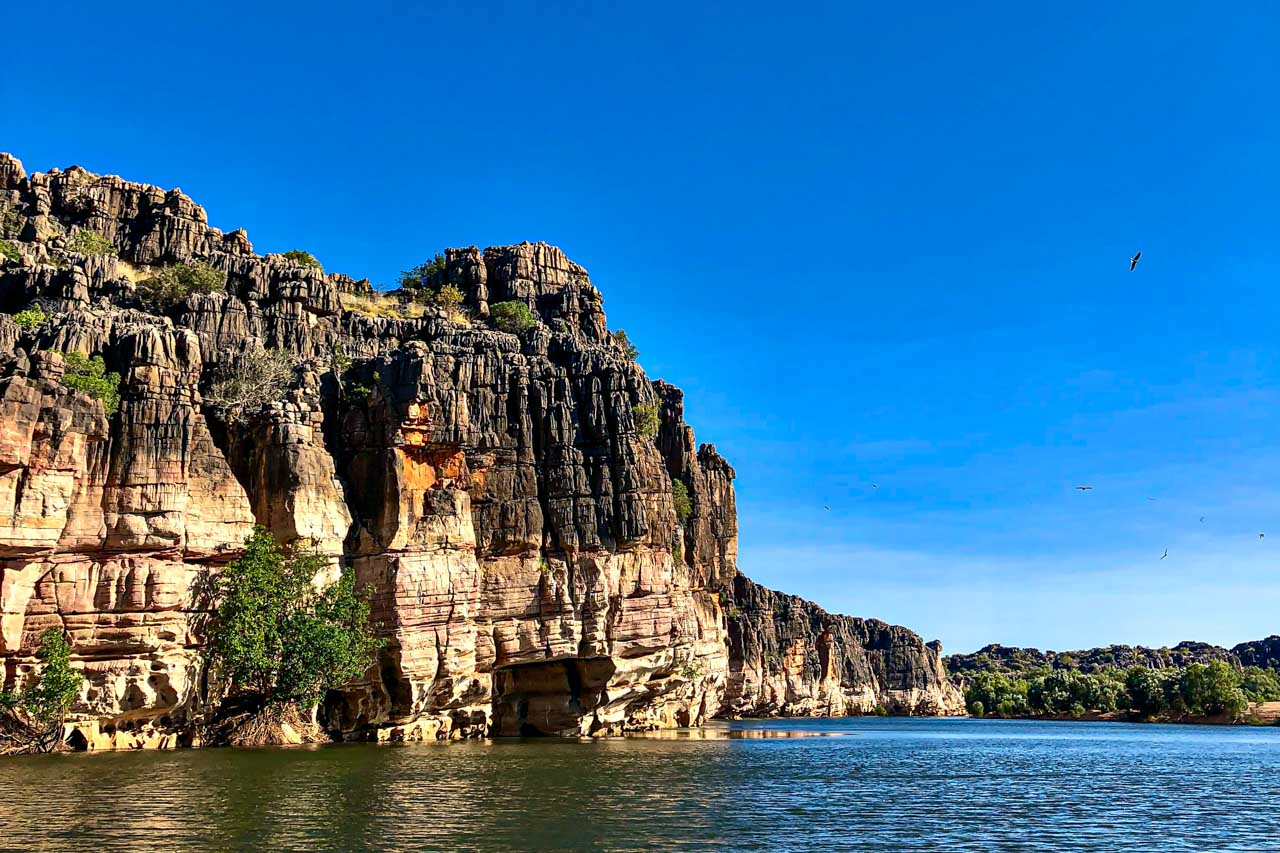
Windjana Gorge (Bandilngan)
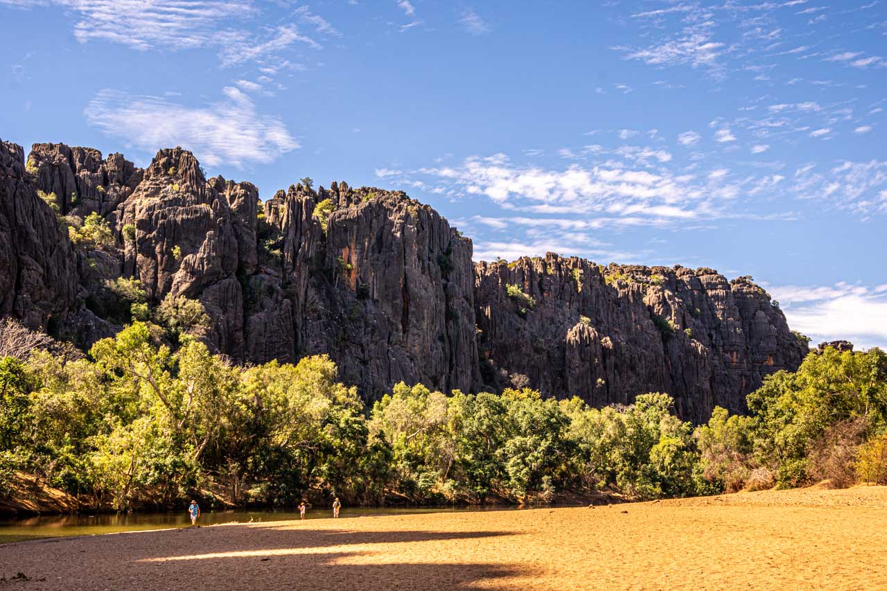
Windjana Gorge
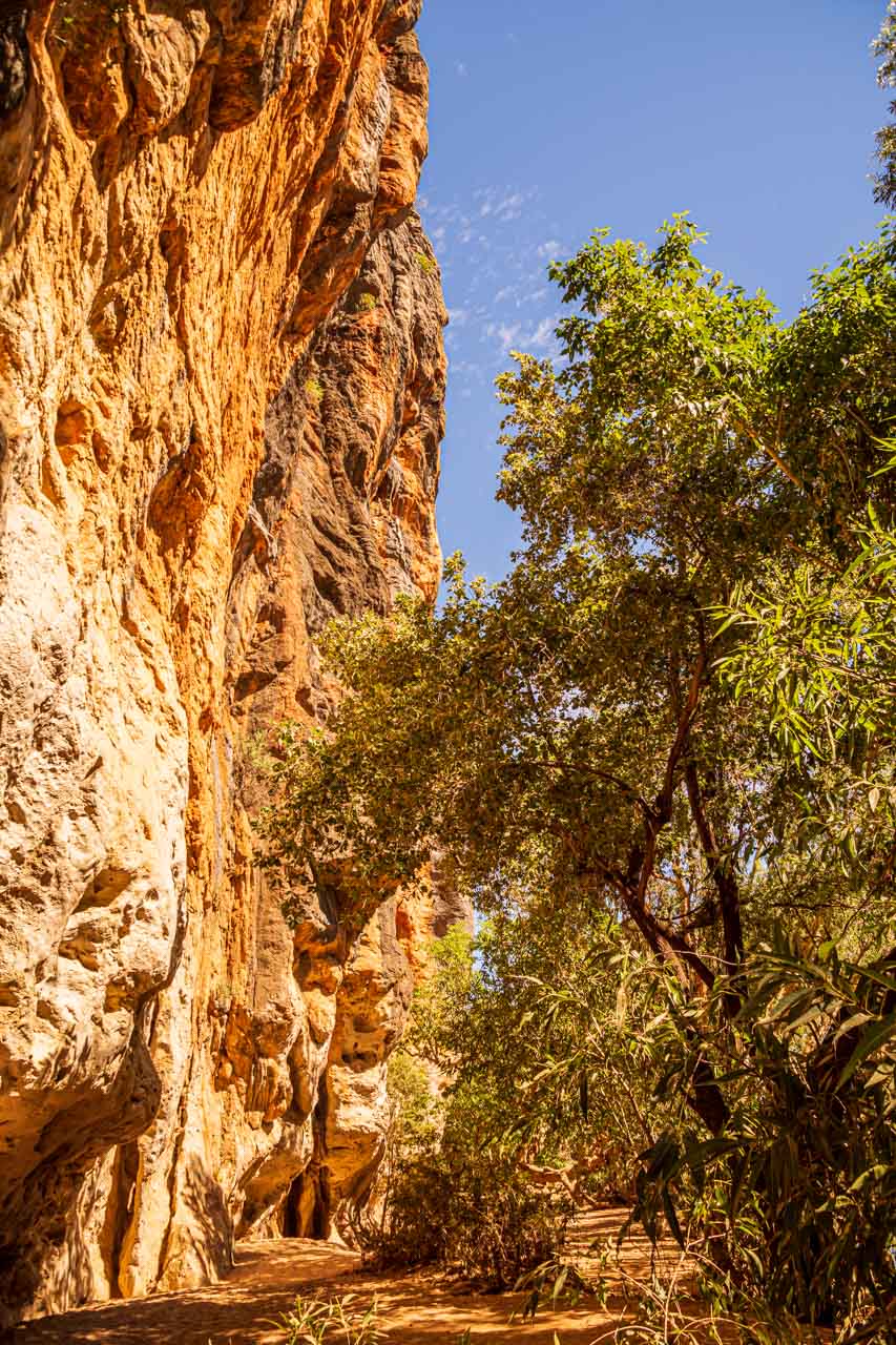
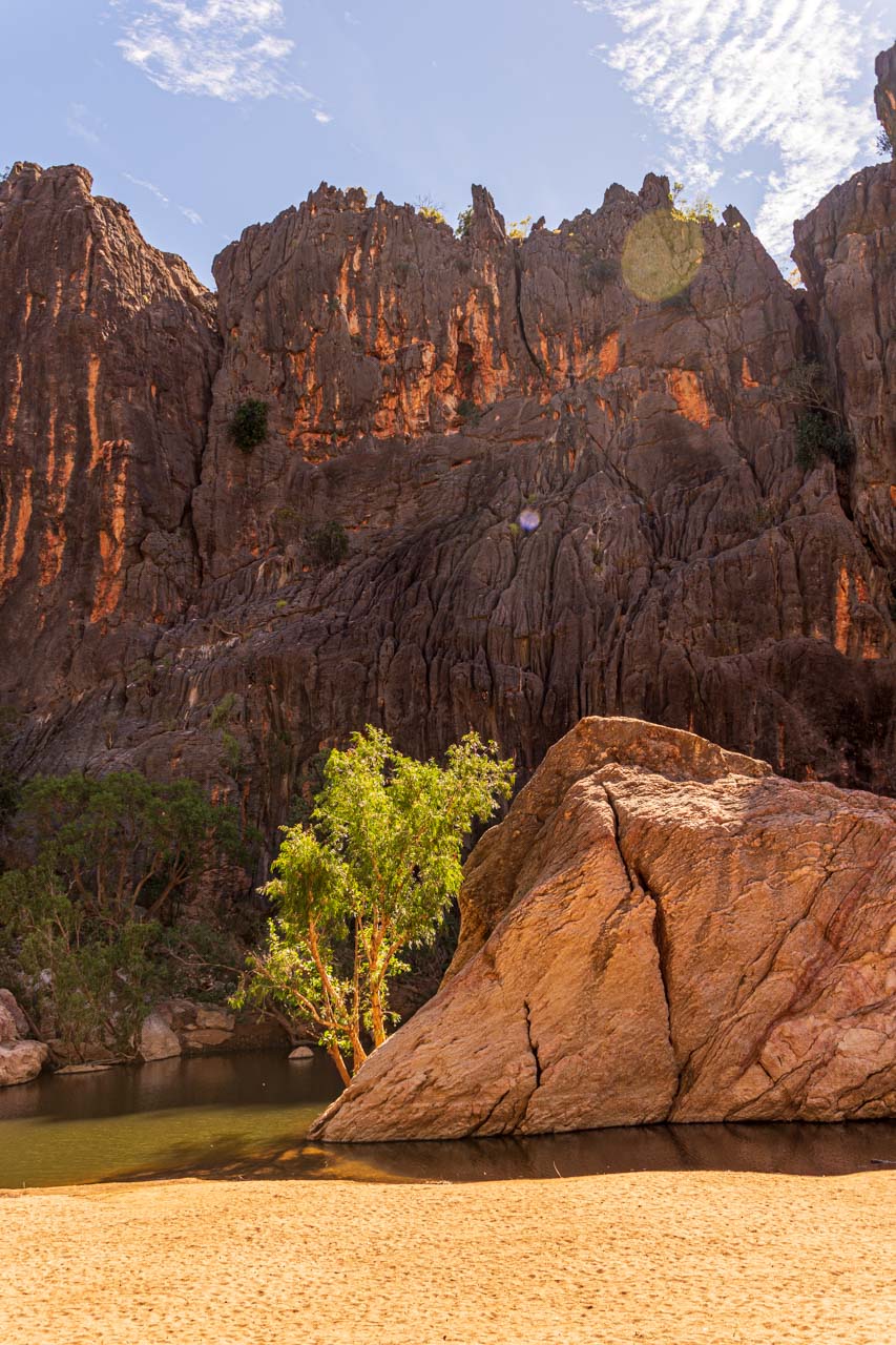
Windjana Gorge is known by its indigenous name, Bandilngan. Located in Bunuba country, in Bandilngan (Windjana Gorge) National Park, the 3.5-kilometre gorge cuts through the Napier Range.
Bangilngan is a stunningly beautiful gorge. Dominating the scene is the Lennard River running through the gorge and majestic water-streaked cliff walls that tower 100 metres above you.
Bangilngan was once part of an inland sea. As you walk along the flat, sandy path through the gorge, it is possible to spot marine fossils. I only saw a couple of fossils, just above head height in the cliff walls, on the gorge walk, but I must admit, I was more interested in the gorgeous scenery that was unfolding around me.
The Kimberley is croc country. Johnston’s (freshwater) crocodiles (known as freshies) inhabit this unspoiled wilderness. I saw many sunning themselves on the sandy riverbank and floating in the water. Unlike their much larger saltwater cousins, freshies are not considered dangerous to humans. However, they can become aggressive and cause injury if disturbed. It is safest not to approach or swim near freshwater crocodiles.
Your best resource for essential information about Bandilngan (Windjana Gorge), including sites and activities, downloads and resources, park passes and fees, camping, safety, and alerts, is Western Australia’s Parks and Wildlife Service.
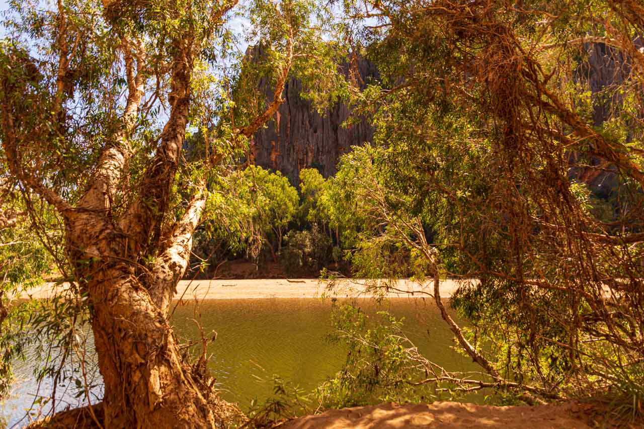
Lennard River flows through Windjana Gorge
Getting there
Bandilngan (Windjana Gorge) is located on the Fairfield-Leopold Downs Road, off Gibb River Road. It is 146 kilometres northwest of Fitzroy Crossing and 144 kilometres east of Derby.
The only access is by unsealed roads. A four-wheel-drive (4WD) vehicle is recommended to access the park. The park is closed during the wet season as the roads are inaccessible.
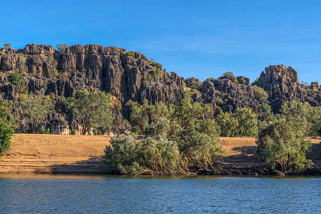
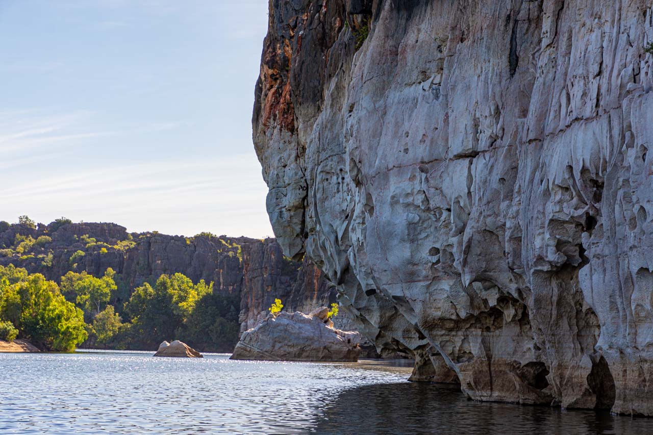
Danggu Geikie Gorge
Geikie Gorge has been carved by the Fitzroy River
Geikie Gorge is known as Darngku by the Bunuba traditional owners. Located in Danggu Geikie Gorge National Park in the Wunaamin Miliwundi Ranges (formerly King Leopold Ranges), the 30-metre-deep gorge has been carved by the Fitzroy River. The park’s entrance is on Leopold Downs Road.
Danggu Geikie Gorge is a spectacular gorge famed for its sheer white and grey cliff walls. The bleaching of the walls is thanks to the Fitzroy River’s massive flooding during the wet season.
The Fitzroy River is the second largest in the world – second only to the Amazon River. The park ranger clarified “largest” as that being the volume of water flowing through the gorge.
During the wet season, the river rises between 10–16 metres, polishing the walls of the gorge white and the flooding sections of the park with up to seven metres of water. The dry season sees the river transformed into a peaceful stream beneath the towering limestone cliffs. Honeycomb weathering is a fascinating feature of gorge walls.
There are several riverside walks in Danggu Geikie Gorge National Park. However, instead of walking through the gorge, we took a one-hour cruise on the Fitzroy River with the Department of Parks and Wildlife Service operated boat tour. One of the park rangers was our guide on the boat tour. I recommend taking the boat tour because it gives a unique perspective of the park, and the ranger’s commentary on the wildlife and geology of the gorge is insightful.
Visit Western Australia’s Department of Parks and Wildlife Service for all your essential information on Danggu Geikie Gorge.
Getting there
Danggu Geikie Gorge National Park is the most accessible national park in the Kimberley.
Travelling the Great Northern Highway, the park is 417 kilometres from Broome, 278 kilometres from Derby, and only 20 kilometres from Fitzroy Crossing. A four-wheel-drive vehicle is not required.
From Fitzroy Crossing, take Russ Road for 3-4 kilometres before turning left onto Geikie Gorge Road. The park’s entrance is at the end of Geikie Gorge Road.
Danggu Geikie Gorge National Park is a day-use park only, open from 6.30 am to 6.30 pm but closed during the wet season. No entry fees apply.
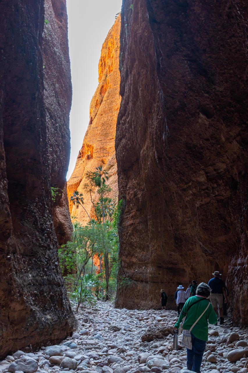
Cathedral Gorge
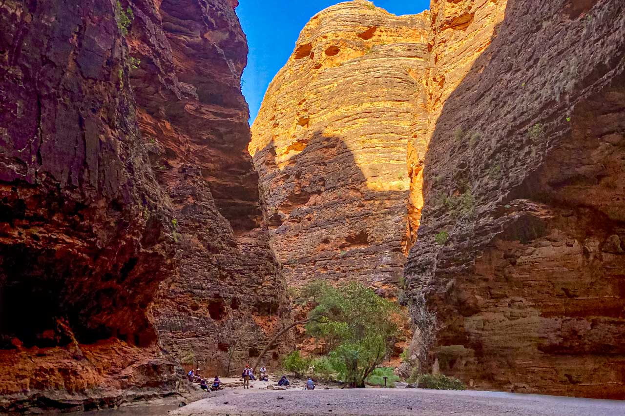
Cathedral Gorge in the Bungle Bungles
Cathedral Gorge is in the Bungle Bungle Range (also called the Bungle Bungles), in the UNESCO World Heritage-listed Purnululu National Park.
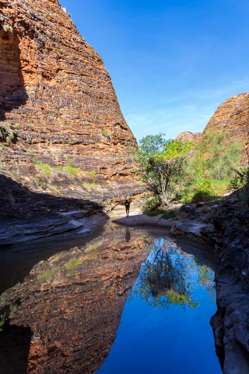
Cathedral Gorge is an enormous, circular cavern, forming a natural amphitheatre of red rock renowned for its acoustics. I have seen photos of orchestras playing in the cavern. While no one was singing to test the acoustics, I could hear conversations from around the cavern.
The waterfall that flows from the cavern roof can only be seen in the wet season when Purnululu National Park is closed. The day I visited, early in the dry season, there was no waterfall. But there remained a large pool of water in the centre of the cavern.
The walk into Cathedral Gorge is a two-kilometre return trail from Piccaninny Creek car park. The trail takes you past the orange and black striped domes, of which Purnululu National Park is most famous for. It is these characteristic striped formations that give the Bungle Bungles their nickname of ‘beehives’.
Classified as a moderate walk, the trail is rocky in parts, and there are metal ladders to help you up and down some tricky rocky sections.
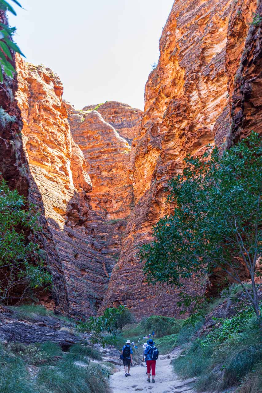
The Bungle Bungle Range has been around for 350 million years but was only ‘discovered’ in 1983 when a documentary team spotted it from the air and brought it to world attention.
I recommend a helicopter flight over the Bungle Bungles to get spectacular views and an accurate idea of their scale.
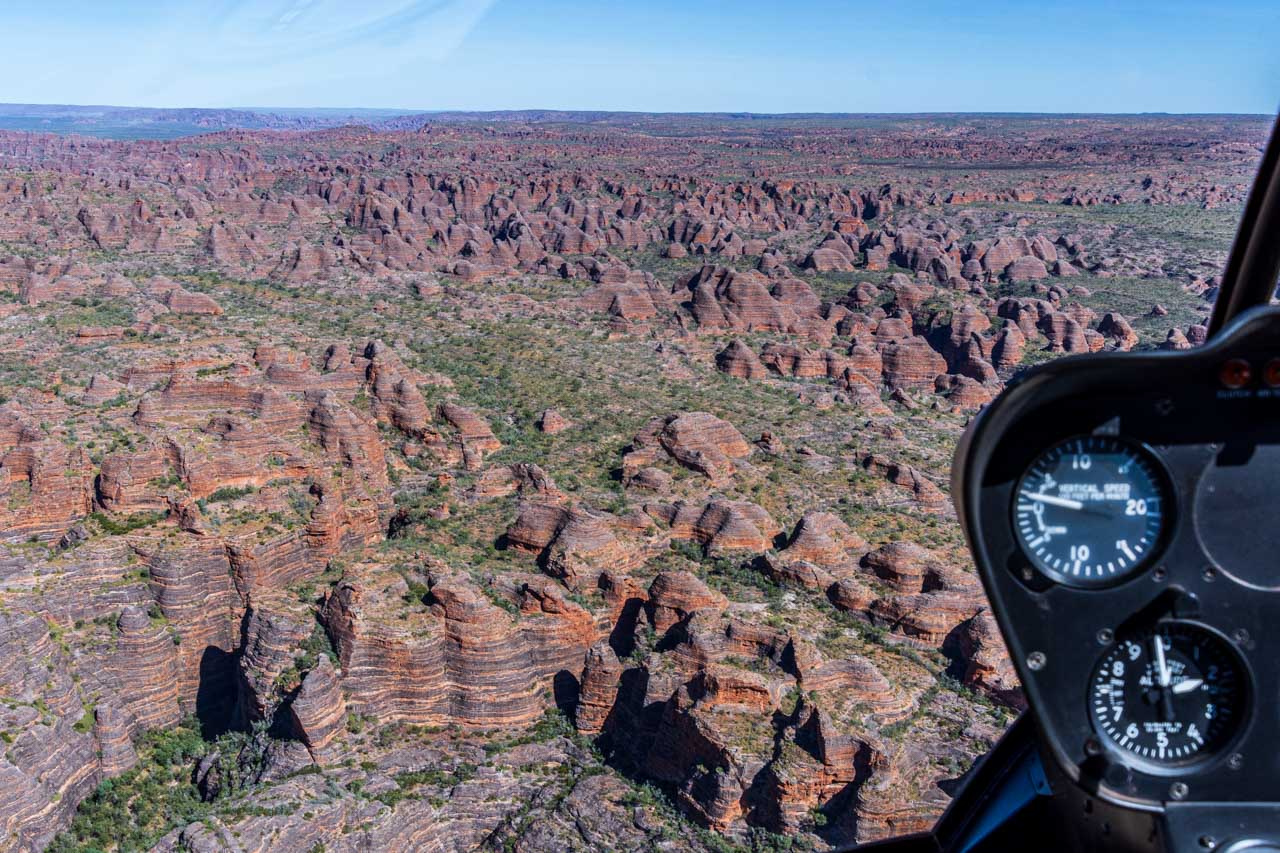
The Bungle Bungle Ranges viewed from a helicopter
Getting there
Purnululu National Park is remote. It is in the East Kimberley, about 100 kilometres north of Halls Creek and 250 kilometres south of Kununurra.
Access to the park is via Spring Creek Track, from the Great Northern Highway approximately 250 km south of Kununurra, to the track’s end at the Purnululu National Park Visitor Centre. The track is 53 km long and is usable only in the dry season and only by 4WD high clearance vehicles and off-road trailers. Safely navigating it takes approximately three hours. From the Purnululu National Park Visitor Centre, the trail is located a further 27 kilometres drive south.
It is advisable to check with the Department of Parks and Wildlife’s Kununurra office on 08 9168 4200 for the current weather forecast and road conditions before entering the park.
There is an entry fee to Purnululu National Park. Visitors must register at the Visitor Centre on arrival at the park.
For more information and alerts, visit Parks and Wildlife Service.
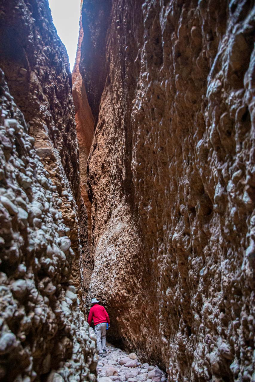
Echidna Chasm
Echidna Chasm
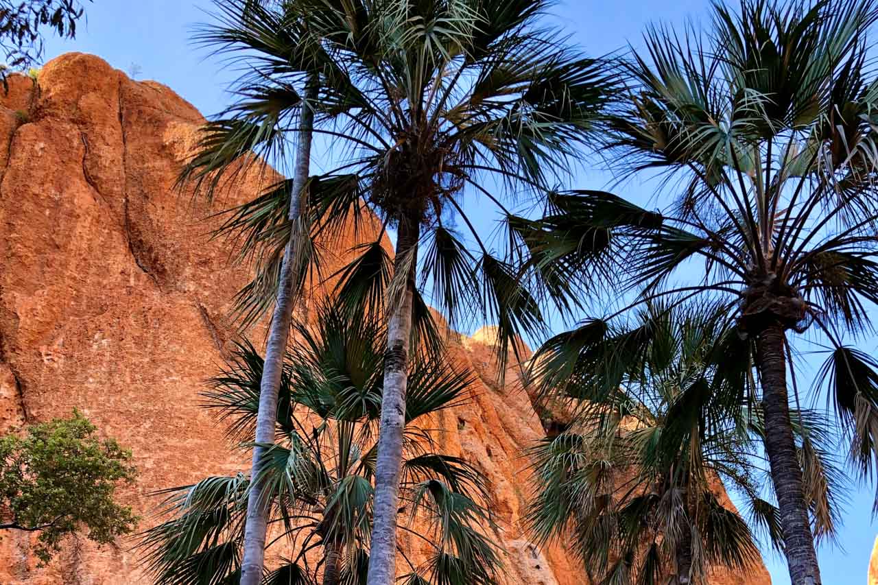
At the northern end of Purnululu National Park is the spectacular, 180-metre-deep Echidna Chasm.
The chasm’s soring 200-metre-high red walls seem to glow where the sun shines on them. The liberal scattering of Livistonia palms found in the early section of the Echidna Chasm Walk are breathtaking and seem out of place. ‘Breathtaking’ takes on a whole different meaning as the walls of this crack in the rock, which is Echidna Chasm, become progressively narrower to barely a metre wide in places.
The two-kilometre return walk into the chasm begins at Echidna Chasm car park. The path into the chasm follows a very uneven, stony, dry creek bed. To make it to the end of the chasm requires scrambling over large fallen boulders and scaling ladders. The last 100 metres is the most challenging.
Getting there
The turn-off to Purnululu National Park is on the Great Northern Highway, approximately 250 kilometres southwest of Kununurra and 100 kilometres northeast of Halls Creek. From the turn-off, access to the park is via Spring Creek Track. This is a rugged track that is suitable for 4WD vehicles and single-axle off-road trailers only. Two-wheel-drive (2WD) vehicles may be refused entry. Caravans may be stored at the caravan park located at the turn-off (fees apply).
Spring Creek Track is a narrow, unsealed track with several creek crossings, some sharp corners, and ascents and descents. Allow approximately 2.5-3 hours for this 53-kilometre journey.
Echidna Chasm is 19 kilometres from Purnululu National Park Visitor Centre.
Entry and camping fees apply for Purnululu National Park. Visitors must register at the Visitor Centre on arrival at the park.
Purnululu National Park is closed during the wet season.
For more information and alerts, visit Parks and Wildlife Service.
Manning Gorge
Manning Creek in Manning Gorge
Manning Gorge is on Mount Barnett Station in the Wunaamin Miliwundi Ranges (formerly King Leopold Ranges).
The 5.6-kilometre return gorge walk starts at the Manning Gorge campground on Manning Creek, where you first must cross the creek to re-join the trail on the other side. You need to swim the 100 metres across Manning Creek, but there are available blue plastic drums cut in half to float your possession across the creek, keeping them dry as you swim. There is a rickety ladder, sort of secured to the riverbank, to help lower yourself into the creek.
The Manning Gorge walking trail follows an overland route rather than along the creek. It is a challenging walk over uneven, rocky terrain with some rock scrambling and climbing that gets progressively harder near the end. However, your reward at the end is a massive gorge with a huge waterfall-fed pool and smaller pools suitable for swimming.
Manning Gorge offers some of the most picturesque and safe swimming holes in the Kimberley. Even if you don’t walk to the gorge itself, a swim in Manning Creek with its tree-lined sandy riverbank is a delightful way to while away a few hours. Take a picnic lunch with you.
The waterfall and pools in Manning Gorge (Depositphotos_210779876)
Getting there
Manning Gorge is approximately 315 kilometres northeast of Derby via the Derby-Gibb River Road and 398 kilometres southwest of Kununurra via the Gibb River-Wyndham Road.
Manning Gorge is accessible only by 4WD. Be warned, Gibb River Road is a seriously corrugated dirt road with several river crossings.
An entrance permit is required to access Manning Gorge, purchased at the Mount Barnett Roadhouse (one of the most remote roadhouses in Australia) – about seven kilometres from Manning Gorge campground.
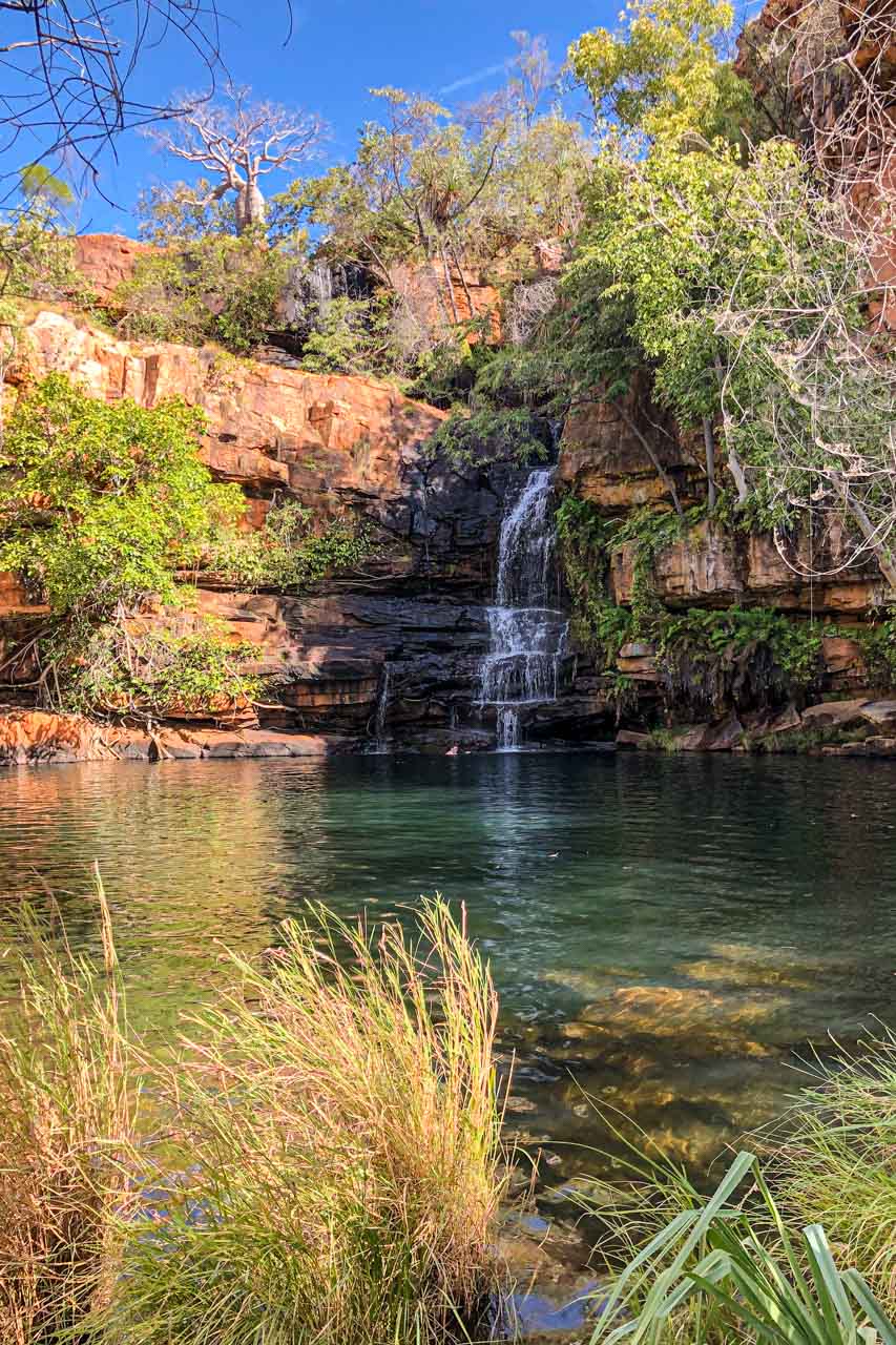
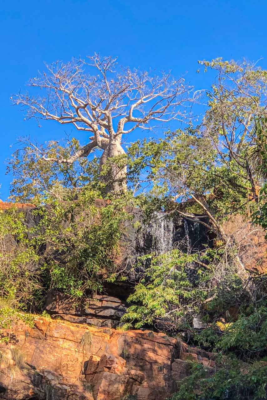
Galvans Gorge

Galvans Gorge
Galvans Gorge is the most accessible gorge along Gibb River Road. It is located on Mount Barnett Station, one kilometre off Gibb River Road in the Phillips Range.
Galvans Gorge is a pretty, little gorge that has it all:
- A multi-tiered waterfall plunging down the rocky gorge.
- A horseshoe-shaped natural pool at the bottom of the waterfall, ideal for a refreshing swim.
- An abundance of lush vegetation framing the pool and providing shade for most of the day.
- An iconic Boab tree standing guard at the top of the falls.
- Ancient Windjana rock art on the gorge wall.
Galvans Gorge is a delightful spot to relax.
The walk into Galvans Gorge from the roadside car park is an easy, mostly flat, one kilometre (one way) track with rocky surfaces in several sections.
Getting there
Galvans Gorge is located 14 kilometres from Mt Barnett Roadhouse, approximately 290 kilometres west of Derby on Gibb River Road.
Gibb River Road is only accessible during the dry season.
Entry to Galvans Gorge is free
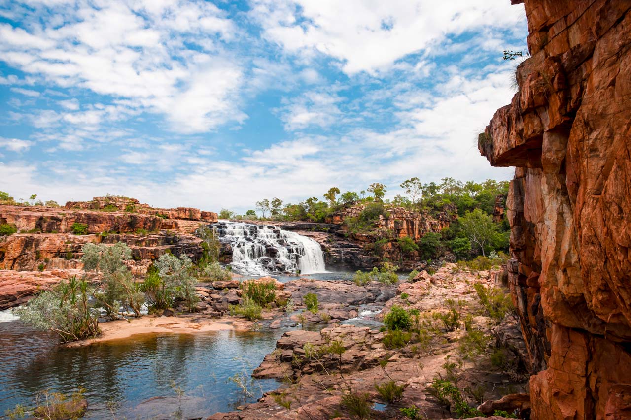
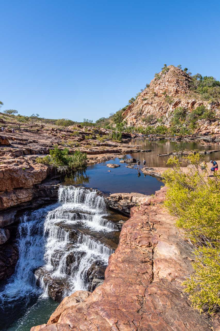
Bell Gorge
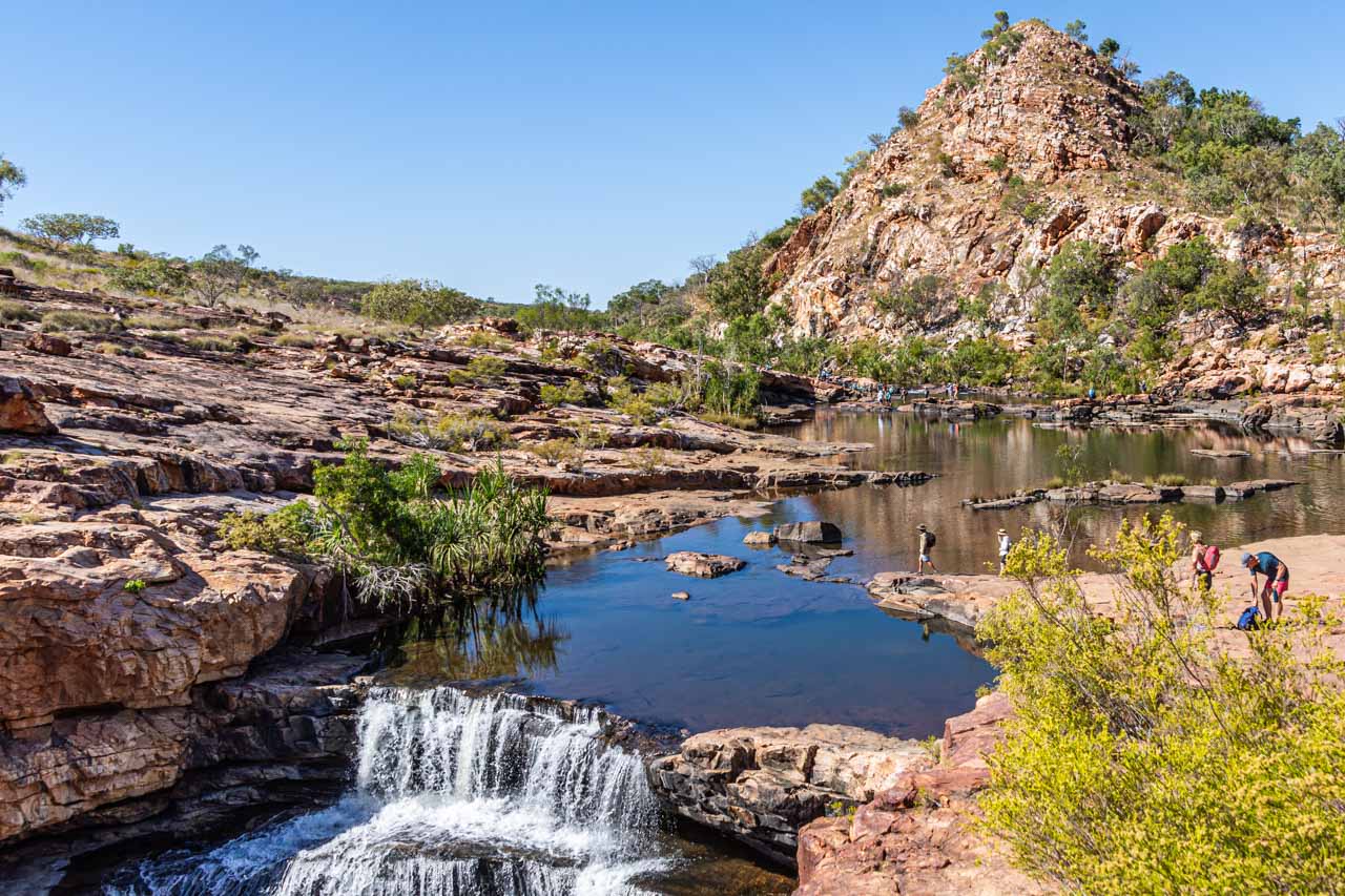
Bell Gorge at the top of the waterfall
Beautiful Bell Gorge, with its stunning landscape, is a photographer’s delight. If asked which was my favourite gorge on my Kimberley adventure, without hesitation, my response would be Bell Gorge.
Bell Gorge is in King Leopold Ranges Conservation Park (now referred to by its Aboriginal name, Wunaamin Miliwundi Ranges Conservation Park). It is described as one of the most picturesque and scenic gorges in the Kimberley, where Bell Creek drops 150 metres into a gorge to form a wide, U-shaped, stepped waterfall cascading into a deep pool. Bell Gorge is a wonderful swimming spot.
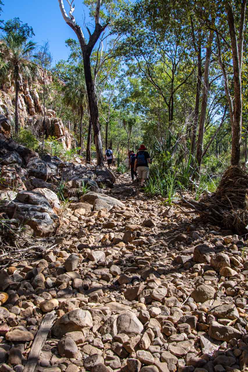
From the car park, it is a one-kilometre walk along a challenging rocky dry creek bed to reach the gorge. I say ‘challenging’ for two reasons:
- there is a moderate incline at the beginning of the track, which had me puffing when walking back up on my return; and
- the rocks you are walking on are all loose, making it necessary to concentrate on your balance.
However, at the end of the track, the gorge opens up to an impressive vista and rock pools at the top of the waterfall. One of the rock pools is a natural infinity pool, allowing you to swim right up to the edge of the waterfall.
Then, there is the swimming option of the deep pool below the waterfall. According to my travel companions who walked to the bottom swimming pool, the one-kilometre return trek is manageable but will test your hiking skills. First, you need to cross Bell Creek to the opposite side. As the rocks where you cross can be slippery, our guide recommended wearing socks (no shoes) to cross the creek. Apparently, this worked a treat. Once across the creek, you climb down a steep, rocky track (which you must climb back up again) to access the bottom swimming pool and swim below the waterfall within the gorge. My fellow travel companions told me the swim was delightful and well worth the challenging hike.
Don’t forget your sunscreen and take plenty of water.
Getting there
Bell Gorge is about 247 kilometres east of Derby along Gibb River Road. Turning off the Gibb River Road, Bell Gorge car park is approximately 30 kilometres along Silent Grove Road, a corrugated road requiring a 4WD.
Bell Gorge is in a national park, so entry fees apply, paid at Silent Grove campground. It is inaccessible during the wet season. Before travelling to Bell Gorge, it is advisable to check for alerts and closures.
When to go
The Kimberley has no summer or winter, just wet or dry due to its tropical monsoon climate. The wet season is November to April, and the dry season is May to October.
I travelled to the Kimberley in June, early in the region’s dry season. The daily temperatures ranged from the high 20s to low 30s degrees Celsius. The nights were cooler, and the only rain I experienced was one night when back in Broome at the end of the escorted tour.
If you want to avoid oppressive heat and humidity, cyclones, and flooded rivers, then travel to the Kimberley in the dry season. Much of the Kimberley is impassable during the wet season. Flooded rivers isolate towns, accommodation, and inhabitants during the wet season.
The national parks in the Kimberley are only accessible during the dry season.
Road conditions in the Kimberley can vary greatly and change rapidly. Refer to Parks and Wildlife Service for all your essential information on the Kimberley’s national parks.
Getting there and around
The Kimberley is remote. Even so, you have several options for getting to the Kimberley. I took a direct flight from Sydney to Broome (the ‘capital’ of the Kimberley) but, alternatively, you could drive, hop on a bus, or take a guided tour.
After a week on my own in Broome, I joined APT’s 15-day escorted 4WD adventure tour around the Kimberley. Our ‘4WD’ was a bus on steroids – the body of a bus on a truck chassis. It was on this tour that I was able to experience the beautiful gorges described above.
A 4WD is necessary for travelling around much of the Kimberley if you leave the tarred highway. You should also consider travelling with a satellite phone as there were several areas where there was no mobile phone coverage. At times, I did not even have SOS access on my phone.
The pleasures of travelling on an escorted tour were not having to worry about visitor passes or wondering how I would get from A to B or concerned about damaging my car (if I owned a 4WD) on severely corrugated dirt roads.
Disclaimer: This post contains no affiliate links. All views and opinions are my own and non-sponsored. Unless expressly stated, all photos are my own and remain the copyright © of Just Me Travel 2021.
Have you been to the Kimberley in Western Australia? Which gorges have you explored in the Kimberley that you would like to share with readers? Leave a comment below to share your thoughts on this blog post.
Like this post? PIN it!
Related Kimberley posts
-> How to See Horizontal Falls and Epic Tides, Australia
-> The Ultimate Guide to 6 Safe Swimming Holes in the Kimberley, Australia
-> 15 Photos to Inspire You to Visit Broome, Western Australia
Are you looking for more ideas for destination Western Australia? Then don’t miss these posts:
23 GREAT PHOTO SPOTS ON THE ROAD FROM PERTH TO BROOME, AUSTRALIA
7 TOP DAY TRIPS AND THINGS TO DO IN AND FROM PERTH, AUSTRALIA
Author’s Note: Please check the latest travel restrictions before planning any trip, and always follow government advice.
No Comments on SEE 7 BEAUTIFUL GORGES IN THE KIMBERLEY – the ultimate guide