DEAR MEG, Down a laneway in Ballarat is a hidden gem that inspires a true sense of community at its best. Pip had recently seen a feature story on…
Food Is Free Laneway, Ballarat
DEAR MEG,
Down a laneway in Ballarat is a hidden gem that inspires a true sense of community at its best.
Pip had recently seen a feature story on the ABC’s Gardening Australia about Ballarat’s Food is Free project. So, when arriving in Ballarat on our Victorian road trip, we were keen to check out the Food Is Free Laneway.
It was not the best day for a walk as it was bitterly cold, with the wind-chill factor making it difficult to walk because we were freezing. But we persevered and eventually found the Food Is Free Laneway.
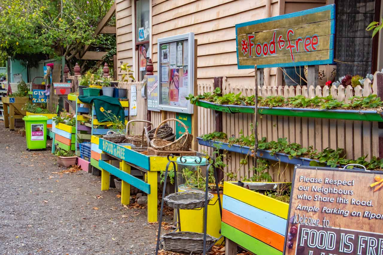
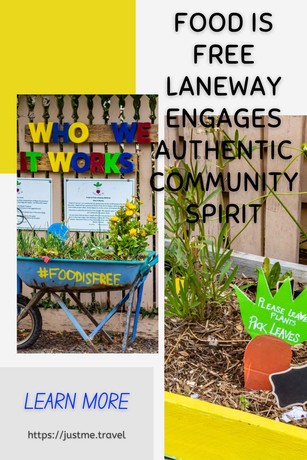
We already knew from the Gardening Australia story that Ballarat resident Lou Ridsdale founded the Ballarat Food Is Free Laneway in October 2014. The laneway is adjacent to her home – at 305 Ripon Street South, near the corner of Ripon Street South and Warrior Place.
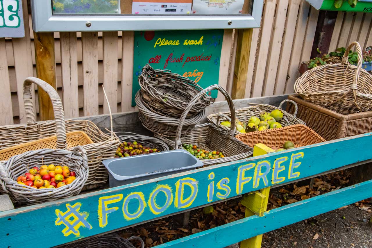
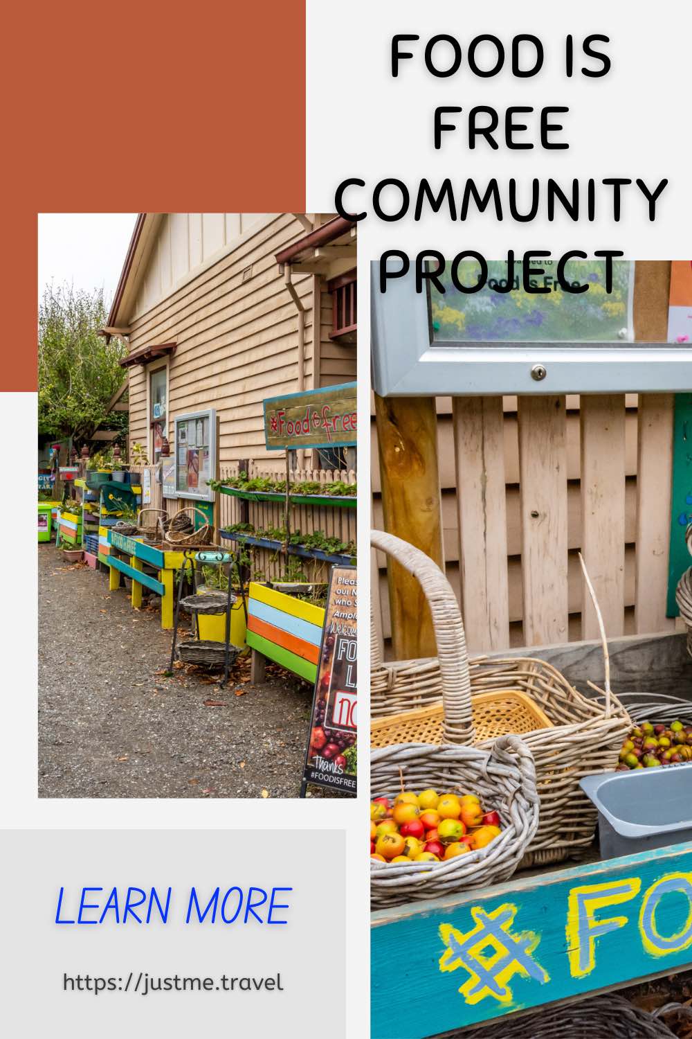
We also had foreknowledge about the purpose of the Food Is Free Laneway; that it is, as the name implies, about sharing food for free. People drop off their excess produce, which is accessible to everyone at no cost (except perhaps a chat with a neighbour). This sharing has gone a long way to building community interconnections and engagement.
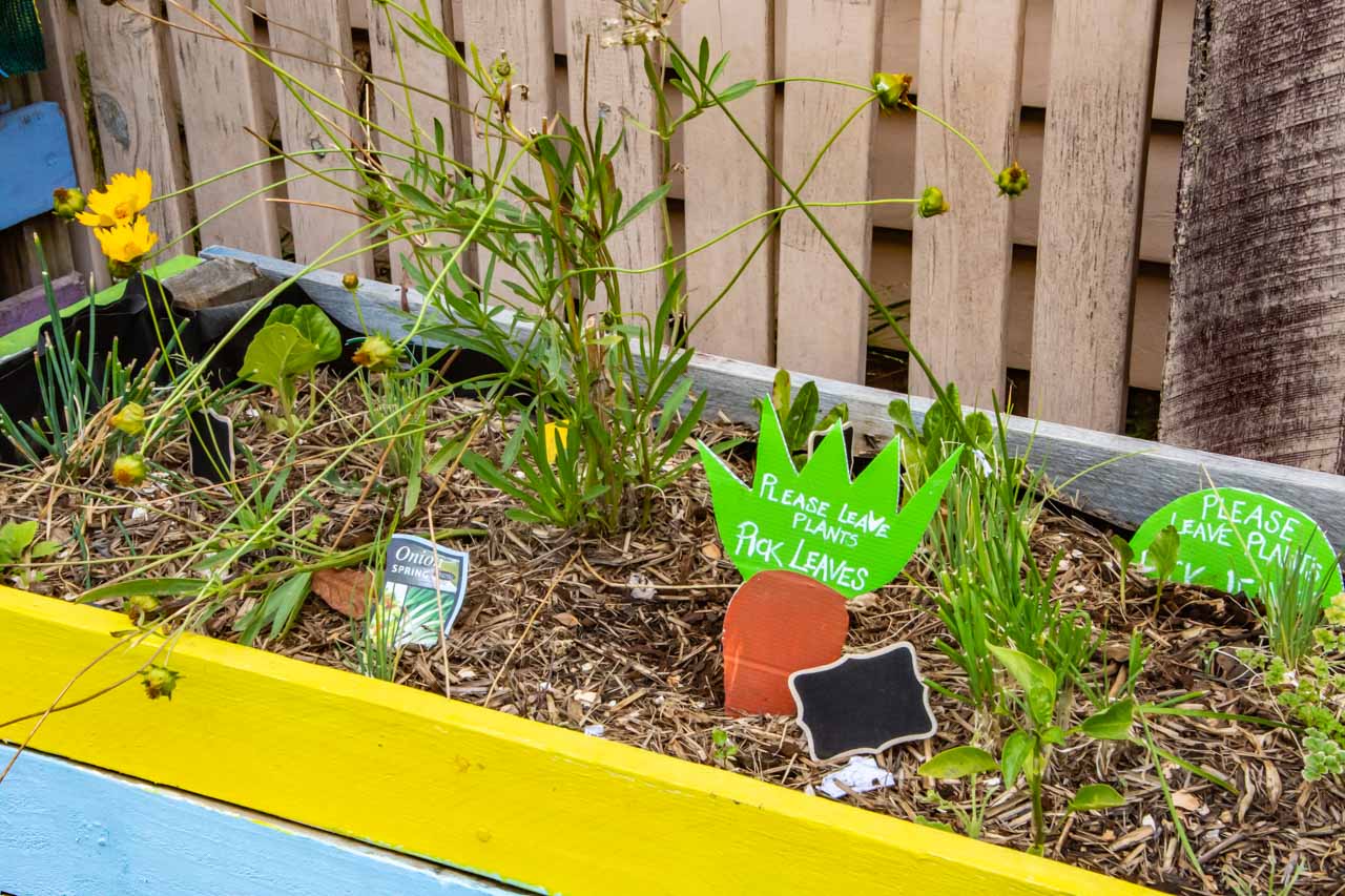
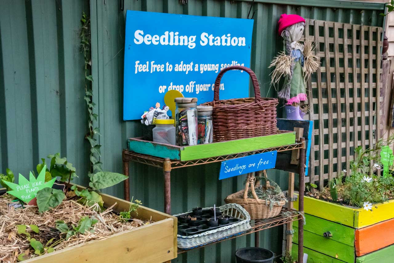
Boxes and tables of fresh fruits, vegetables, and herbs, donated by the public for people to take as they want, extended the length of the laneway. There were also drawers of seeds and excess pots and jars for the taking.
We didn’t meet Lou but chatted to the volunteer who was manning the laneway and keeping things in order. She told us that a team of volunteers help out at the site. This is important as people will want to drop off, for example eggs, but only fresh veggies, fruits, and herbs can be accepted.
The Food Is Free Laneway is a unique project for sustainably managing excess food, assisting those less advantaged, and building community through collaboration. It is a credit to Lou and the volunteers, who donate their time to this community initiative. It is also a credit to the Ballarat community who have embraced Food Is Free.
As we were leaving, a lady arrived to drop off some vegetables. We were off to find hot soup.
Cheers,
Joanna
Baskets of fresh fruits and veggies – Food Is Free Laneway, Ballarat
Fresh herbs – Food Is Free Laneway, Ballarat
Seedlings and herbs – Food Is Free Laneway, Ballarat
Editor’s Note: This blog post was originally published in July 2019 and has been updated for accuracy and comprehensiveness.
Disclaimer: This post contains no affiliate links. All views and opinions are my own and non-sponsored. All photos are my own and remain the copyright of Just Me Travel.
Please leave a comment below to share your thoughts. What community projects have you witnessed or participated in?
Experience One of Australia’s Most Iconic Road Trips Driving Victoria’s Great Ocean Road. The Great Ocean Road is Australia’s most famous coastal drive and one of the best road…
Experience One of Australia’s Most Iconic Road Trips Driving Victoria’s Great Ocean Road.
The Great Ocean Road is Australia’s most famous coastal drive and one of the best road trips in the world. Famed for its stunning scenery, what better way to show you the natural phenomena, incredible wild views, and beauty of the Great Ocean Road than through the photographs I took on a photo tour road trip. Enjoy!
Victoria’s Great Ocean Road was placed on the Australian National Heritage list in April 2011 as a place of outstanding national heritage significance. The 242-kilometre Great Ocean Road follows the stunning coastline of Victoria’s southwest from Torquay to Allansford. The road winds along clifftops beside breathtaking headlands, down onto the edge of beaches, across river estuaries and through rainforests, offering ever-changing diverse landscapes and views of Bass Strait and the Southern Ocean.
The Great Ocean Road was built by returned soldiers between 1919 and 1932 and dedicated to soldiers killed during World War l. The road is the world’s largest war memorial.
To take a road trip along the Great Ocean Road is a drive I have wanted to do for many years, but something always got in the way. So, when I came across the Great Ocean Road Photo Tour with Mark Gray Photography, I could think of no better way to combine my desire to drive the Great Ocean Road and my passion for travel photography.
As a keen amateur photographer, I often seek out photography tours around the world. I firmly believe I can never stop learning and what better way to learn and master landscape photography than out of the classroom with a professional photographer by your side guiding you along the way.
Mark Gray Photography’s tours are suitable for amateur to semi-professional photographers and are limited to 6-8 participants, ensuring everyone gets plenty of individual tuition at each location from the accompanying professional and experienced photographer. The Great Ocean Road Photo Tour locations, accommodation, and meals were well researched by Mark Gray Photography, with appropriate scheduling across the five days.
Great Ocean Road Photo Tour route
Great Ocean Road photo tour route from Melbourne return (Google Maps)
The pickup point for our Great Ocean Road Photo Tour was in Melbourne outside St Paul’s Cathedral, near Flinders Street Railway Station.
Our route over the five days took us along the Great Ocean Road through the Victorian towns of Geelong, Torquay (the start of the Great Ocean Road), Anglesea, Lorne, Apollo Bay, Port Campbell, Allansford (the end of the Great Ocean Road), Warnambool, and on to Port Fairy (our final stop). The return trip to Melbourne from Port Fair on day five, after a sunrise shoot, breakfast, and photo critiquing session, was via Colac, where we stopped for lunch.
The photos below are shown in the order in which they were seen and taken, giving a visual journey along the spectacular Great Ocean Road.
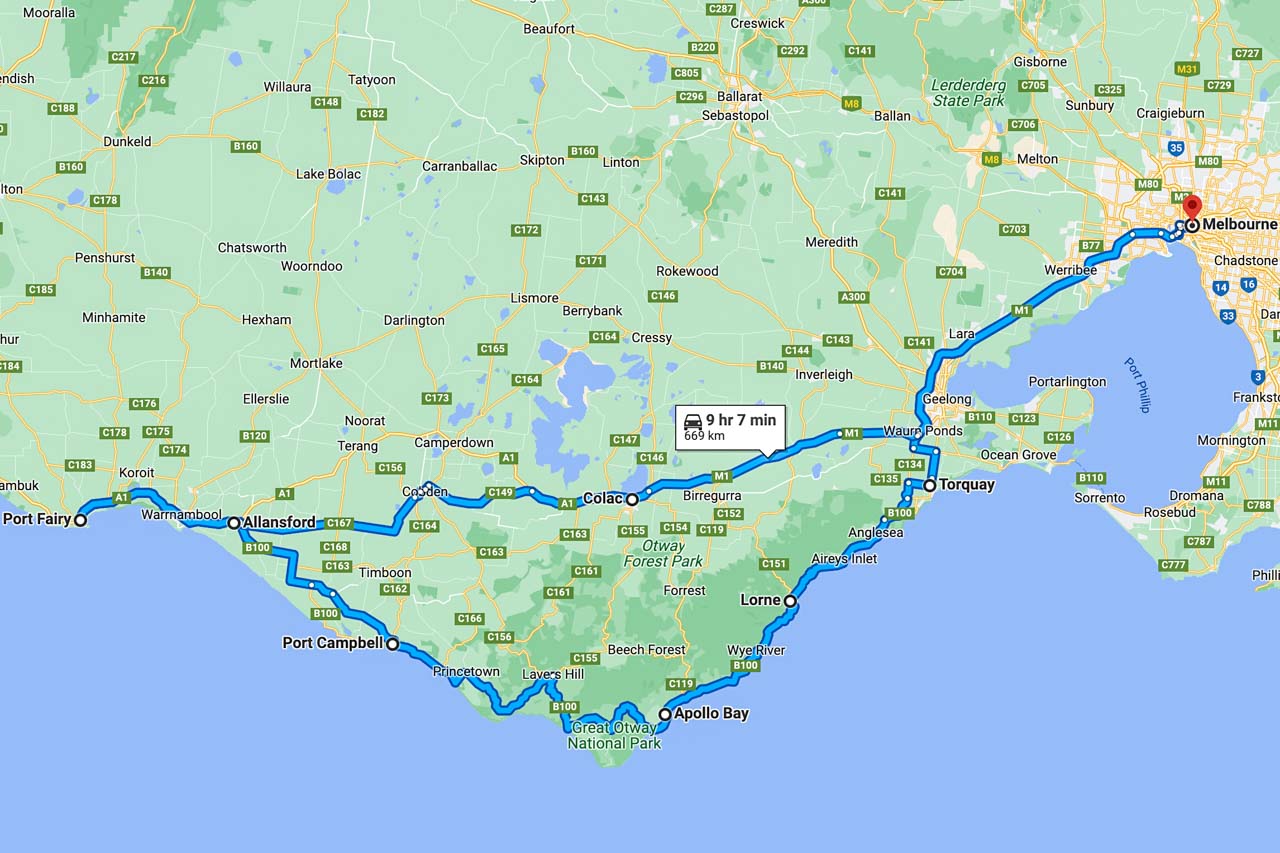
Lower Kalimna Falls, Great Otway National Park
Leaving from Sheoak Picnic Area near Lorne in the Great Otway National Park, the six-kilometre return walking track to Lower Kalimna Falls through the creek valley follows the old trolley way used many years ago for hauling timber to Lorne.
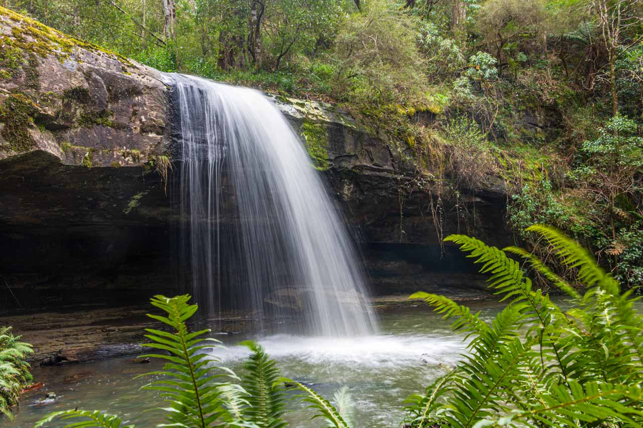
Lorne Suspension Bridge
The Lorne Suspension Bridge is a timber footbridge over the Erskine River near its mouth. An iconic landmark of Lorne, the bridge was completed in 1937.
Redwoods of the Otway Ranges
Beech Forest in the Great Otway National Park is home to a thriving small, sheltered grove of Coastal Redwoods – the world’s tallest tree species. Towering on the river flat at Aire Valley Plantation, these redwoods were planted in 1936 by Victorian foresters for experimental purposes. They were never cut down, and although still in their infancy growth phase, they now stand about 60 metres high. Even though ‘babies’, their height as they reach for the sky still left me in awe of the sight.
It was very peaceful walking through the grove as I listened to the rippling of the water from the river flowing beside the grove of redwoods.
There is a picnic area across the road from the redwoods.
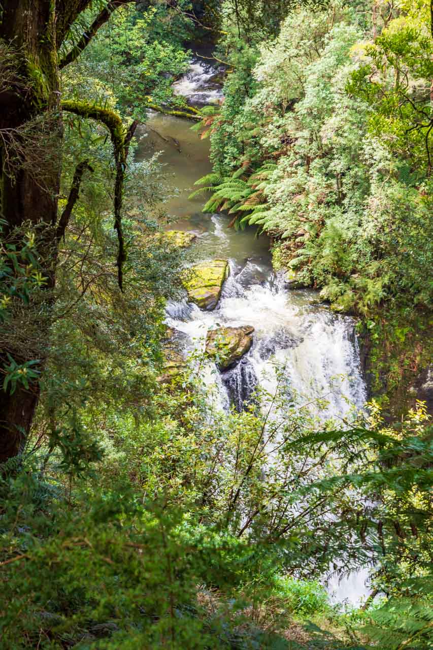
Hopetoun Falls, Great Otway National Park
Deemed by some as the most beautiful waterfall in Victoria, Hopetoun Falls in Beech Forest plummets 30 metres into the Aire River. Take in the view from the upper platform or descend around 200 stairs to the bottom of the falls.
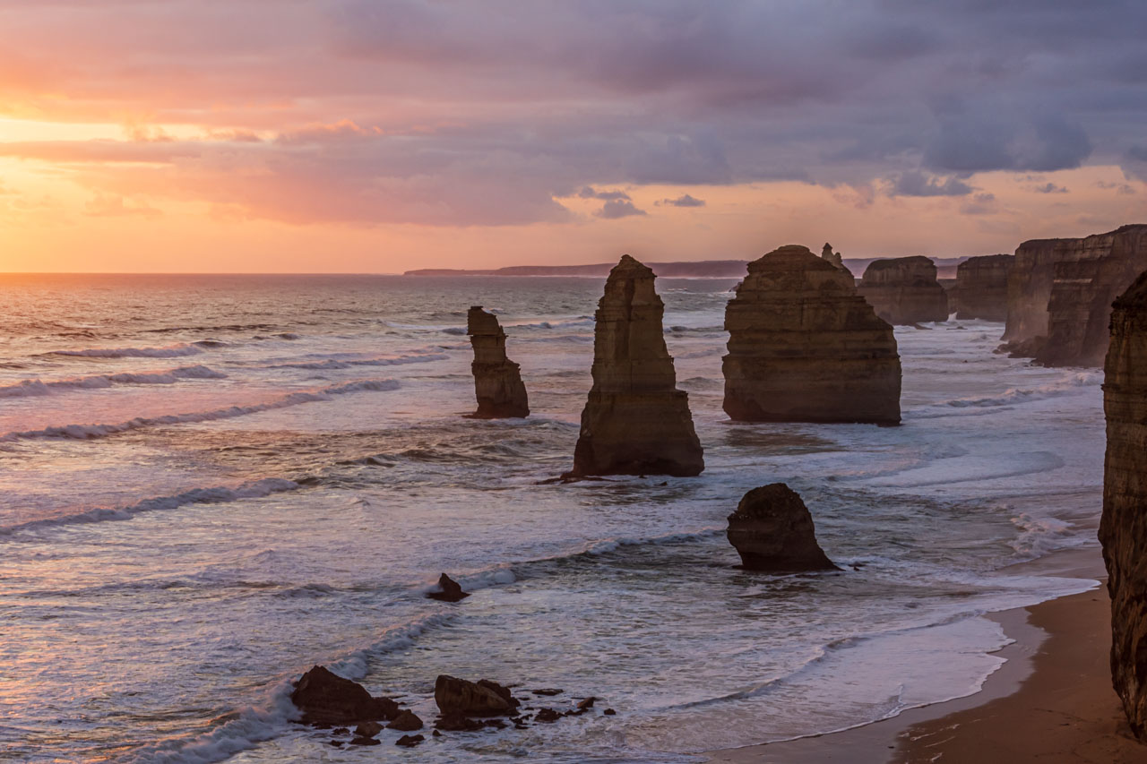
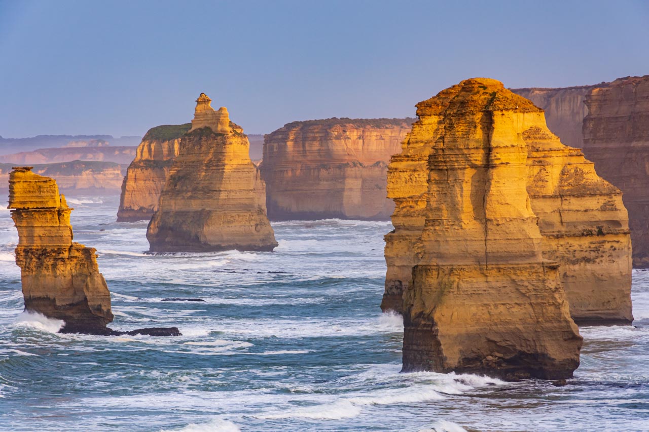
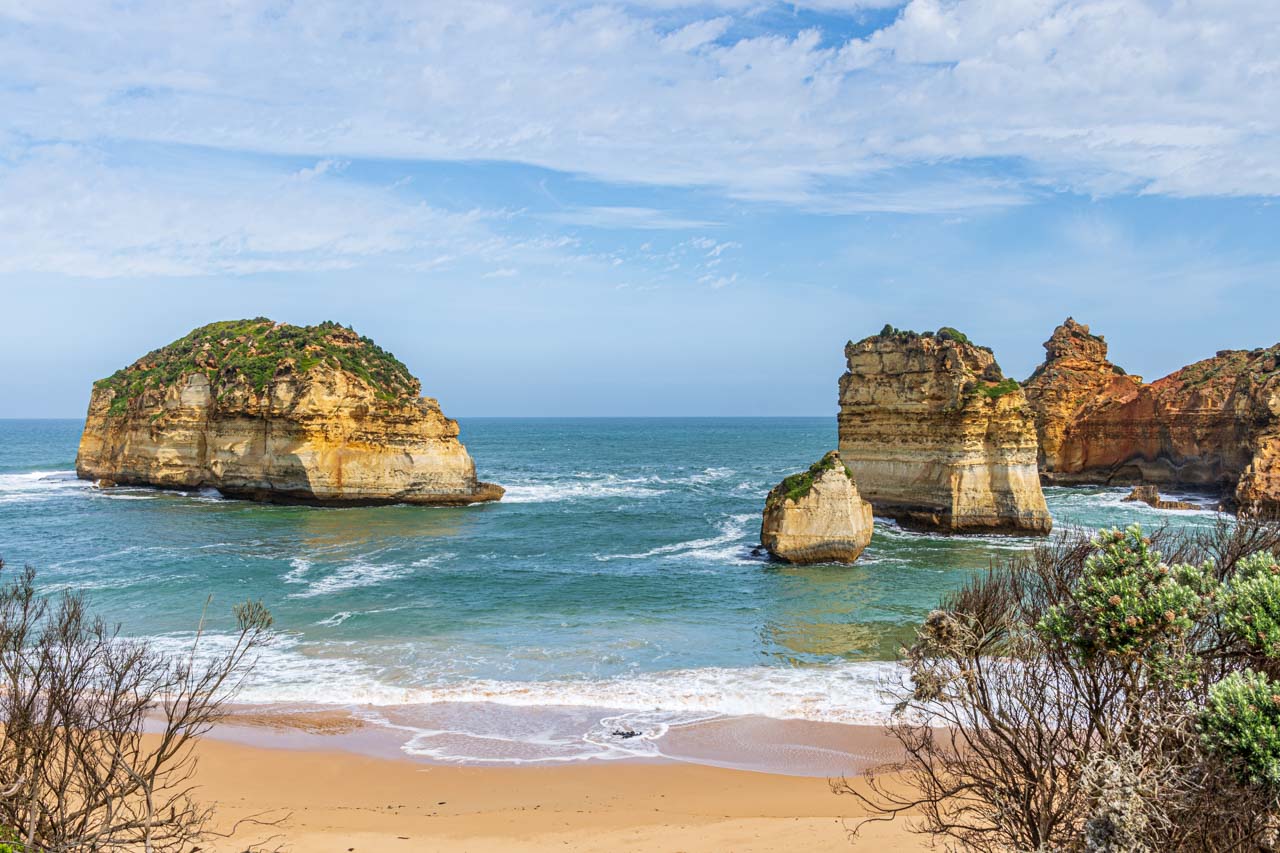
The Twelve Apostles, Port Campbell National Park
The setting sun turns the ocean pink at the Twelve Apostles
The rising sun is reflected on the limestone stacks of the Twelve Apostles
The Twelve Apostles is one of Australia’s iconic landmarks and the most photographed along the Great Ocean Road.
The Twelve Apostles is a collection of limestone stacks off the shore of Port Campbell National Park, formed by erosion over millions of years. The harsh and extreme weather conditions from the Southern Ocean along Victoria’s coast gradually erode the soft limestone to form caves in the cliffs, which become arches that eventually collapse, leaving rock stacks. Just as the winds and rough waves create the stacks, they also destroy them.
Despite the name, there were never twelve rock stacks, only ever nine. The nine became seven (according to Parks Victoria) after one collapsed in 2005 and another in 2009.
The Twelve Apostles was originally known as Sow and Pigs, with Muttonbird Island being the sow and the stacks being the pigs. The name change was solely due to marketing purposes, as the ‘Twelve Apostles’ had a better ring to it.
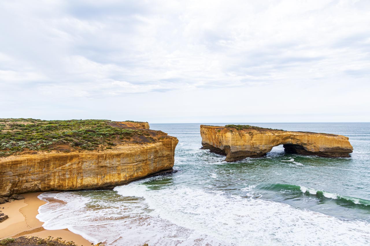
London Bridge, Port Campbell National Park
The arch of London Bridge was once connected to the mainland by a natural span that people could walk across, hence the name. The span collapsed on 15th January 1990, disconnecting the arch from the mainland forever. At the time of the collapse, two tourists were stranded on top of the arch and had to be rescued by helicopter. No one was injured in the event.
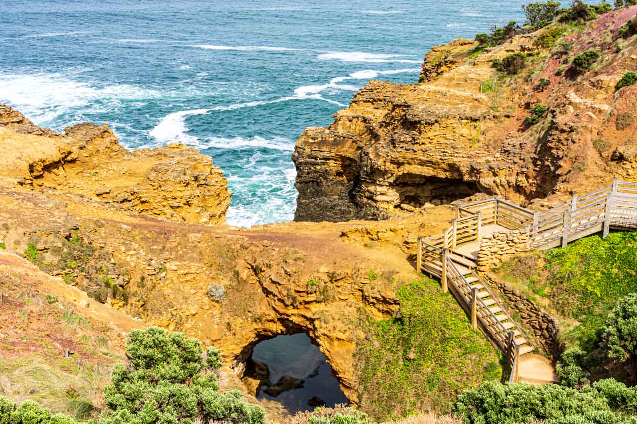
The Grotto, Port Campbell National Park
The Grotto, nine kilometres west of Port Campbell, is a cave, sinkhole, and archway all in one. The Grotto is a natural phenomenon formed over millions of years of crashing waves and high winds eroding the rocks, resulting in a caved sinkhole within the limestone cliffs.
You can reach the bottom via a wooden staircase that winds down the cliff face from the viewing platform at the top.
Sandy Cove, Bay of Islands Coastal Park
Characterised by offshore limestone rock stacks, Sandy Cove is a hidden gem along the Great Ocean Road.
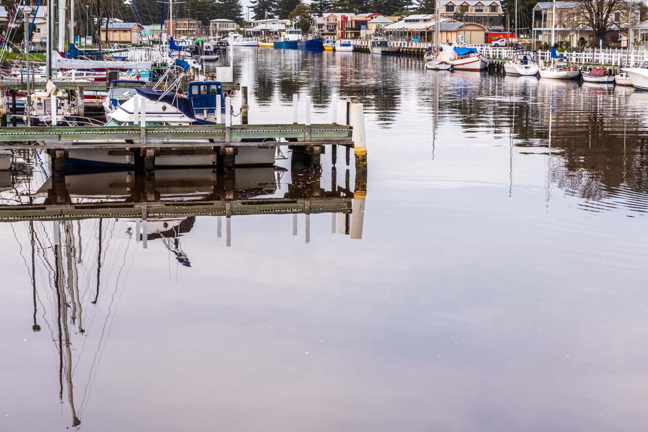
Moyne River boat moorings, Port Fairy
Port Fairy is a historic fishing town located on the Moyne River.
Griffith Island Lighthouse, Port Fairy
Sunset shoot of Griffith Island lighthouse
Griffith Island Lighthouse is situated at the end of a 400-metre walk along the causeway from Martin’s Point in the historic town of Port Fairy. It was built in 1859 and saw the last lighthouse keeper in the 1950s when the light, visible over 19 kilometres out to sea, was automated. The lighthouse is still fully operational, guiding ships into the Moyne River.
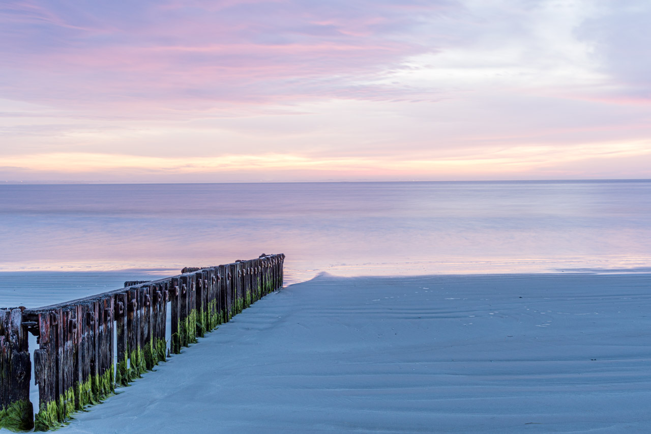
Port Fairy groynes
Sunrise shoot of the timber groynes at East Beach, Port Fairy
Groynes are structures (usually made of wood, concrete, or stone) built out into the sea from a beach to control erosion and drifting. Port Fairy’s groynes were placed at the southern end of the East Beach to stabilise the sand that had been eroding.
Tip: Fingerless gloves would be a good investment for sunrise shoots.
Where we stayed
I recommend the accommodation chosen by Mark Gray Photography on our Great Ocean Road Photo Tour.
On our five days / four nights trip, we stayed one night in Apollo Bay, two nights in Port Campbell, and one night in Port Fairy.
Seafarers Getaway, Apollo Bay, is situated opposite a private beach with all accommodation offering uninterrupted beach and coastal views. I had a well-equipped Beach Studio Unit with a furnished front deck and spectacular views of the breaking waves on the sand. The only downsides were six wall pegs in place of a wardrobe – okay for one night but would be annoying if staying longer – and the rug-less tile floors, which are great in summer but cold on the feet in winter.
Southern Ocean Villas, Port Campbell, is luxury accommodation on the edge of Port Campbell National Park and only a five-minute drive to the Twelve Apostles. Each villa is fully self-contained with two or three bedrooms, an open-plan kitchen and lounge/dining area, laundry, and an outdoor deck with table and chairs. While the bedrooms were dark (not an issue), the living area was light and airy.
Victoria Apartments, Port Fairy, is in the heart of the township of Port Fairy. I stayed in a one-bedroom suite, but other accommodation types are available. The suite’s living area was open planned, but the kitchenette was tiny. However, its winning features were a separate bedroom and a private courtyard. The accommodation was small and a bit cramped but adequate for a short stay for one person.
The 5-day Great Ocean Road Photo Tour with Mark Gray Photography was not a holiday but a dedicated photography workshop and is advertised as such. Our days were long and busy, often starting at sunrise, with little time to relax. But it was a unique way to visit the Great Ocean Road’s fantastic attractions and certainly met my long-term desire to ‘see’ the Great Ocean Road. Furthermore, I learned so much about my camera and landscape photography and came away with photos I am proud of.
You don’t have to be a photographer to appreciate the spectacular scenery and landscapes that the Great Ocean Road offers up at every turn. Take your time to discover and explore this most iconic Australian road trip along Victoria’s rugged southern coastline.
Disclaimer: This post contains no affiliate links. All views and opinions are my own and non-sponsored. All photos are my own and remain the copyright of Just Me Travel.
Visit Rochester Victoria – 3 Excellent Reasons to Plan Your Next Great Escape Are you looking for a day trip or overnight stay in rural Victoria? On the Campaspe…
Visit Rochester Victoria – 3 Excellent Reasons to Plan Your Next Great Escape
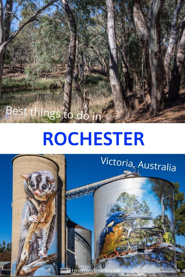
Are you looking for a day trip or overnight stay in rural Victoria? On the Campaspe River, Rochester is an idyllic spot to see silo art, take an informative walk through the Australian bush, and eat good food. My one-day guide will take you there.
On a 12-day road trip around Victoria, my sister and I stopped over in Bendigo and Ballarat, travelled the silo art trail, photographed our reflections on Lake Tyrrell, explored the Lakes District around Kerang, and walked the Koondrook Barham Redgum Statue Walk.
Rochester was our last stop, arriving late afternoon. The following day, we viewed Rochester’s silo artworks and took the river walk before heading home in the early afternoon. These are two of the best things to see and do in Rochester. The third best thing to do in Rochester was eating – well worth mentioning, given our food experience on this road trip.
Where is Rochester
Situated on the Campaspe River in Victoria (Australia), Rochester is 27 kilometres south of the Murray River Port of Echuca. The Murray River, in New South Wales, forms the border with Victoria and is Australia’s longest river.
Taking the fastest route, according to Google maps, Rochester is 187 kilometres north of Melbourne, 27 kilometres south of Echuca, and 240 kilometres south-west of the twin cities, Albury/Wodonga.
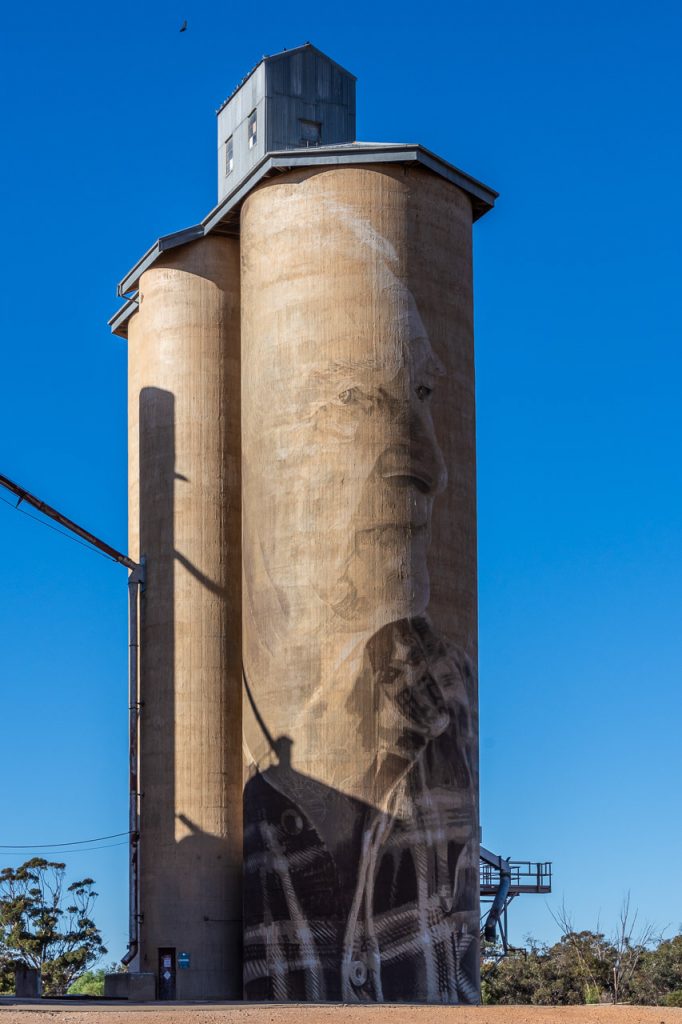
Silo artwork
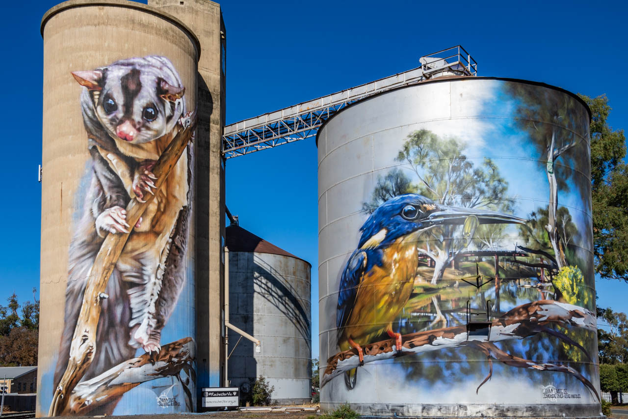
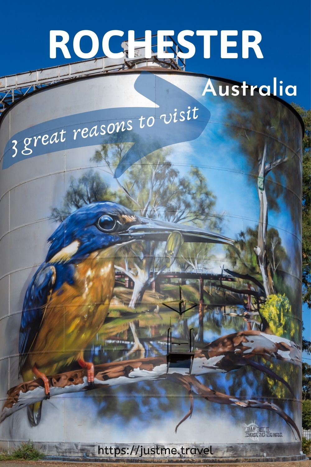
Silo artworks of Squirrel Glider and Azure Kingfisher at Rochester, Victoria.
Rochester’s Silo Art project was the initiative of Rochester Business Network, with support from local businesses and the community. GrainCorp provided the silos as ‘creative’ canvases for artworks on a massive scale. To give you an idea of perspective, the concrete silo is 22 metres high (approximately 72 feet), while the height of the metal silo is 18 metres (about 59 feet).
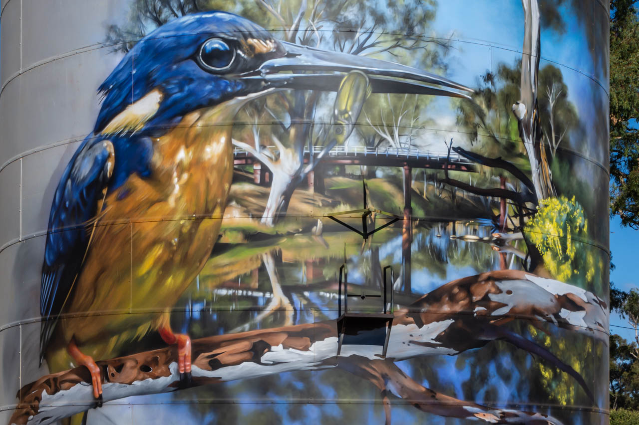
The painted silos are in the heart of town. They feature the endangered Squirrel Glider on the concrete silo and the Azure Kingfisher on the metal silo. Both are native to Australia.
The painted silos, completed in 2018, is an open-air gallery that never closes and is free to visit. It is street art at its best.
The artist who designed and painted these magnificent murals, Jimmy DVate, is the same artist who painted the silos at Goorambat in North East Victoria.
Jimmy is a Melbourne based artist and graphic designer whose talent is recognised nationally and internationally. He is passionate about conservation and is particularly keen to highlight the plight of endangered species. Painting threatened Australian native fauna is a ‘signature’ of Jimmy’s artwork.
Of all the silo artworks we saw on this road trip around Victoria, which took in the Silo Art Trail, the Rochester painted silos were my sister’s favourite. They rate very highly on my list too. I think I must have an affinity with Jimmy DVate’s artworks as his paintings on the silos at Goorambat are also at the top of my favourites list.
The endangered Squirrel Glider painted on Rochester’s grain silo
River Walk
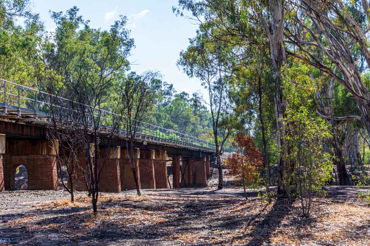
Walking from the painted silos, we made our way to Rochester’s Red Bridge, a timber rail bridge crossing the Campaspe River at the northern end of Ramsay Street. Built in 1876, the Red Bridge consists of three openings of 14 metres spanning the river and 16 openings of seven metres over the flood plain.
Red Bridge – the rail bridge crossing the Campaspe River at Rochester
The Red Bridge features in the background in the silo artwork of the Kingfisher.
Rochester’s Red Bridge features in the background on the silo artwork of the Kingfisher
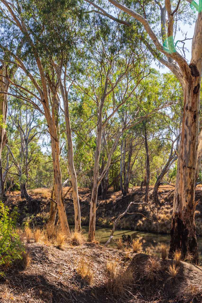
The Red Bridge was our starting point for the 3-kilometre signposted river walk through the urban bushland of the Campaspe River Reserve at Rochester.
The red dotted line indicates the river walk on the map below – taken from the brochure, Experience Rochester, courtesy of Rochester’s Visitor Information Centre.
Map of Rochester, Victoria, showing the river walk route
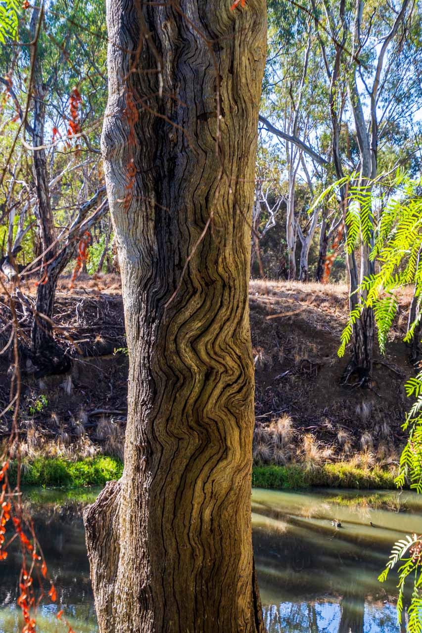
The trail meanders beside the Campaspe River through the iconic Australian bush. The Australian bush always gives me that sense of being home, no matter where I am experiencing it in Australia. And this walk did not disappoint. It was so peaceful. Just us two and birdsong.
The river walk was an easy 3-kilometre walk along the riverbank. Being flat, it was not in the least bit challenging. Benches provided a place to sit for a while and immerse yourself in the stillness and tranquillity.
The trees provide a habitat for local wildlife. My sister enjoyed seeking and identifying the different species of native birds.
Rochester’s river walk through the Campaspe River Reserve is not just a bush walk but a history lesson along the way. Plaques dot the trail at specific points of local historical interest, providing insight into how the local Aboriginal people used the area. For example, pointing out ‘scarred’ trees caused when the Aboriginal people stripped the bark to make canoes, shields, containers, and shelters. And the grooved rocks from grinding their axes.
The Campaspe River is a tributary of the Murray River. It is slow-flowing along the Reserve’s walk – as evidenced in the photos I took of the bush reflected in its waters.
Walk along the banks of the Campaspe River in Rochester’s Campaspe River Reserve
Walking through the Australian bush along the banks of the Campaspe River in Rochester
When to go
We visited Rochester in the first week of May, towards the end of Australia’s autumn. In May, the average daytime temperature for Rochester is 17 degrees Celsius, with an average of 5 rain days for the month. The temperature was just right for a bushwalk along the river.
If you are looking at visiting Rochester at another time of year and wondering what the weather will be, you can find the information you need at FarmOnline Weather.
Where to eat
On our 12-day road trip around Victoria, we struggled to find decent food. Food that gives you that feeling of satisfaction. Food that lets you know you have eaten well. We could count on one hand the number of good meals we had on this road trip. But Rochester scored 2 out of 2 – dinner at the Shamrock Hotel and breakfast at Kits Kafe.
Our decision to try the centrally located, historic Shamrock Hotel for dinner was a good one (corner of Gillies and Moore Streets). I had crumbed lamb chops on a bed of mashed potatoes with seasonal steamed vegetables. My sister had the Thai Beef Stir Fry. We both agreed the food was excellent. These were some of the best pub meals we had ever eaten and were thoroughly enjoyed. Had we been staying another night, we would have gone back for seconds as there was much more on the menu we wanted to try.
Breakfast at Kits Kafe (51 Moore Street) was a yummy affair. We both had the pancakes – mine with maple syrup and bacon and my sister’s with fruit cumquat and bacon. The service was excellent, the food was delicious, and the coffee was worth going back for after our river walk.
We could see the silo artworks across the road from the Kits Kafe.
Where to stay
In Rochester, we stayed at the Rochester Motel, but there are other accommodation options available.
Next time I overnight in Rochester, I would like to stay at The Tavern (49 Moore Street) – bed and breakfast accommodation offering boutique queen rooms with ensuite.
Our main reasons for stopping overnight at Rochester were to break the journey between Kerang and Albury and see the silo artworks I had heard much about. The river walk was an enjoyable bonus, as was our food experience. In all, we came away feeling delighted with our visit to Rochester.
Editor’s Note: This blog post was originally published in July 2019 and has been updated for accuracy and comprehensiveness.
Comment below to share your thoughts on this blog post. Are amazing silo art, a beautiful river walk, and good food enough to tempt you to visit Rochester? What else would you recommend people see and do in Rochester?
The Best Authentic Road Trip to Victoria’s Silo Art Trail and the Artists Behind the Murals Take a road trip with a difference – travel along the Silo Art Trail…
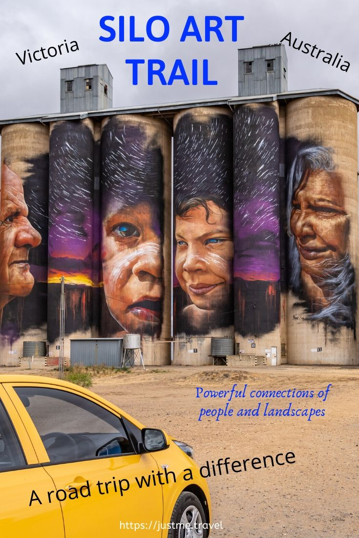
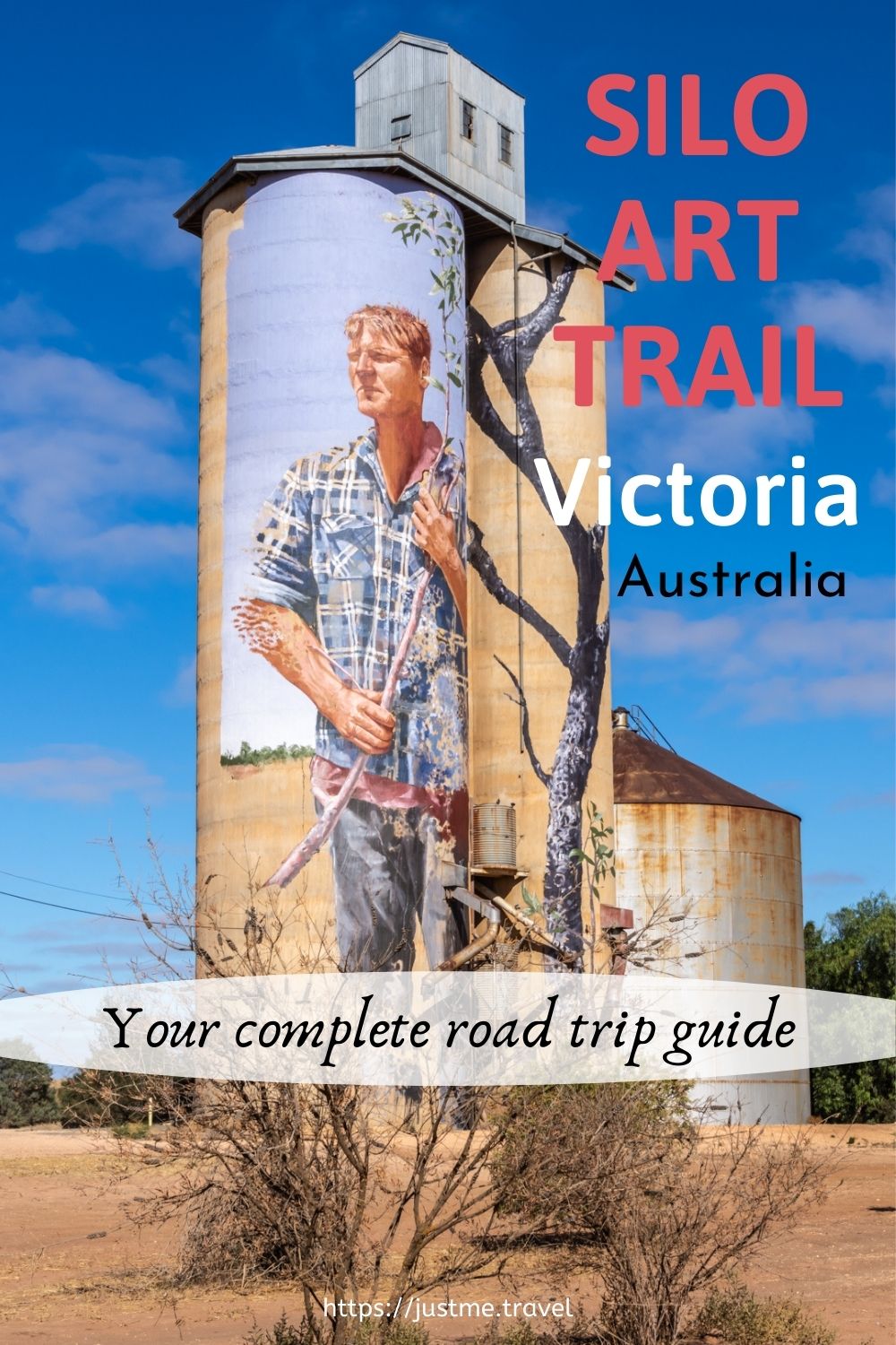
The Best Authentic Road Trip to Victoria’s Silo Art Trail and the Artists Behind the Murals
Take a road trip with a difference – travel along the Silo Art Trail in Victoria, Australia. See how disused grain silos have been transformed into unusual, towering art canvases. Each canvas is unique, with murals reflecting the people, landscape and culture of the community in which they appear.
Empty grain storage silos are scattered around rural Australia. Silo art projects (with the first completed in 2015) have become a national phenomenon, appearing in Victoria, New South Wales, Western Australian, South Australia, and Queensland. The silos provide a canvas for creations that are reinvigorating some of Australia’s smallest and most remote regional towns. They have become a lifesaver for rural communities, bringing tourism to towns that have been seriously struggling due to economic decline.
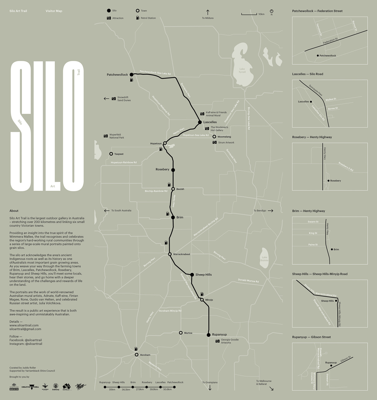
Perhaps the best-known silo art project is the painted silos in Western Victoria; in the Wimmera Mallee region. Here, six painted silos form a 200-kilometre route from Rupanyup in the south (if coming from Ballarat, as we did) to Patchewollock in the north. This is the Silo Art Trail.
My sister and I took a 12-day road trip around regional Victoria – from Albury to Bendigo, to Ballarat, to Hopetoun, to Sea Lake, to Rochester, and back to Albury. The road trip deliberately incorporated the Silo Art Trail in the Wimmera Mallee region as I had read so much about it and had a strong desire to see the murals for myself. My desire was heightened after visiting the painted silos in North East Victoria.
The Silo Art Trail is Australia’s largest outdoor gallery. The trail stretches over 200 kilometres in Victoria’s Wimmera Mallee region, linking the towns of Rupanyup, Sheep Hills, Brim, Rosebery, Lascelles, and Patchewollock.
Providing an insight into the true spirit of the Wimmera Mallee, the trail recognises and celebrates the region’s people through a series of large-scale mural portraits painted onto grain storage silos, many of which date back to the 1930s.
The national and international artists whose murals appear on the silos spent time visiting the region and meeting the locals before transforming each grain silo into an epic work of art. Each mural tells a unique story about the host town.
The level of detail the artists have achieved in their murals is impressive. Something I find astonishing given the scale of the artworks. How do you create such fine detail with an aerosol can?
The Silo Art Trail was conceived in 2016 after the success of the first artwork in Brim. What started as a small community project by the Brim Active Community Group to save their town from extinction resulted in widespread international media attention and an influx of visitors to the region. The idea for the Trail was born.
Whether in a car, motorhome or towing a caravan, parking is not a problem at any of the silos.
The Silo Art Trail website provides detailed information on other attractions to visit while in the area, including murals in some towns and painted silos at Nullawil, Goroke, Kaniva and Sea Lake. Taking in these additional painted silos extends the route to 330 kilometres from end to end.
Why you should visit the Silo Art Trail
This is street art at its best.
The murals are painted on unusual canvases.
The silo artworks are in public spaces; in outdoor galleries open 24 hours a day / 7 days a week. And they are free to visit.
It is artwork on a massive scale. How many paintings do you know that require an extended cherry picker to complete?
The murals painted on the silos depict local community members, giving an insight into the area.
Grain storage silos have been ‘painted’ on Australia’s landscape since the 1920s.
Victoria’s Silo Art Trail is Australia’s ultimate road trip.
Getting there
While you can travel the route in any direction, I will take you from Rupanyup in the south to Patchewollock in the north – the approach we took on our road trip.
-> From Melbourne to Bendigo is 151 kilometres (approximately a 2-hour drive). From Bendigo to Rupanyup is 169 kilometres (approximately a 2-hour drive)
-> From Melbourne to Ballarat is 112 kilometres (a 1-hour and 39-minute drive). From Ballarat to Rupanyup is 177 kilometres (a 2-hour drive).
As you can see, it is really neither here nor there as to whether you arrive in Rupanyup from Melbourne via Bendigo or Ballarat. My preference would be to travel via Bendigo, a historic gold mining town with some of the best food we had on the whole road trip. Historic Bendigo Pottery is worth a visit. Don’t miss Bendigo Pottery’s museum.
Other helpful distances:
> From Bendigo to Patchewollock is 284 kilometres. If stopping 30 minutes at each silo artwork, the entire trip would take approximately 6 hours, 11 minutes.
> From Ballarat to Patchewollock is 332 kilometres. If stopping 30 minutes at each silo artwork, the trip would take approximately 6 hours, 42 minutes.
> From Patchewollock to Sea Lake (possible accommodation option) is 73 kilometres – a 50-minute drive.
> From Patchewollock to Mildura (possible accommodation option) is 141 kilometres – a drive time of approximately 1 hour, 38 minutes.
> From Patchewollock to Swan Hill (possible accommodation option) is 145 kilometres – a drive time of approximately 1 hour, 36 minutes.
The distances from silo to silo:
Rupanyup to Sheep Hills is 35 kilometres;
Sheep Hills to Brim is 36 kilometres;
Brim to Roseberry is 28 kilometres;
Roseberry to Lascelles is 40 kilometres;
and Lascelles to Patchewollock is 51 kilometres.
Rupanyup Silo Art by Julia Volchkova
Rupanyup silo art of young people from local sporting teams on Victoria’s Silo Art Trail
Completed early 2017, the faces featured on the silos are those of Rupanyup residents and local sporting team members Ebony Baker and Jordan Weidemann. Dressed in their sports uniforms (netball and Australian Rules football, respectively), the mural captures the spirit of community while honouring the integral role that sport and community play in rural Australia.
Rupanyup’s silo art is the work of Russian mural artist Julia Volchkova. The monochromatic work is typical of Volchkova’s realist portraiture style. An avid traveller, her frequent travels have resulted in numerous large-scale murals of local people in Indonesia, Malaysia and elsewhere around the world.
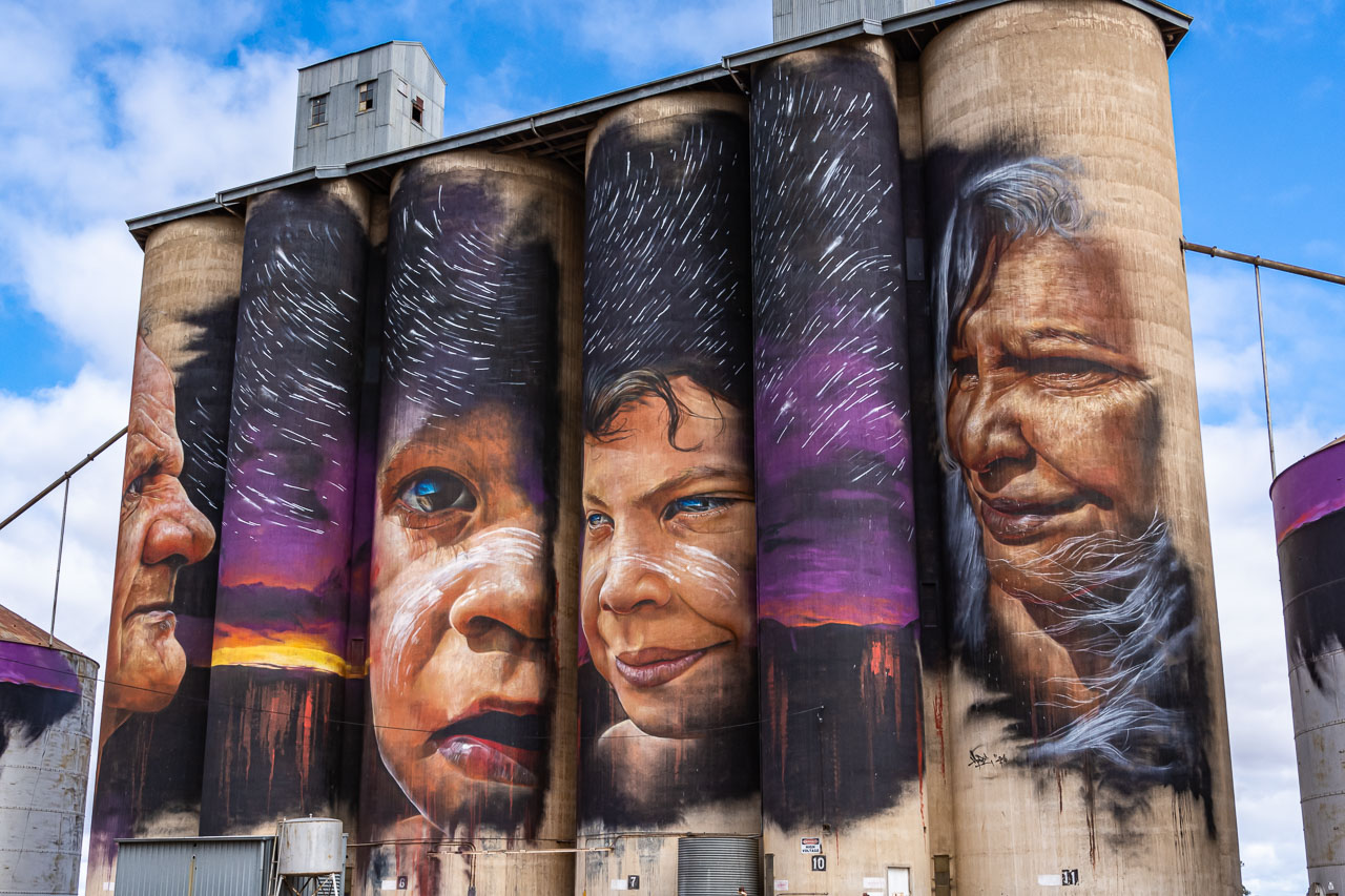
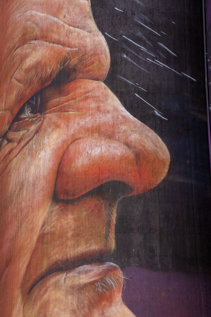
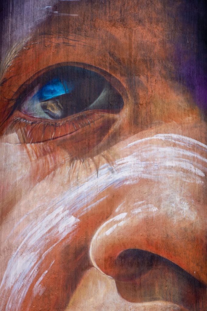
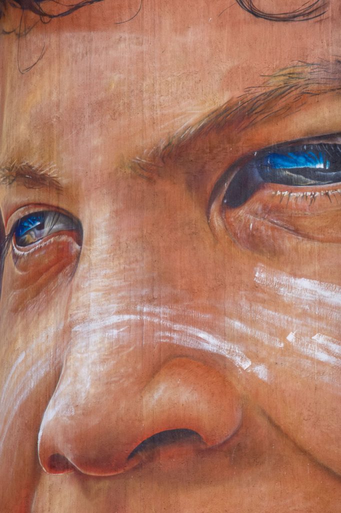
Sheep Hills Silo Art by Adnate
Sheep Hills silo art of Aboriginal Australians on Victoria’s Silo Art Trail
Melbourne-based artist, Adnate, uses his artwork to tell stories of Indigenous people and their native lands, particularly Aboriginal Australians. He painted the mural on the silos at Sheep Hills in 2016 after spending four weeks with the community. He found his inspiration for the mural after developing a friendship with the Barengi Gadin Land Council in North East Victoria.
Through his portraits of Wergaia Elder, Uncle Ron Marks, and Wotjobaluk Elder, Aunty Regina Hood, alongside two young children, Savannah Marks and Curtly McDonald, Adnate celebrates the richness of the area’s Indigenous culture.
Sheep Hills silo art of the face of Wergala Elder, Uncle Ron Marks on Victoria’s Silo Art Trail
Sheep Hills silo art of the face of Aboriginal Australian child, Savannah Marks on Victoria’s Silo Art Trail
Sheep Hills silo art of Aboriginal Australian child, Curtly McDonald on Victoria’s Silo Art Trail
Sheep Hills silo art of Wotjobaluk Elder, Aunty Regina Hood on Victoria’s Silo Art Trail
The night sky in the mural represents elements of local dreaming, and the overall image signifies the critical exchange of wisdom, knowledge and customs from Elders to the next generation.
Featuring a bold use of block colours via acrylic and spray paint, Adnate’s portraits are known for introducing an energetic presence to their surroundings. Described as “life-like” and “emotive”, his large-scale murals can be found in various settings throughout Australia and worldwide.
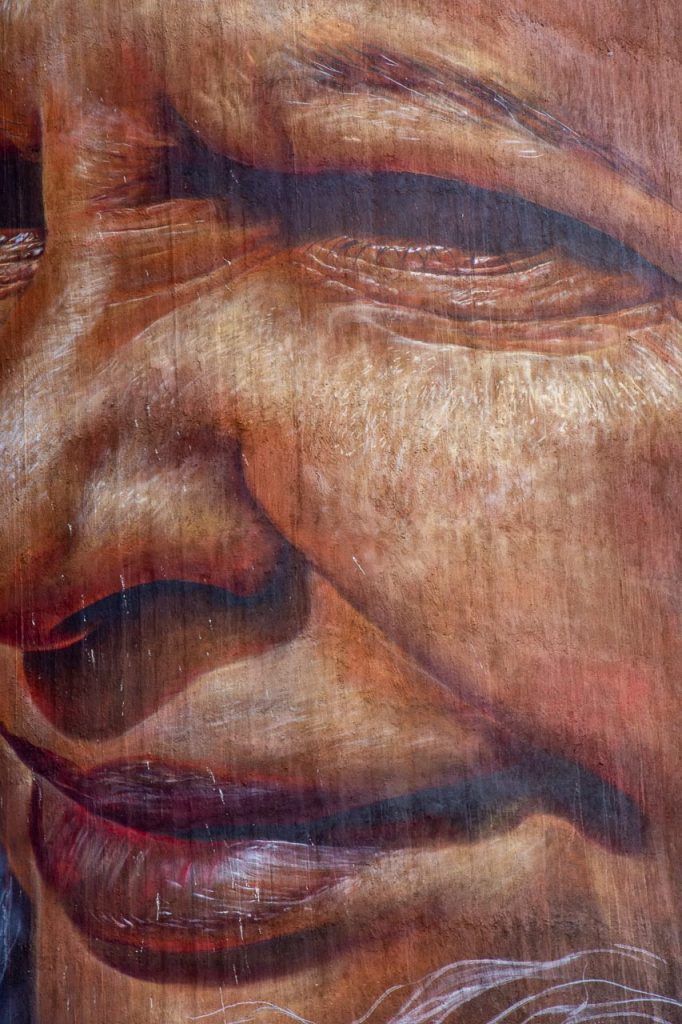
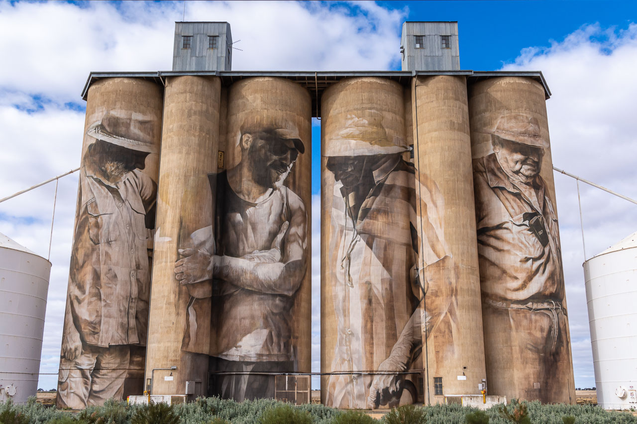
Brim Silo Art by Guido van Helten
Brim silo art of multi-generational male and female farmers on Victoria’s Silo Art Trail
Although the third silo artwork along the Silo Art Trail (travelling from Melbourne), the mural painted on the disused GrainCorp silos at Brim, was the first to be painted in Victoria and was the inspiration for the Silo Art Trail.
Painted by world-renown Australian street artist Guido van Helten, his mural of four anonymous, multi-generational farmers (three men and one woman) was completed in January 2016. Guido’s subjects bear expressions that exemplify the strength and resilience of the local farming community as they face immense economic pressure and the tangible consequences of climate change. His work captures the spirit of the local area and connects the characters to their chosen place, infusing the landscape with a comforting, familiar presence.
Face of the middle-aged male farmer on the Brim silo on Victoria’s Silo Art Trail
Face of the youngest male farmer painted on the Brim silo on Victoria’s Silo Art Trail
Face of the only female farmer on the Brim silo on the Silo Art Trail
Face of the oldest male farmer on the Brim silo on Victoria’s Silo Art Trail
Celebrating everyday characters in forgotten places, Guido’s monochromatic, photorealistic style offers an intimate glimpse into the lives of others. His large-scale portraiture murals are found throughout Europe, Scandinavia, the United States, and Australia. They tell stories of culture, history, and identity to capture the soul of people and place.
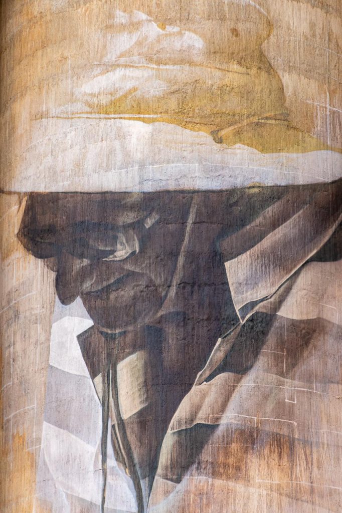
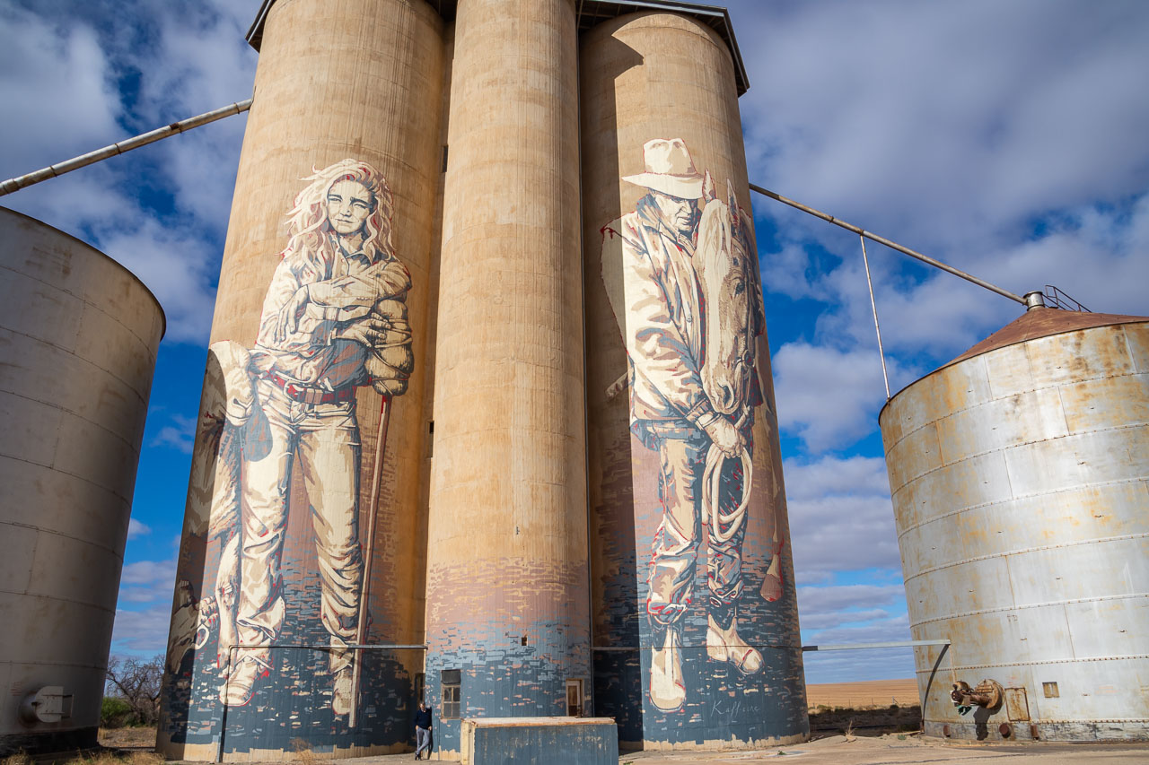
Rosebery Silo Art by Kaff-eine
Rosebery silo art of female farmer and horseman with his horse on Victoria’s Silo Art Trail
The silo on the left captures the grit, tenacity and character of the region’s young female farmers, who regularly face drought, fires and other hardships living and working in the Wimmera Mallee. In her work shirt, jeans and turned-down cowboy boots, the young female sheep farmer symbolises the future.
The silo on the right portrays the strong connection between man and horse. The contemporary horseman appears in an Akubra hat, Bogs boots and oilskin vest – typical attire for Wimmera Mallee farmers. Both man and horse are relaxed and facing downward, indicating their mutual trust, love and genuine connection.
Completed in late 2017 by the successful, internationally renowned street artist, Kaff-eine, her Rosebery mural depicts themes that she says embody the region’s past, present and future.
Combining creativity with a strong social conscience, Kaff-eine makes art and film projects in marginalised communities around the world, with her work inviting audiences to engage with social and political issues. Kaff-eine describes her practice from photorealistic to darkly sensual stylised characters as “loaded with symbolism and narrative”.
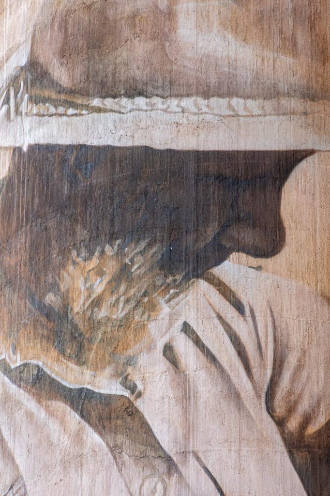
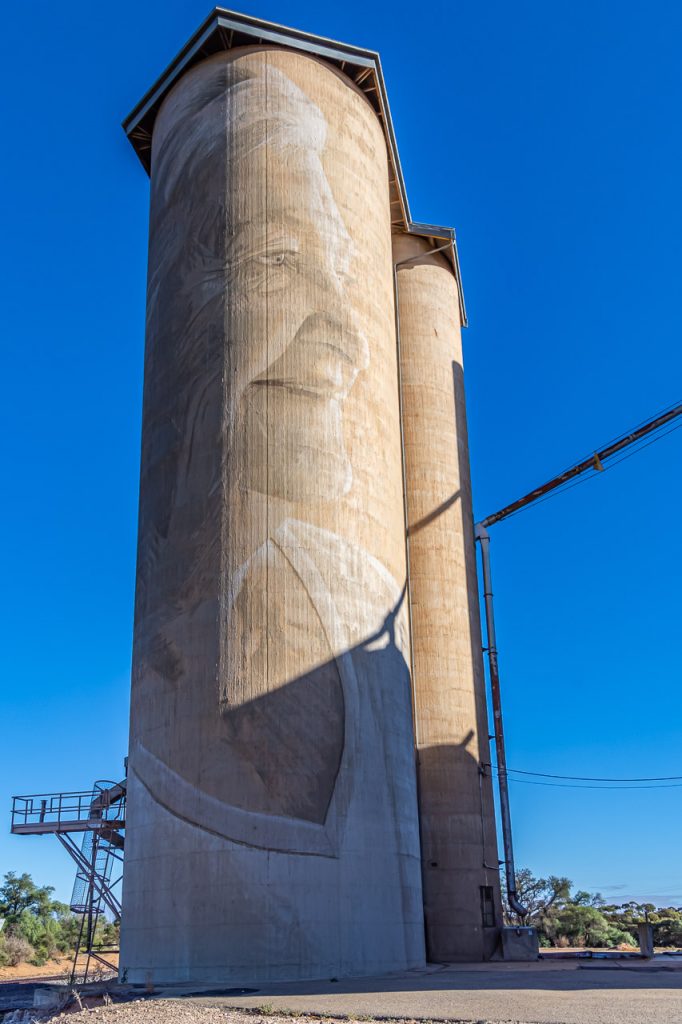
Lascelles Silo Art by Rone
Lascelles silo art of local farmer, Geoff Horman on Victoria’s Silo Art Trail
Lascelles silo art of local farmer, Merrilyn Horman on Victoria’s Silo Art Trail
The artwork here of the local farming couple, Geoff and Merrilyn Horman can never be photographed together because they are painted on opposite sides of two grain silos.
The Horman’s are part of a family who has lived and farmed in the area for four generations. Painted by Rone in mid-2017, he wanted the mural to portray his subjects as wise and knowing, nurturing the town’s future with their vast farming experience and longstanding connection to the area.
Rone worked for two weeks to transform the two 1939-built GrainCorp silos. He went to great lengths to paint in the silo’s existing raw concrete tones to produce a work that would integrate sensitivity into its environment. Utilising this muted monochrome palette, he added water to his paint as a blending tool to create a ghostly, transparent effect – a signature of his distinctive painting style.
An influential figure in Australia’s early street art scene, Rone is perhaps best known for his large-scale “Jane Doe” portraits, featuring beautiful young women painted onto old, decaying backgrounds. This interplay between beauty and decay is a key theme throughout his work, emphasising the fleeting nature of beauty and encouraging audiences to appreciate it while it lasts.
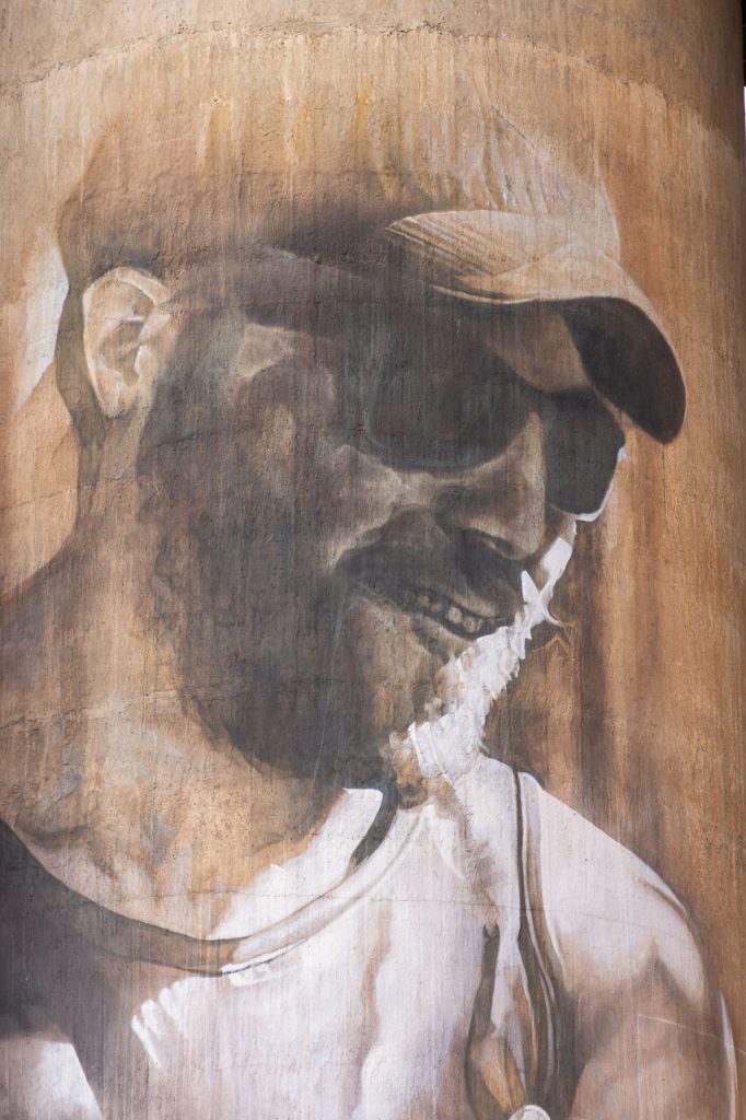
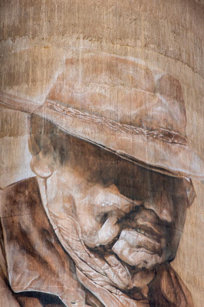
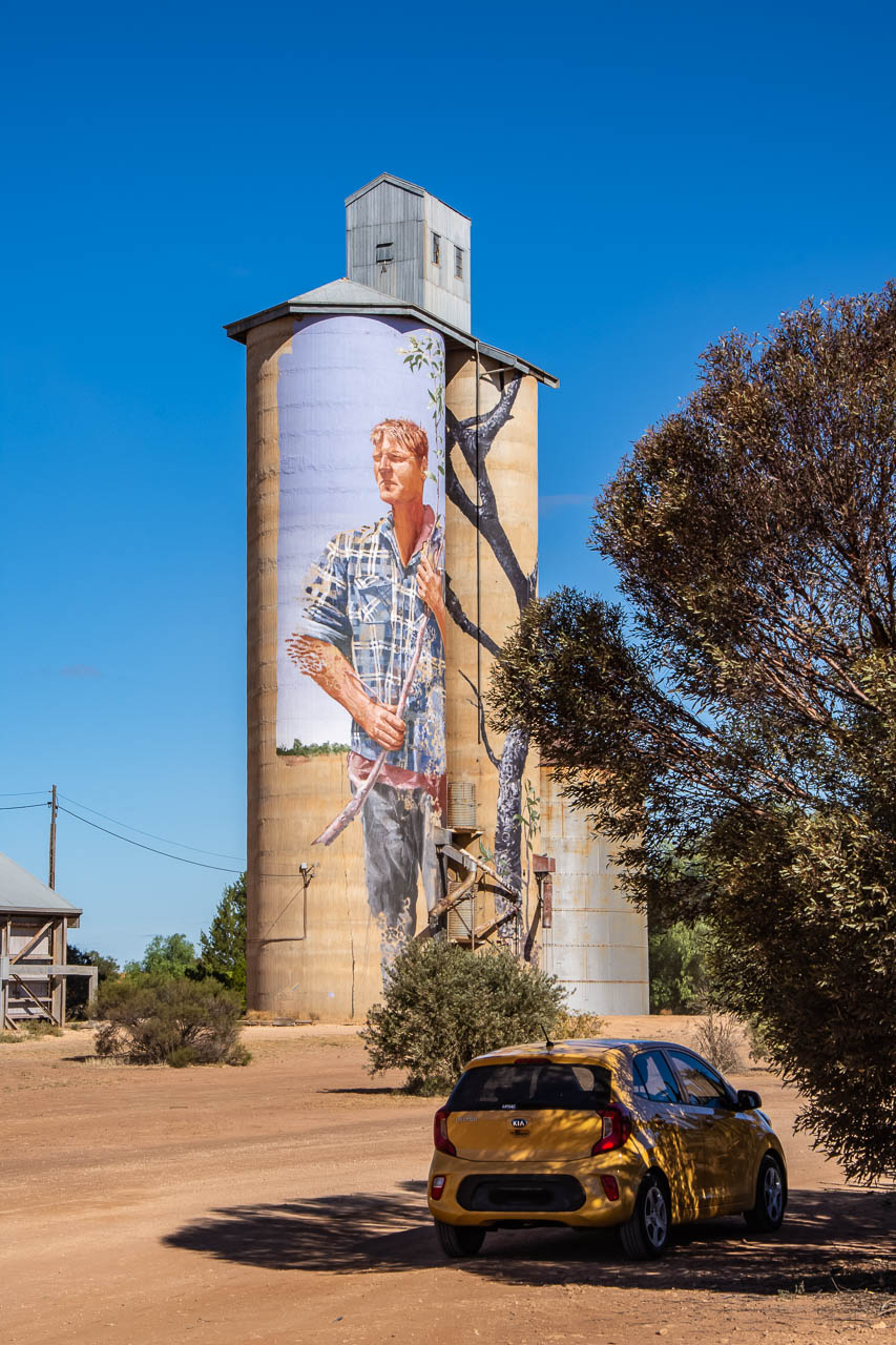
Patchewollock Silo Art by Fintan Magee
Patchewollock silo art of local farmer, Nick “Noodle” Holland on Victoria’s Silo Art Trail
To prepare his Patchewollock mural, Brisbane artist Fintan Magee booked a room at the local pub to immerse himself in the local community and to get to know its people. When he met local sheep and grain farmer Nick “Noodle” Hulland, Magee knew he had found his subject.
The face of local farmer, Nick Holland on the Patchewollock silo on Victoria’s Silo Art Trail
Why Nick Hulland? According to Magee, the rugged, lanky local exemplified the no-nonsense, hardworking spirit of the region. Perhaps more importantly, though, Hulland had just the right height and leanness to neatly fit onto the narrow, 35-metre-high canvas of the twin 1939-built GrainCorp silos.
Completed in late 2016, Magee’s depiction of the famously reserved Nick Hulland portrays the classic Aussie farmer – faded blue “flanny” (flannelette shirt) and all. Hulland’s solemn expression, sun-bleached hair, and squinting gaze speak to the harshness of the environment and the challenges of life in the Wimmera Mallee.
Combining surreal and figurative imagery with a trained artist’s discipline and technical skill, Magee’s work explores global themes and climate change, displacement and migration, as well as environmental issues such as his family’s experience in the devasting 2011 Brisbane floods. Understanding that not everyone has access to art galleries, Magee aims to make art more accessible to isolated communities and the general public.
When to go
Autumn, in my opinion, March to May, is the best time in Australia. The sting of intense heat wanes, the bush comes alive, the landscape changes colour, the desert sprouts, and the people wake from their summer stupor.
Where to eat
Sub-standard food (with a few exceptions), poor food choices due to limited options, or non-existent food outlets, was typical throughout the whole road trip. At one point, my sister noted in her journal that the food situation was making her unhappy as she was not eating well (and not from choice).
I make two suggestions here:
Eat up big in Bendigo or Ballarat because it’s the last decent meal you will have until after you leave the Silo Art Trail; and
Buy snacks in Bendigo or Ballarat before heading up the Silo Art Trail. If you find you haven’t bought enough or are sick of what you did purchase, you can stock up at the supermarket in Warracknabeal. We made the mistake of eating lunch at the local Chinese restaurant in Warracknabeal because that was what we felt like. Big mistake! However, the chocolate biscuits I bought at the local supermarket were yum and eaten before my sister could blink. Did she want some?
We had several good meals in Bendigo. Our first breakfast was at The Boardwalk on Lake Weeroona (28 Nolan street). The service was faultless, and the food here was so good we ate breakfast at The Boardwalk each morning of our stay in Bendigo. I couldn’t resist the Gourmet Fruit Loaf with Bacon.
Have lunch at The Rifle Bridge Hotel, 137 View Street, Bendigo. Talk about a yummy salad – Chicken and Macadamia Nut Salad with Beetroot, Pear and Figs.
For dinner, Masons of Bendigo, at 25 Queen Street, is a must. Plating is modern Australian, with all dishes (starters, mains and desserts) designed to be shared. We received excellent service from friendly, informative staff. Reservations are essential.
On our first night in Ballarat, we ate at The Forge Pizzeria (14 Armstrong Street) because it was recommended in the Ballarat tourist information booklet. The restaurant was packed, which is always a good sign. My sister enjoyed her pizza, but it was a poor food choice for me, as I am not keen on pizza.
The next day we had lunch at L’Espresso café (417 Sturt Street, Ballarat). A trendy café (people waiting to be seated) with efficient service and, we both commented, excellent food. That night, we ate at The Gallery Restaurant in the Craig’s Royal Hotel (10 Lydiard Street), where we stayed in Ballarat. We had mixed feelings regarding our meals here. I thoroughly enjoyed my main course and dessert. But my sister was not impressed with her meal.
In Rosebery, after viewing the silo art, we passed an old church 228 metres down the road with a sign out the front advertising scones and cream. This couldn’t be real! We were in the middle of nowhere! Turning around, we discovered the old church was now a café, Mallee Sunsets Gallery Café, and it did indeed have scones with jam and cream on its menu. We couldn’t resist. Together with the best ice coffee I probably have ever had (I watched her put six scoops of ice cream in my ice coffee), I was in heaven.
The story of this once Presbyterian Church brought home how much these small, remote farming communities are struggling. It stopped being a church in 1990 because there were only five people left in the congregation. The church’s closure divided the community as those five people then had to attend services in Warracknabeal or Hopetoun. Three went one way, and two went the other.
The final painted silo on our Silo Art Trail road trip was at Patchewollock. Looking to eat lunch after viewing the mural of Nick “Noodle” Hulland, we had two options: the café that only sold sausage rolls they could heat in a microwave, or the Pub. We settle for toasted sandwiches at the “Patche Pub”.
From Patchewollock, we headed to Sea Lake for two nights. At the time, the only meals available for dinner were dispensed from a vending machine at the motel and were disgusting. There were two cafes open for breakfast, but one closed at 5.30 pm (too early for dinner), and the other advertised they close at 8.30 pm. But not this night! They had two tourist coaches in town and had shut the café to all other people. The hotel in Sea Lake has been renovated and is now open for accommodation and meals. Bonus!
So, being very, very hungry by this stage of our latter travels, on our second day in Sea Lake, we drove 45 minutes to Spoons Riverside Café and Restaurant in Swan Hill for lunch. Spoons Riverside is in a beautiful location, overlooking the Murray River. I ate far too much, but the food was so yummy.
Where to stay
Being influenced by tourist information advising that Hopetoun is an excellent base for exploring the gigantic artworks that comprise the Silo Art Trail, we broke our journey for the night in Hopetoun. Both my sister and I strongly recommend you don’t do this. The only accommodation in town was very basic (that I can live with), but my room was filthy. On top of this, our food choices were minimal and tasteless.
The Quality Hotel Lakeside in Bendigo (our ‘home’ for three nights), at 286 Napier Street, is located opposite Lake Weeroona and a stone’s throw from ‘The Boardwalk’, where we had breakfast each morning. A modern hotel, our balconied rooms were very large, with a king-size bed, comfortable lounge, writing desk and tea/coffee making facilities. The hotel also had a guest laundry.
In Ballarat, we stayed at Craig’s Royal Hotel – 10 Lydiard Street, South Ballarat. Located in the historical part of Ballarat across the road from Her Majesty Theatre, this luxury boutique hotel was comfort-plus with an old-world charm. Craig’s Royal Hotel has been a Ballarat icon since 1853.
The drive, via the Silo Art Trail, from Ballarat to Sea Lake, at 405 kilometres, or from Bendigo to Sea Lake, at 357 kilometres, can be done in one day. This is not excessive and easily accomplished with plenty of time to view each of the silo artworks. Don’t make the mistake we made stopping for the night along the Silo Art Trail.
In Sea Lake, we stayed at the Sea Lake Motel on the Calder Highway (93 Railway Avenue, Sea Lake). Our room (the only time we shared a room on this road trip) was small and basic but clean. The now renovated Hotel (pub) on the main street in town may be a better accommodation option.
Patchewollock silo art of Nick Holland and car. The end of Victoria’s Silo Art Trail
What did surprise me was the lack of infrastructure to support tourism along the Silo Art Trail. I’m not referring to the roads. They were in good condition that my little car had no trouble traversing. If the Silo Art Trail has any hope of encouraging the financial sustainability of the towns in questions through tourism and saving them from extinction, then appropriate places to eat and sleep are crucial. We would have seen a maximum of 3 other couples visiting these painted silos. I can understand people are hesitant to open cafes and accommodation when the tourists aren’t there to generate a viable business enterprise. It’s a bit like which comes first, the chicken or the egg. What are your thoughts on this?
I want to leave you with a comment from my sister as she summed up her experience of the Silo Art Trail.
“At first, I was not overwhelmed by the silo art. But on reflection, the use of these giant canvases to reflect community has been interesting and something to remember. Some of them, and their place in the landscape, have affected me. It would be good to go back and look at them quietly and reflect on the landscape.”
For my sister, the people in the murals were of the landscape. A need to further examine the connection between landscape and the art themselves fuelled her desire to return to the Silo Art Trail.
Editor’s Note: This post was originally published in January 2020 and has been updated for accuracy and comprehensiveness.
Disclaimer: This post contains no affiliate links. All views and opinions are my own and non-sponsored. Unless expressly stated, all photos are my own and remain the copyright of Joanna Rath.
Comment below to share your thoughts on this blog post. Tell me which of the painted silos in this post is your favourite.